
September 7, 2026
Unprecedented Trajectory: Typhoon No. 15 Makes Historic Ibaraki Landfall and Crosses Japan Westward



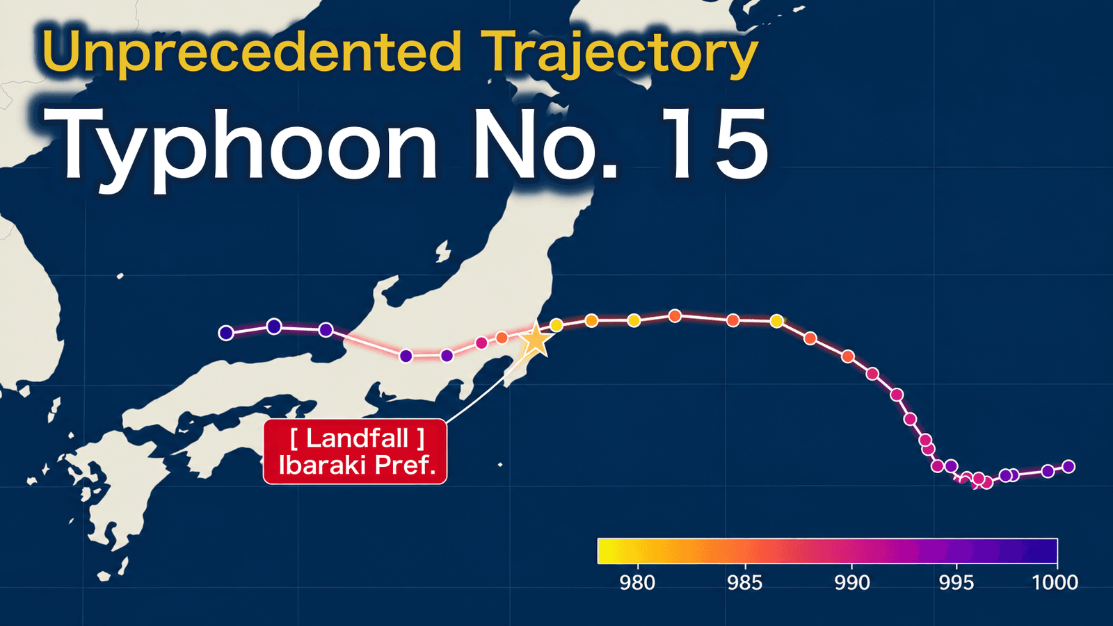
Forming on August 5, 2026, Typhoon No. 15 (Chan-hom) followed a highly unusual trajectory: after initially tracking north, the system abruptly shifted westward, moving in the exact opposite direction of standard typhoon patterns.
The typhoon featured an expansive wind field, affecting a vast region from Kanto to Tohoku as early as half a day before landfall. Even Sendai, located far from the typhoon’s center, recorded wind speeds exceeding 20 m/s, causing significant impacts across the region. Fallen trees and power line damage caused by the strong winds led to power outages affecting more than 3,000 households, mainly in Ibaraki and Tochigi prefectures, through the morning of August 12. Rail services were suspended, expressways were closed, and flights and ferry services were canceled, causing extensive disruptions to lifelines and transportation infrastructure.
Meteorological Overview
Typhoon No. 15 was the second typhoon to make landfall in Japan in 2026, following Typhoon No. 6, which struck Wakayama Prefecture in June.
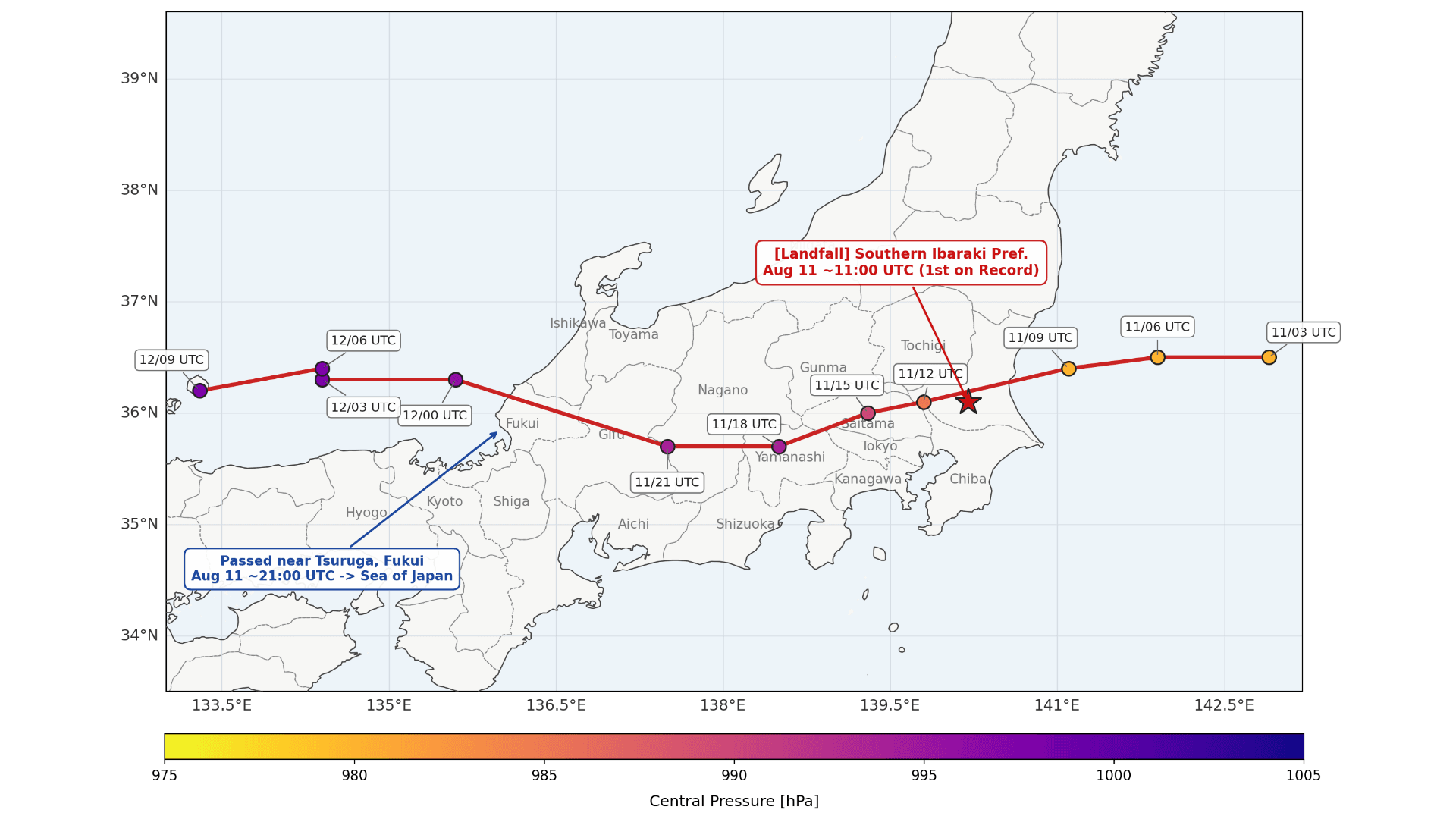
The system formed near Wake Island at 15:00 on August 5 and officially made landfall in southern Ibaraki Prefecture at approximately 20:00 on August 11. Notably, this marked the first recorded typhoon landfall in Ibaraki since the Japan Meteorological Agency (JMA) began maintaining reliable records in 1951.
Following landfall, the system tracked steadily westward across Chiba, Saitama, Yamanashi, Gunma, and Nagano prefectures. It then passed near Tsuruga City in Fukui Prefecture before exiting into the Sea of Japan. Because standard tropical cyclones typically curve northeastward as they interact with mid-latitude westerlies near Japan, Typhoon No. 15 drew intense scrutiny for its anomalous east-to-west trajectory. In domestic media, it was widely dubbed a “reverse-tracking typhoon” due to this rare retrograde path.
Why Did the Typhoon Move Westward? Was It Related to a Super El Niño?
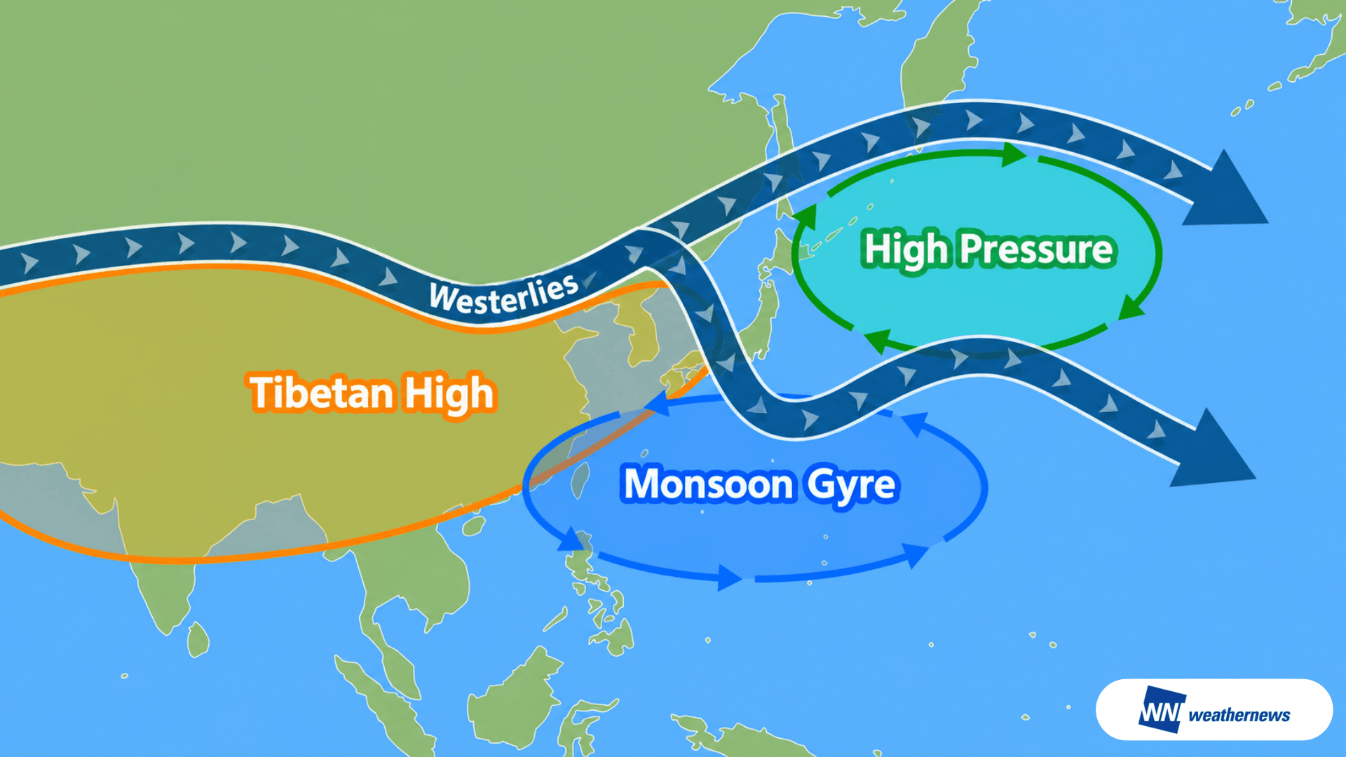
Typhoon No. 15’s anomalous westward track was driven by a complex interaction between the Pacific High and a large-scale low-pressure system, known as a monsoon gyre, developing south of Japan.
Initially, airflow associated with the monsoon trough steered the system northwestward. However, its trajectory abruptly shifted west due to two key atmospheric drivers: easterly winds flowing along the periphery of a high-pressure system near the Kuril Islands, and an upper-level cold-core vortex dropping southward, which effectively pulled the storm westward. This combination ultimately forced the system directly across the Japanese archipelago.
The strengthening of the Kuril Islands high-pressure system and the southward dip of the cold-core vortex were likely triggered by a pronounced meandering of the mid-latitude westerlies over Japan.
While rare, this east-to-west landfall pattern has historical precedents, most notably Typhoon No. 10 in 2016, Typhoon No. 8 in 2021, and Typhoon No. 5 in 2024. Because El Niño conditions were absent during those years, meteorologists conclude there is little direct correlation between retrograde typhoon tracks and El Niño patterns.
Instead, the unifying feature across all these anomalous events was the expansion of the monsoon trough and the presence of a monsoon gyre south of Japan. This large-scale vortex remains a critical factor capable of radically altering standard tropical cyclone trajectories.
Evaluating the Accuracy of the Typhoon Track Forecast
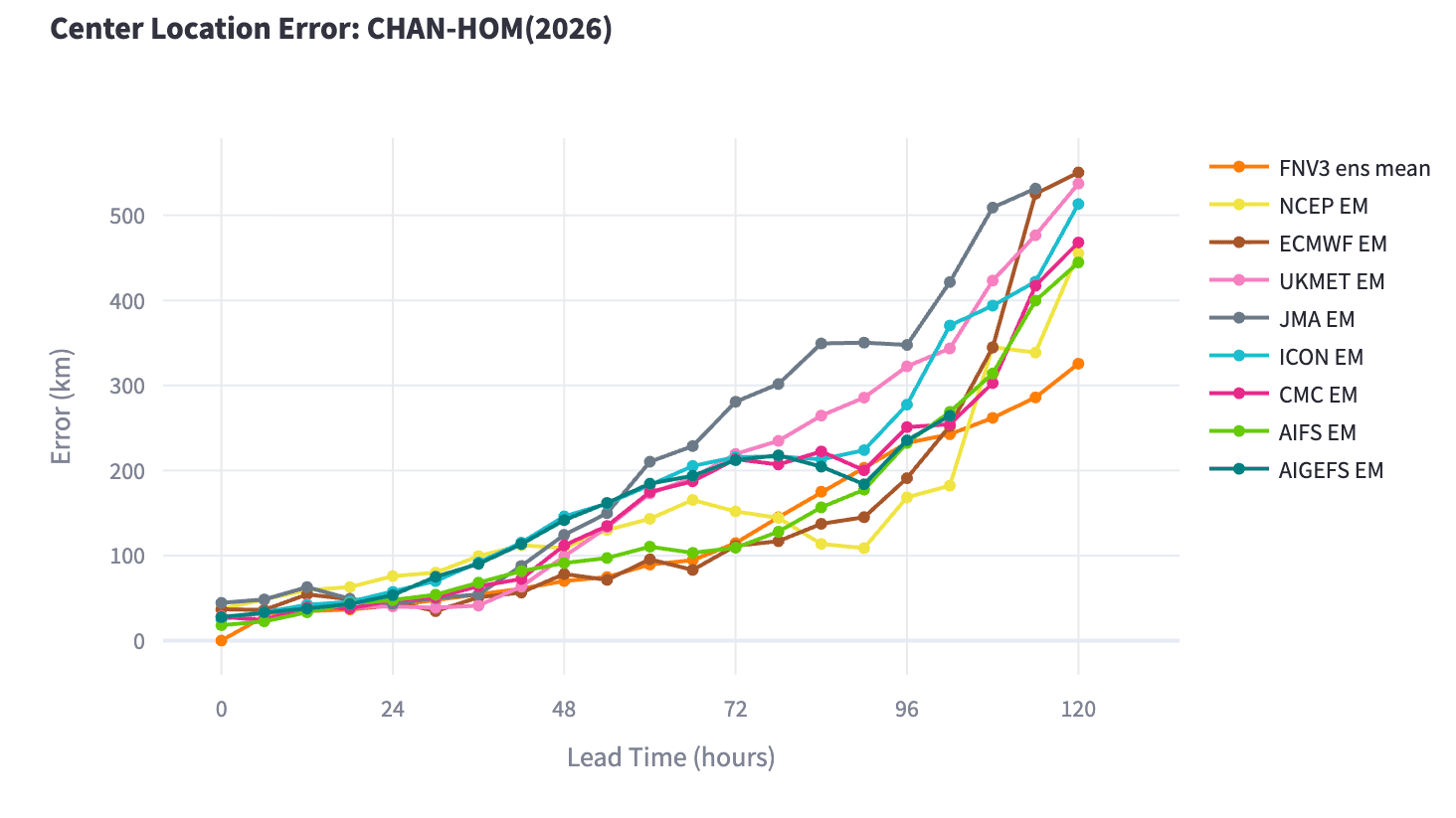
Figure 1 illustrates the relationship between forecast lead time and track error (the distance between the forecast and the observed center of the storm). Google DeepMind’s AI model (FNV ens mean) successfully kept its track error below 350 km through a 120-hour lead time, initially indicating that it captured a trajectory closer to the actual path at an earlier stage than competing models.
FNV ens mean: Google DeepMind (CC BY 4.0) NCEP EM: U.S. National Centers for Environmental Prediction ECMWF EM: European Centre for Medium-Range Weather Forecasts UKMET EM: UK Met Office JMA EM: Japan Meteorological Agency ICON EM: Deutscher Wetterdienst (German Weather Service) CMC EM: Environment and Climate Change Canada AIFS EM: European Centre for Medium-Range Weather Forecasts AIGEFS EM: U.S. National Centers for Environmental Prediction (AI Global Ensemble Forecast System)
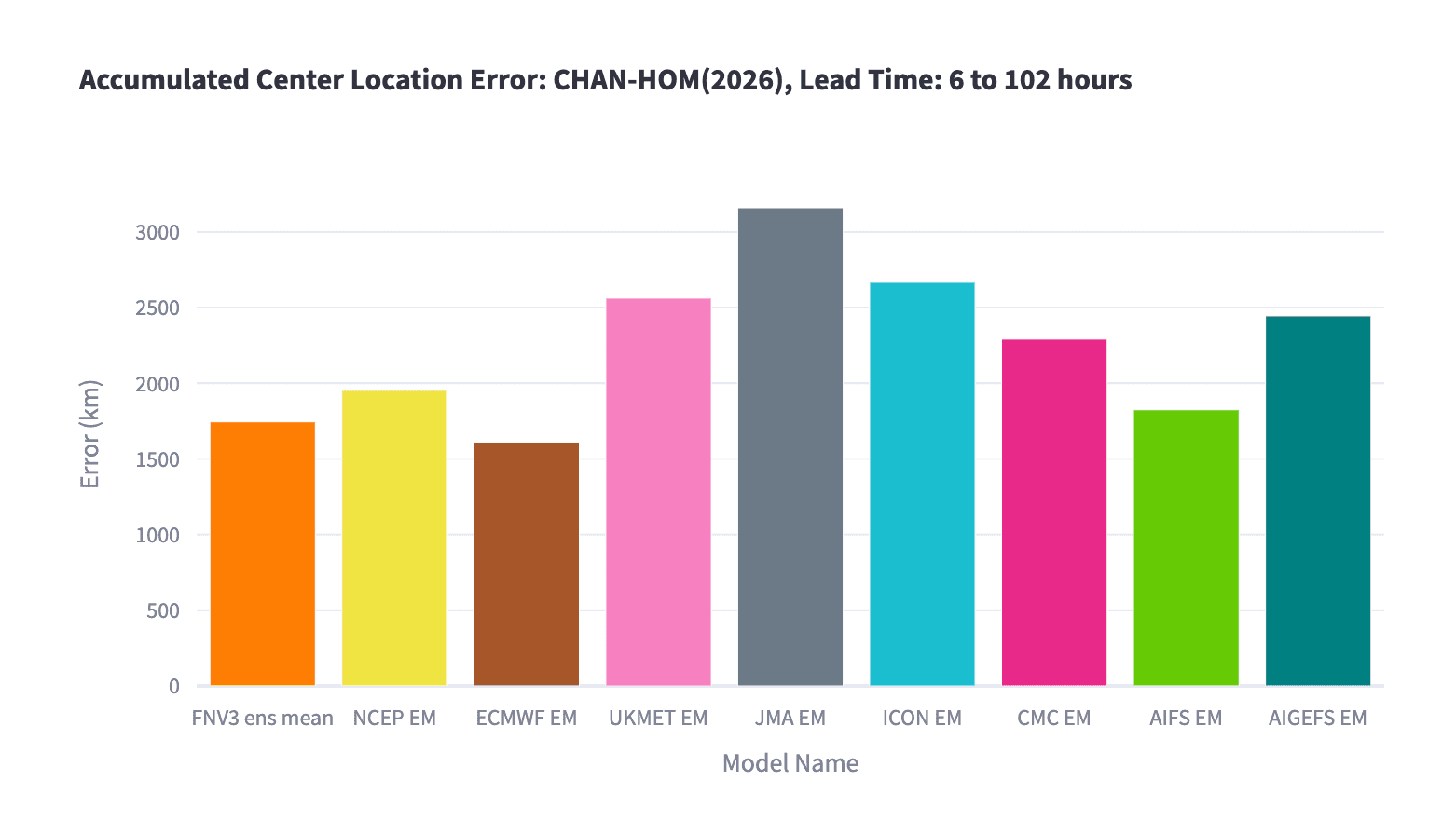
However, comparing the 120-hour cumulative forecast errors in Figure 2 reveals that ECMWF’s traditional physics-based model (ECMWF EM) ultimately achieved the highest overall accuracy. It was followed closely by Google DeepMind’s FNV ens mean, ECMWF’s AI model (AIFS EM), and NCEP EM.
These results indicate that, despite recent industry hype, AI-based models did not demonstrate a definitive advantage over traditional physics-based numerical weather prediction (NWP) models for this specific track forecast.
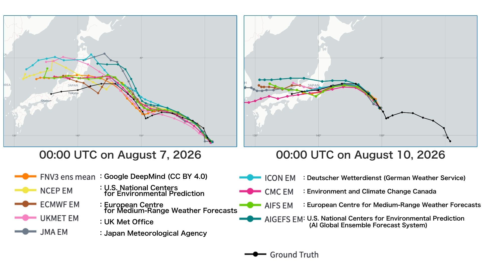
Because Typhoon No. 15 formed along the eastern periphery of the monsoon trough, its wind field and cloud structure were initially poorly organized. During its first few days, the system lacked the conventional characteristics of a mature tropical cyclone. Both AI and physical models historically struggle to maintain high accuracy when confronted with anomalous atmospheric patterns that deviate significantly from established precedents.
The forecast progression in Figure 3 clearly highlights this struggle. At 00:00 UTC on August 7, shortly after formation, all models projected a track considerably farther north than the actual path. As the system’s structure gradually consolidated, the models self-corrected. By 00:00 UTC on August 10, the consensus had largely shifted toward a landfall in Ibaraki Prefecture.
While the high track-forecast accuracy of AI models has commanded significant attention in recent years, this event serves as a prime case study demonstrating that AI models are still susceptible to notable forecast errors when the initial atmospheric structure is highly atypical.
At Weathernews, we utilize a proprietary ensemble forecasting approach that seamlessly integrates our in-house models with top-tier data from global institutions to ensure maximum reliability.
Moving forward, we will continue to rigorously verify the accuracy and biases of a wide spectrum of forecasting tools, including emerging AI-based weather prediction models. By continuously deepening our understanding of how these models behave under anomalous conditions, we remain committed to delivering the most accurate, actionable weather intelligence to our clients.
Share

October 16, 2026
Chiba Torrential Rain Disaster: How Weathernews Protected Employees and Maintained Business Continuity
September 15, 2026
Behind the AI System Delivering Forecasters’ Messages to People Around the World in Just Three Lines
![[2026 Kumamoto Earthquake] How Weathernews LiVE Protects Lives Through User Reports and Expert Analysis](https://gvs.weathernews.jp/wni_blog_media/large_20260914_top_3958fce7fc.png)
September 14, 2026
[2026 Kumamoto Earthquake] How Weathernews LiVE Protects Lives Through User Reports and Expert Analysis