
September 2, 2026
Analysis: The August 2026 Chiba Torrential Rain — Inside a Once-in-10,000-Year Downpour



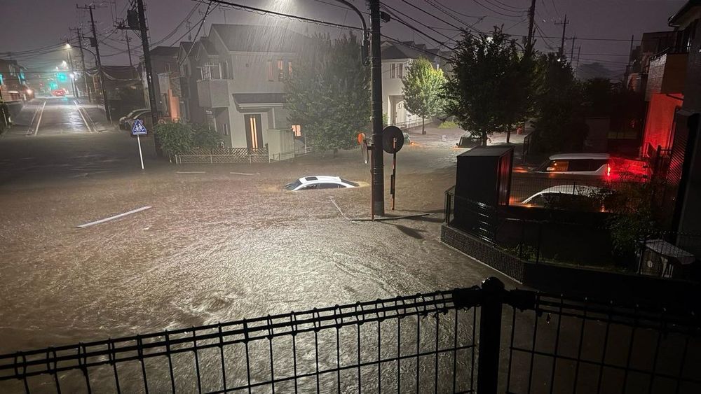
From the evening through the night of Thursday, August 13, 2026, torrential rain battered the Kanto region, particularly Chiba Prefecture. The Japan Meteorological Agency issued its highest-level Emergency Heavy Rain Warning (Level 5). Cities across Chiba Prefecture, including Chiba City and Sakura City, recorded rainfall totals that far exceeded previous records, marking a truly unprecedented emergency.
We extend our deepest sympathies to everyone affected by this disaster, as well as to those who spent an anxious night watching the situation unfold.
With flooded roads, water inundating buildings, and widespread transportation disruptions, the affected areas faced highly tense situations. Just how statistically extraordinary was this rainfall? And why did such intense rain remain concentrated over the exact same area? In this article, Weathernews combines expert meteorological analysis with our proprietary data to uncover the full picture of this severe event.
Record-Breaking Rainfall Exceeding 500 mm in Chiba: A Statistically Almost Unprecedented Event
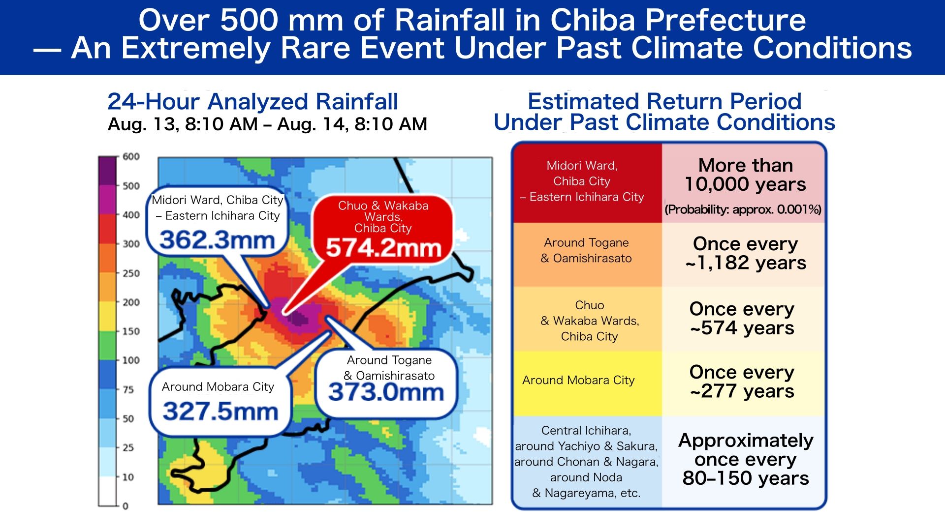
On August 13, a wave of Record-Short-Time Heavy Rainfall Alerts swept across Chiba Prefecture as hourly rainfall hit 100–120 mm. In Chiba City, an astounding 115.0 mm of rain fell in just one hour leading up to 6:48 p.m., driving the 24-hour total past 360 mm. Both figures shattered all local records since observations began in 1966.
The situation rapidly escalated into a severe crisis. Level 5 Emergency Heavy Rain Warnings and Level 5 Emergency Sediment Disaster Warnings—indicating an ongoing or imminent disaster—were issued across a wide expanse of Chiba Prefecture. These alerts covered 14 municipalities: Chiba City, Ichikawa City, Funabashi City, Matsudo City, Sakura City, Narashino City, Kashiwa City, Ichihara City, Yachiyo City, Abiko City, Kamagaya City, Yotsukaido City, Inzai City, and Shiroi City.
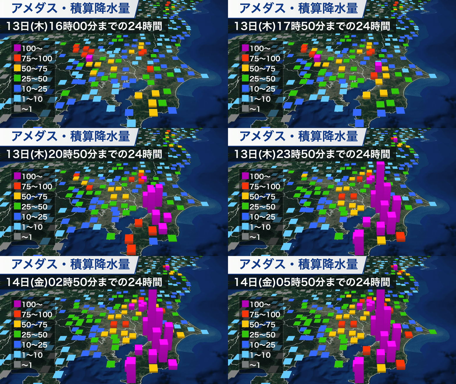
According to Weathernews Inc.’s proprietary analysis, which integrates Japan Meteorological Agency (JMA) AMeDAS data with our own high-density monitoring stations, a maximum 24-hour rainfall total of 574.2 mm was recorded in the area stretching from Midori Ward in Chiba City to eastern Ichihara City.
Based on climate simulation data(*1), the probability of rainfall on this scale occurring is approximately 0.001%. This corresponds to roughly once in 10,000 years, making it a statistically unprecedented event.
*1. Based on data that reconstructs the climate from 1975 to 2014—approximately 39 years centered around 1995—in a virtual environment.
・ Midori Ward, Chiba City – eastern Ichihara City: 574.2 mm (approximately once in 10,000 years / probability: approx. 0.001%) ・ Around Togane and Oamishirasato: 373.0 mm (approximately once in 1,200 years) ・ Around Chuo and Wakaba Wards, Chiba City: 362.3 mm (approximately once in 600 years) ・ Around Mobara City: 327.5 mm (approximately once in 300 years) ・ Other areas across Chiba Prefecture: Approximately once in 80–150 years
These figures underscore the extreme rarity of this event, bringing rainfall on a scale far beyond what residents would typically experience in a lifetime.
Why Did Such Record-Breaking Rainfall Occur?
This historic downpour was the result of multiple atmospheric factors interacting to repeatedly generate and trap rain clouds over the exact same area.
Atmospheric Instability and Low-Level Wind Shear: While a strong cold air mass lingered in the upper atmosphere near the Kinki region, extremely warm, humid air flowed into the lower levels from the edge of the North Pacific High. This created severe atmospheric instability across a broad area. As this warm air collided with surrounding winds, it generated rising air currents (low-level wind shear), acting as an engine for continuous cloud development.
The Passage of an Upper-Level Trough: During the evening, an upper-level trough moved northward. The area ahead of a trough naturally encourages rising air currents, which intensified convection and organized the storms into heavy clusters capable of torrential rain.
The “Back-Building and Side-Building” Phenomenon: Complex vertical wind shear (*2) developed around Chiba Prefecture, featuring easterly to southeasterly winds at lower levels and southerly winds at mid-levels. While individual thunderstorms drifted north to northwest, moist surface air continued to flow in, spawning new thunderstorms on the upwind (southern and eastern) edges of the existing storms. This continuous cycle kept the heavy rain locked over the same location—a structure known as “back-building and side-building.”
*2. Vertical wind shear refers to wind changing speed and direction at different altitudes. Significant differences between surface and upper-atmospheric winds can promote the development of severe thunderstorm clouds.
Capturing the Chiba Rainfall Event: Challenging Forecasting Limits with AI and Proprietary Data
At the Weathernews Forecast Center, our experts analyzed the latest observations and forecast models to identify the severe danger around 3 p.m. By cross-referencing this with live Weather Reports, we successfully issued disaster risk notifications directly to Chiba app users around 4 p.m.
However, as this event demonstrated, it remains notoriously difficult for conventional models to anticipate heavy rain that rapidly intensifies and stalls over a single area, let alone incorporate it directly into standard forecasts.
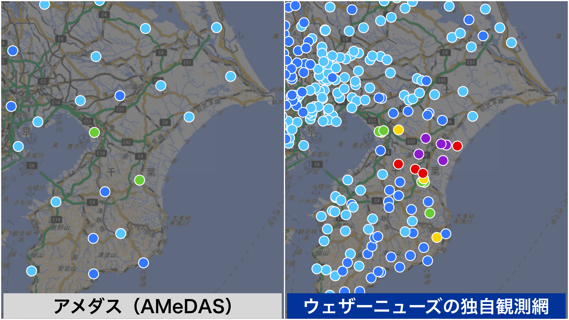
To address this challenge, Weathernews Inc. is developing a proprietary AI forecasting model powered by our highly dense observation data.
During the event, our experimental AI-powered short-term precipitation forecasting system, AI Nowcast, successfully predicted the gradual southeastward movement of the intense rainfall zone.
While further validation is needed, implementing this technology into the Weathernews app will eventually allow us to deliver highly localized warnings—alerting individual users to torrential rain risks several hours in advance. As extreme weather becomes increasingly severe, we are committed to advancing this technology to help people better protect themselves.
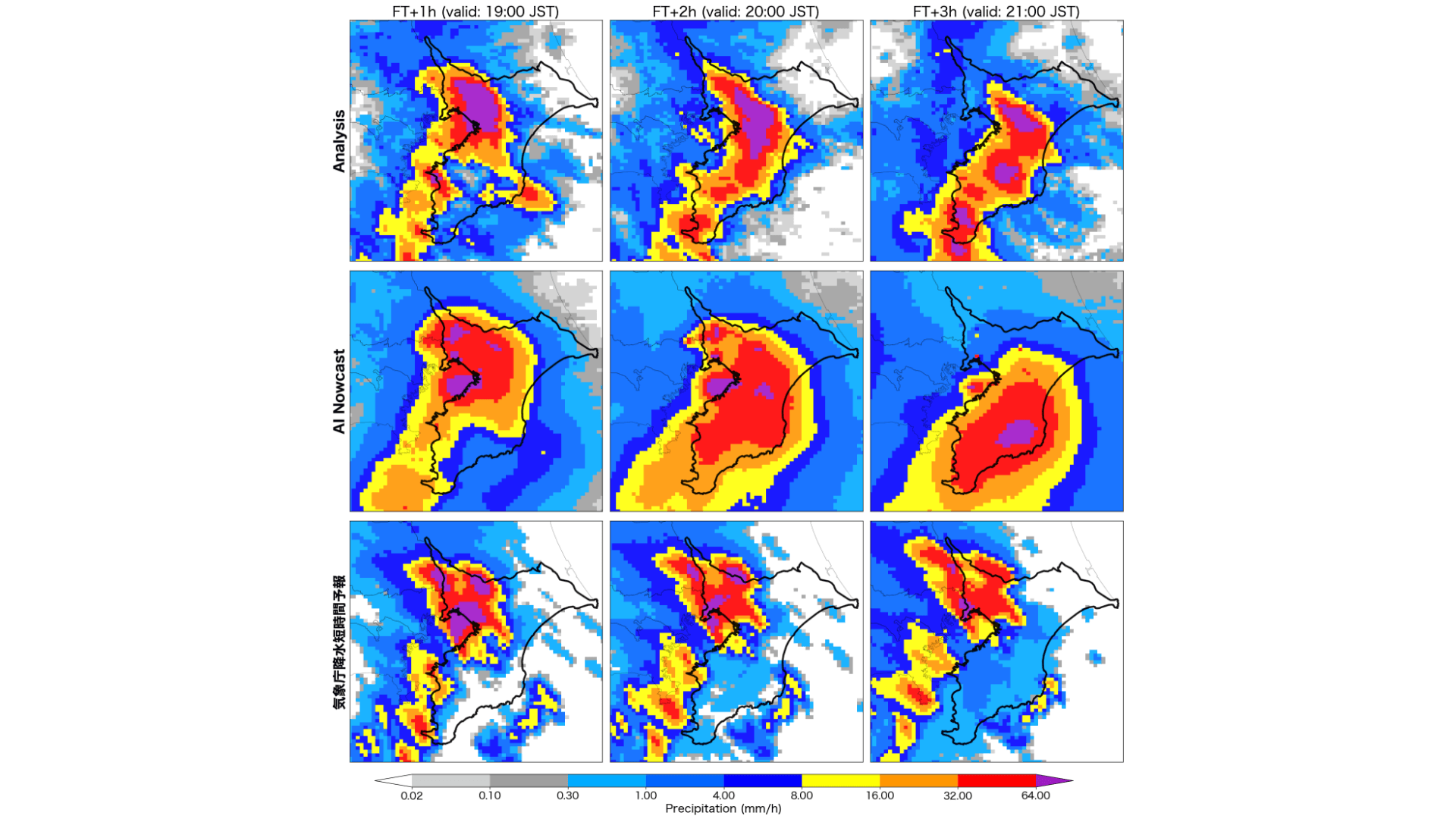
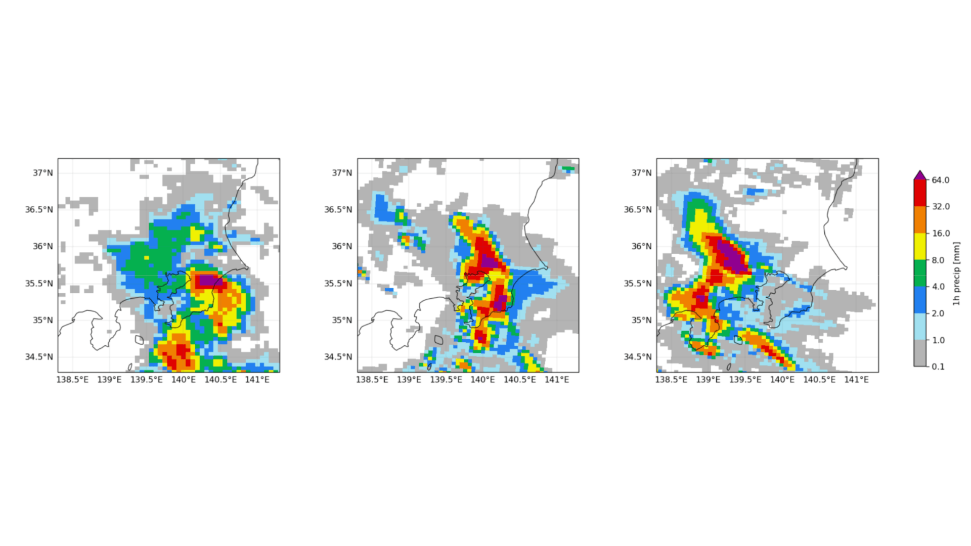
We are also enhancing our existing physics-based forecasting models. Incorporating AI forecast results as additional input has notably improved prediction accuracy. For example, during this event, the model correctly shifted the heavy rain forecast area from western Kanto and the Kofu region directly over Chiba Prefecture, aligning much closer with actual observed conditions.
By utilizing AI and high-performance computing (HPC) to fine-tune model parameters, we are rapidly accelerating improvements to our forecasting system.
One in Two People Were Affected Outside Officially Designated Flood Hazard Zones
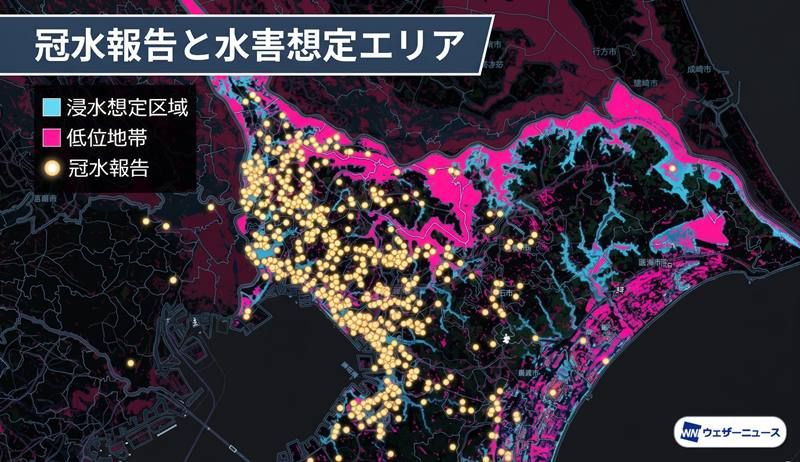
We analyzed the damage caused by the August 2026 Chiba Torrential Rainfall Event by overlaying approximately 10,000 on-the-ground reports submitted through the Weathernews app with digital maps of officially designated flood hazard zones and low-lying areas.
Our analysis revealed that more than half (55.7%) of the reported damage occurred completely outside areas designated by national or local governments as high-risk flood zones.
While historically recognized high-risk areas suffered severe damage, sudden flooding also devastated locations never anticipated to be at risk. This proves that during short, intense bursts of rain, dangerous flood risks exist even in areas situated far from rivers.
As climate change accelerates, extreme weather events that defy historical expectations and conventional risk modeling are becoming increasingly common. Driven by our mission to “be there to help people when it matters most,” Weathernews Inc. will continue combining crowdsourced user reports, dense observation networks, and cutting-edge AI technologies to deliver high-resolution weather intelligence that protects lives and property.
Share
October 16, 2026
Chiba Torrential Rain Disaster: How Weathernews Protected Employees and Maintained Business Continuity

September 15, 2026
Behind the AI System Delivering Forecasters’ Messages to People Around the World in Just Three Lines
![[2026 Kumamoto Earthquake] How Weathernews LiVE Protects Lives Through User Reports and Expert Analysis](https://gvs.weathernews.jp/wni_blog_media/large_20260914_top_3958fce7fc.png)
September 14, 2026
[2026 Kumamoto Earthquake] How Weathernews LiVE Protects Lives Through User Reports and Expert Analysis