December 5, 2025
Visualizing Wildfire Risk: Understanding Where and How Fires Spread ~ Protecting Communities and Natural Resources Through Better Risk Management ~
In recent years, record-breaking heatwaves and extreme dry conditions driven by global warming have pushed wildfire risk to unprecedented levels. According to the World Resources Institute, global forest area lost to fire was approximately 4 million hectares 20 years ago, but reached roughly 12 million hectares in 2023—nearly a threefold increase1.
In Japan, where forests cover approximately 67% of the land, wildfires are by no means someone else's problem. Strengthening community resilience to protect lives and property from these unpredictable disasters has become an urgent imperative.
To help address this critical challenge, Weathernews has developed forecasting technology that visualizes areas at high risk for fire ignition and spread. In this article, we speak with Mayuko Yoshikawa from the Weathernews Forecast Center about the technology and service behind our new "Wildfire Advisory," which makes wildfire risk visible in real time.
Wildfire Advisory Service Launches in 2026: Ofunato Mountain Fire Catalyzes Accelerated Wildfire Prevention Efforts
In February 2025, a large-scale wildfire broke out in Ofunato City, Iwate Prefecture, causing extensive damage. Reports indicate that abnormal dryness within the forest and strong winds contributed to the fire's spread2. In response, Weathernews began advancing our technical research to better visualize wildfire risk.
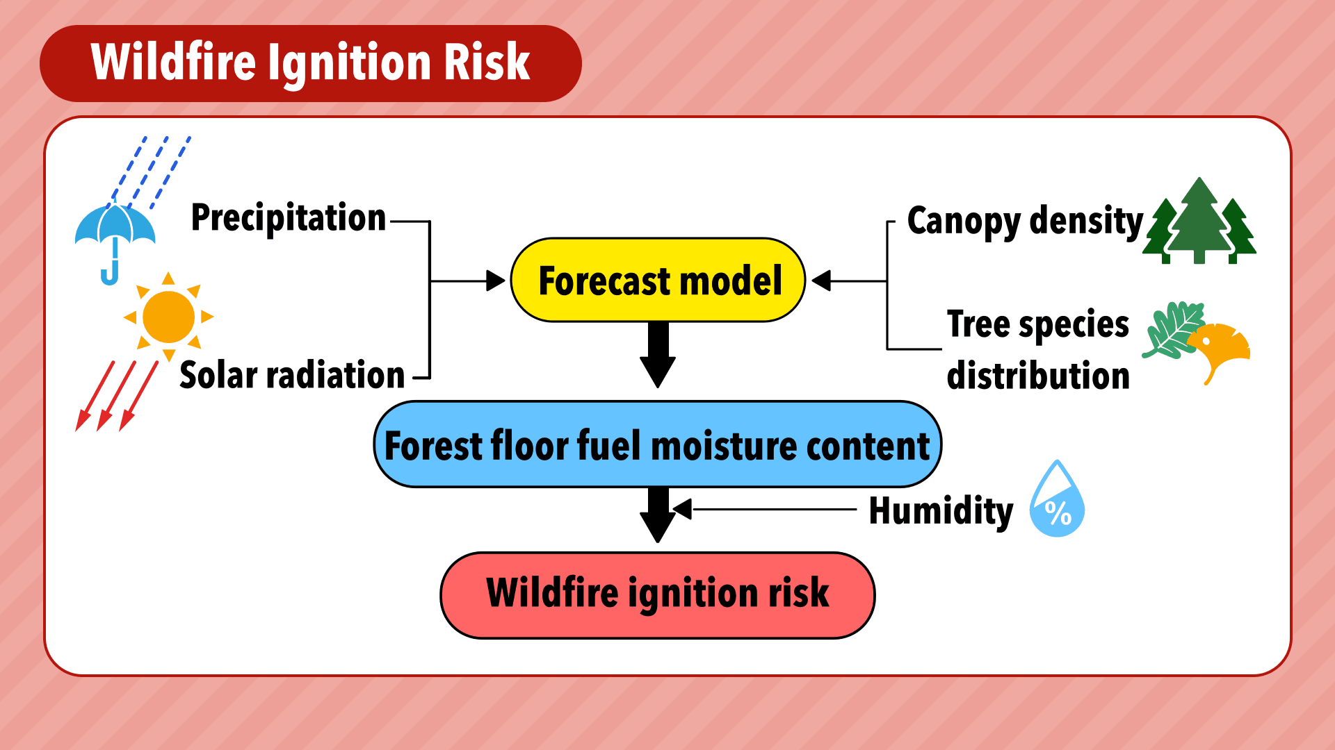
Our first focus was visualizing ignition risk—that is, when and where forests become dry enough to ignite. The key indicator for ignition risk is "forest floor fuel moisture content," which represents the degree of forest dryness. This can be calculated from precipitation and solar radiation.
To more accurately represent forest conditions, we incorporate tree species (such as evergreens) into our prediction logic. We also use satellite imagery to integrate canopy density (the ratio of vegetation visible from above) into our model, which helps express how readily the forest floor retains moisture.
Japan's summers are humid, creating an environment where fires are less likely to occur. However, if we rely solely on precipitation and solar radiation, the ignition risk can become overly sensitive. To account for Japan's unique climate, we factor in humidity levels from the preceding several days. This approach prevents excessive increases in predicted ignition risk and improves forecast accuracy.
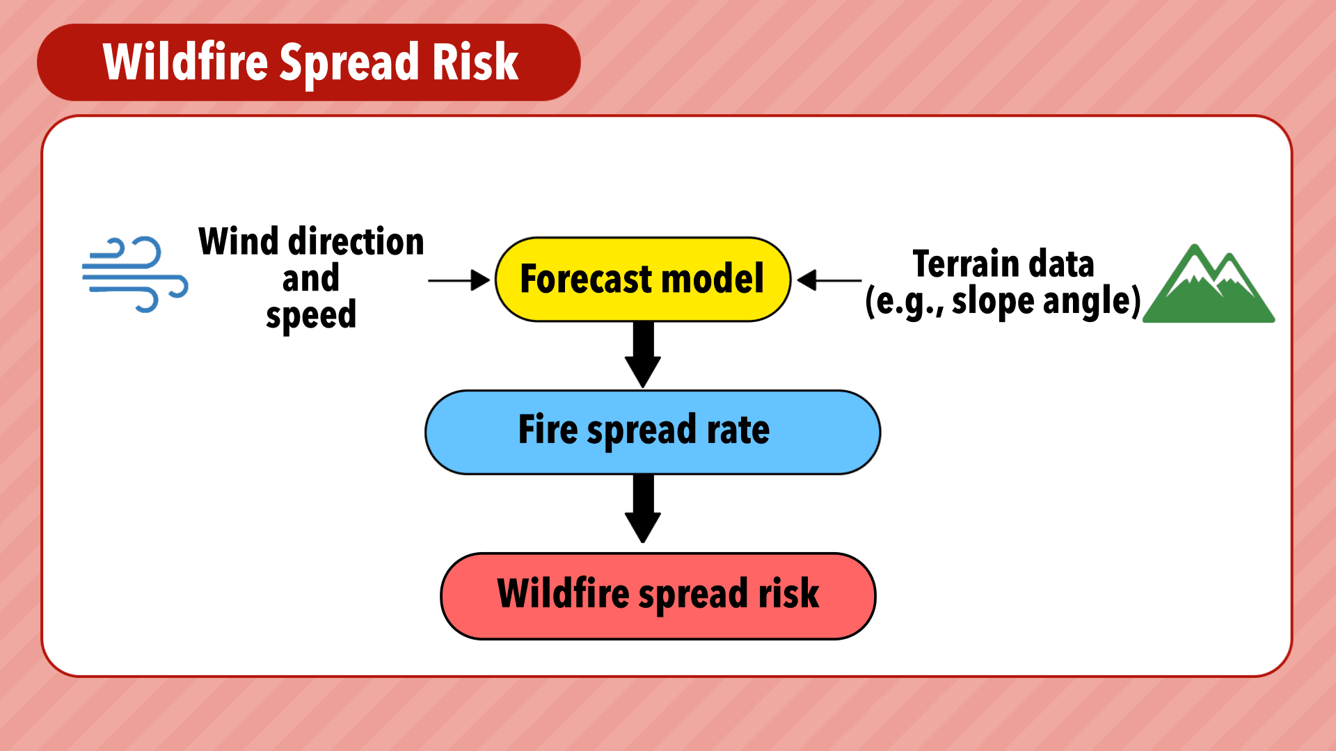
Our next focus was visualizing spread risk—critical information for firefighting operations that shows where and how rapidly a fire could expand once ignited.
The most important factor in predicting spread risk is accurately calculating how wind affects fire behavior. For our prediction model, we adopted the Rothermel fire spread equation developed by Richard Rothermel, a globally trusted model for estimating wildfire propagation speed (hereafter referred to as the Rothermel model).
The Rothermel model considers not only wind speed but also slope angle. Updrafts generated by the fire itself (known as fire-induced winds) intensify along mountain slopes, accelerating fire spread as effectively as increased wind speed would. By factoring in how slope amplifies spread, the model predicts how many meters per hour a fire will advance, enabling more accurate assessment of spread risk.
The original Rothermel model includes forest floor fuel conditions in its calculations, but we simplified this aspect for practical implementation. Our goal was to create a system that, when used together with the ignition risk model described earlier, provides comprehensive yet straightforward information. We wanted users to easily understand not just the risk level, but also why the risk is elevated—making the system both accessible and actionable for decision-makers.
Exceptionally High Risk Conditions: The November 18, 2025 Oita Sagaseki Fire
On November 18, 2025, a large-scale fire broke out in a residential area of Sagaseki, Oita City, causing devastating damage with flames spreading to over 180 homes3. We used our proprietary prediction models to assess just how elevated the risk levels were at the time of the fire.
Our analysis of conditions in Oita City revealed that by 9:00 a.m. on November 18, forest floor fuel moisture content had fallen below 20%, placing ignition risk in the "high" category. By approximately 3:00 p.m., the model predicted spread speeds of 1,000–2,000 meters per hour, indicating that spread risk had also reached "high" levels.
To put these spread speeds in perspective, consider the major Ashikaga wildfire from February 2021. That fire scorched approximately 167 hectares, took 23 days to fully extinguish, and analysis showed spread speeds of around 1,200 m/h at the time.
The conditions during the Oita fire were comparable to—or potentially even more dangerous than—those during the Ashikaga incident in terms of spread potential.
Delivering Wildfire Risk Intelligence to Local Governments and Fire Departments
In response to the February 2025 mountain fire in Ofunato City, Iwate Prefecture, Japan established a new "Wildfire Advisory" system, set to begin nationwide operations in January 2026. Under this system, municipalities will issue advisories when dry conditions or strong winds elevate wildfire risk, calling on residents to exercise caution when using open flames outdoors.
However, discussions with fire department officials have revealed practical challenges in implementation. Many express concerns about establishing operational protocols, coordinating across departments, and effectively communicating warnings to the public.
To help address these needs, Weathernews has launched a "Wildfire Risk"4 service through Weathernews for Business5, our corporate solution platform. This tool is designed to support local governments and fire departments as they navigate the complexities of this new advisory system.
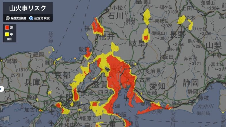
Within Weathernews for Business, users can view detailed assessments of both ignition risk and spread risk.
Ignition Risk: Effective humidity ≤ 60% Forest floor fuel moisture content 20–30% → Medium Below 20% → High
Spread Risk: Spread speed 350–400 m/h → Medium Above 400 m/h → High
These forecasts leverage Weathernews' proprietary high-resolution prediction model, providing nationwide coverage at 1-kilometer grid resolution. Risk levels are displayed visually on an interactive map, and when conditions deteriorate in monitored areas, the system is designed to send instant push notifications to smartphones in a future release—enabling local governments and fire departments to respond quickly and decisively.
Additionally, the platform provides assessment results that align with the Fire and Disaster Management Agency's recommended criteria for issuing Wildfire Advisories and Warnings6, making it easier for municipalities to make informed decisions about when to activate the official advisory system.
Rising Wildfire Risk Worldwide: Building a Society that Protects Lives and Nature
The wildfire risk prediction system we've developed draws on our expertise in remote sensing for forest monitoring combined with advanced forecasting techniques. Our hope is that this technology can contribute, even in a small way, to building a society better equipped to protect human lives and preserve natural ecosystems. Looking ahead, Weathernews is also developing high-precision satellite-based detection technology capable of identifying active wildfires in real time—adding another critical layer to wildfire response capabilities.
Climate change is driving an increase in extreme weather events while simultaneously intensifying concerns about water scarcity and prolonged drought. When severe dry conditions persist, any wildfire that does ignite has the potential to become far more destructive. This makes wildfires one of the climate-related hazards we can expect to see escalate in the years ahead.
Weathernews operates at the intersection of daily weather forecasting and long-term climate risk assessment, quantifying threats that span from immediate to decades into the future. By leveraging this unique dual perspective, we will continue developing new technologies and implementing practical solutions—not just across Japan, but around the world—to help communities prepare for and respond to the growing challenges posed by our changing climate.

Footnotes
- 1:The Latest Data Confirms: Forest Fires Are Getting Worse ↩︎
- 2:大船渡市林野火災を踏まえた消防防災対策のあり方に関する検討会報告書概要 ↩︎
- 3:Japan's biggest fire in nearly 50 years ravages 170 buildings, kills one, 大分市佐賀関の大規模火災、無人島・蔦島も鎮火…残っていた熱源なくなる ↩︎
- 4:October 16, 2025 – Launch of Wildland Fire Risk Forecasting Service for Municipalities and Fire Departments ↩︎
- 5:Professional weather services for business Weathernews for business ↩︎
- 6:Regarding the Revision of the “Guidelines on the Prevention and Firefighting of Forest and Wildland Fires” ↩︎
Share
March 27, 2026
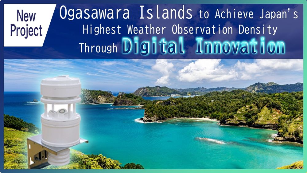
Ogasawara Islands to Achieve Japan's Highest Weather Observation Density Through Digital Innovation

March 16, 2026
Japan's Most Comprehensive Cherry Blossom Forecast: How Our Proprietary Bloom Prediction Model Leverages User-Generated Photos and High-Precision Data Across 1,400 Locations
March 13, 2026
How TV Stations Are Transforming Weather Coverage A New Content Solution Helping Broadcasters Navigate Weather and Disaster Reporting