January 16, 2026
Ougiyama Wildfire:Prolonged Battle Likely Before Full Containment as Burned Area Exceeds 200 Hectares
The forest fire burning in Yamanashi Prefecture remains uncontained and continues to expand. The affected area has already surpassed 200 hectares, exceeding the scale of the 2021 Ashikaga wildfire.
Why Has the Fire Not Been Fully Contained? Three Key Challenges at the Scene
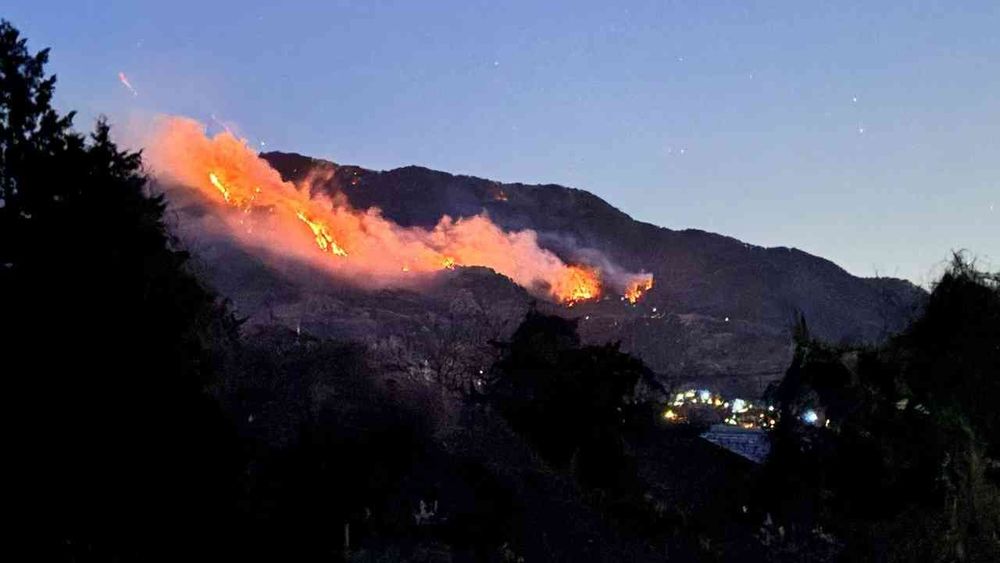
The wildfire that ignited on Mount Ougiyama in Yamanashi Prefecture on the morning of January 8 continues to burn, with the affected area now expanding to approximately 230 hectares. Despite intensified aerial firefighting operations, including helicopter water drops, full containment has yet to be achieved.
On January 11, flames advanced to within approximately 30 meters of nearby residential areas. However, thanks to aggressive firefighting response and timely evacuation advisories, no injuries have been reported to date. From a meteorological standpoint, three primary factors have hindered containment efforts:
The first factor is strong winds. Immediately following ignition, powerful winds rapidly accelerated the fire's spread along mountain ridges. These conditions have persisted due to a winter pressure pattern, continuing to fuel the fire's expansion even after the initial outbreak.
The second factor is extreme dryness. The Mount Ougiyama area has received no precipitation since January 3. Winter's dry air has left fallen leaves and forest floors severely desiccated, creating highly combustible conditions. With no rainfall since the fire began, aerial water drops remain the only viable suppression method.
The third factor is steep terrain. Mount Ougiyama's challenging topography, characterized by steep slopes, severely limits ground crew access. This forces heavy reliance on time-intensive aerial operations. Additionally, the steep inclines accelerate fire spread across the landscape.
Strongest Winter Pressure Pattern of the Season to Sustain Dry Conditions; Heightened Risk of New Wildfires
According to the Weathernews Forecast Center, there is no forecast for significant precipitation in eastern Yamanashi Prefecture over the next two weeks, meaning rainfall or snowfall is unlikely to contribute to extinguishing the fire. While some forecast models suggest a low-pressure system may pass through around January 26 and bring snow, accumulation is expected to be minimal.
Starting January 21, the season's strongest winter pressure pattern is forecast to develop. This will bring exceptionally dry air and strong winds to the Kanto–Koshin region, significantly elevating the risk of additional wildfire outbreaks.
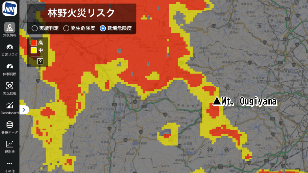
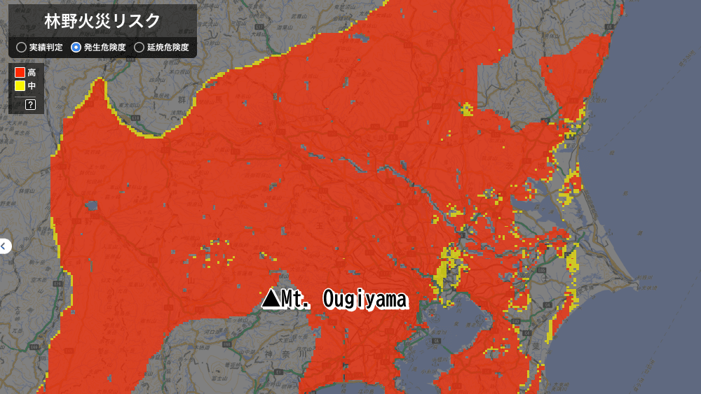
Visualizing Wildfire Ignition and Spread Risk with the “Forest Fire Risk” Service
Weathernews provides the “Forest Fire Risk” content through its corporate weather information service, Weathernews for Business, which visualizes the risk of wildfire ignition and spread12.
Based on the Forestry Agency’s system and enhanced with Weathernews’ proprietary improvements, this service analyzes conditions nationwide at a high resolution of 1-kilometer grids and provides hourly forecasts up to 72 hours ahead. It offers two key indicators primarily for local governments and fire departments:
Ignition Risk, which assesses how easily fires can start based on dryness levels of fallen leaves and other surface fuels
Spread Risk, which estimates the speed of fire spread using wind speed and topographical data
Forecasts issued on January 7 indicated a “high” forest fire risk around Mount Ougiyama on January 8, highlighting the extremely dangerous conditions at the time.
Weathernews remains committed to supporting firefighting authorities through our Forest Fire Risk service, enabling data-driven wildfire advisories, warnings, and patrol planning. When wildfires occur, early identification of high-risk spread areas helps authorities prioritize firefighting resources and make informed evacuation decisions—ultimately accelerating response times and minimizing wildfire damage.
Footnotes
Share

March 27, 2026
Ogasawara Islands to Achieve Japan's Highest Weather Observation Density Through Digital Innovation

March 16, 2026
Japan's Most Comprehensive Cherry Blossom Forecast: How Our Proprietary Bloom Prediction Model Leverages User-Generated Photos and High-Precision Data Across 1,400 Locations

March 13, 2026
How TV Stations Are Transforming Weather Coverage A New Content Solution Helping Broadcasters Navigate Weather and Disaster Reporting