October 7, 2025
Typhoon No. 18 (Ragasa) Devastates Asia: Assessing Track and Rainfall Forecast Accuracy
Meteorological Overview
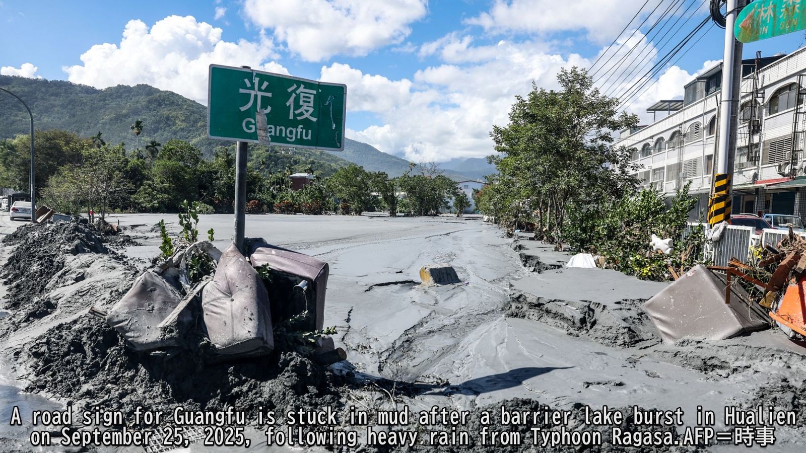
Typhoon Ragasa (No. 18) formed east of the Philippines on September 18, 2025. The storm rapidly intensified into a violent typhoon and maintained its strength as it passed between the Philippines and Taiwan before continuing westward into the South China Sea. The typhoon made landfall in southern China on September 24 and subsequently weakened, downgrading to a tropical depression by September 25. Both the Philippines and Taiwan experienced severe impacts from the powerful storm, with torrential rainfall causing widespread disasters. In the Philippines, Typhoon Ragasa claimed 11 lives1. Taiwan's Hualien County faced particularly devastating consequences when a landslide-dammed lake in the mountainous region collapsed, triggering catastrophic flooding that resulted in 14 fatalities and 512 people still missing(as of September 24)2.
Review of Track Forecast Accuracy
To assess the accuracy of Typhoon No. 18's track forecasts, we analyzed predictions from eight global forecasting models. Figure 1 displays the predicted tracks from each model as of 00:00 UTC on September 17, 2025. While all models correctly forecasted the general westward trajectory passing between the Philippines and Taiwan—which matched the storm's actual path—several models predicted a track that was positioned farther north than what actually occurred, especially in the area east of the Philippines.
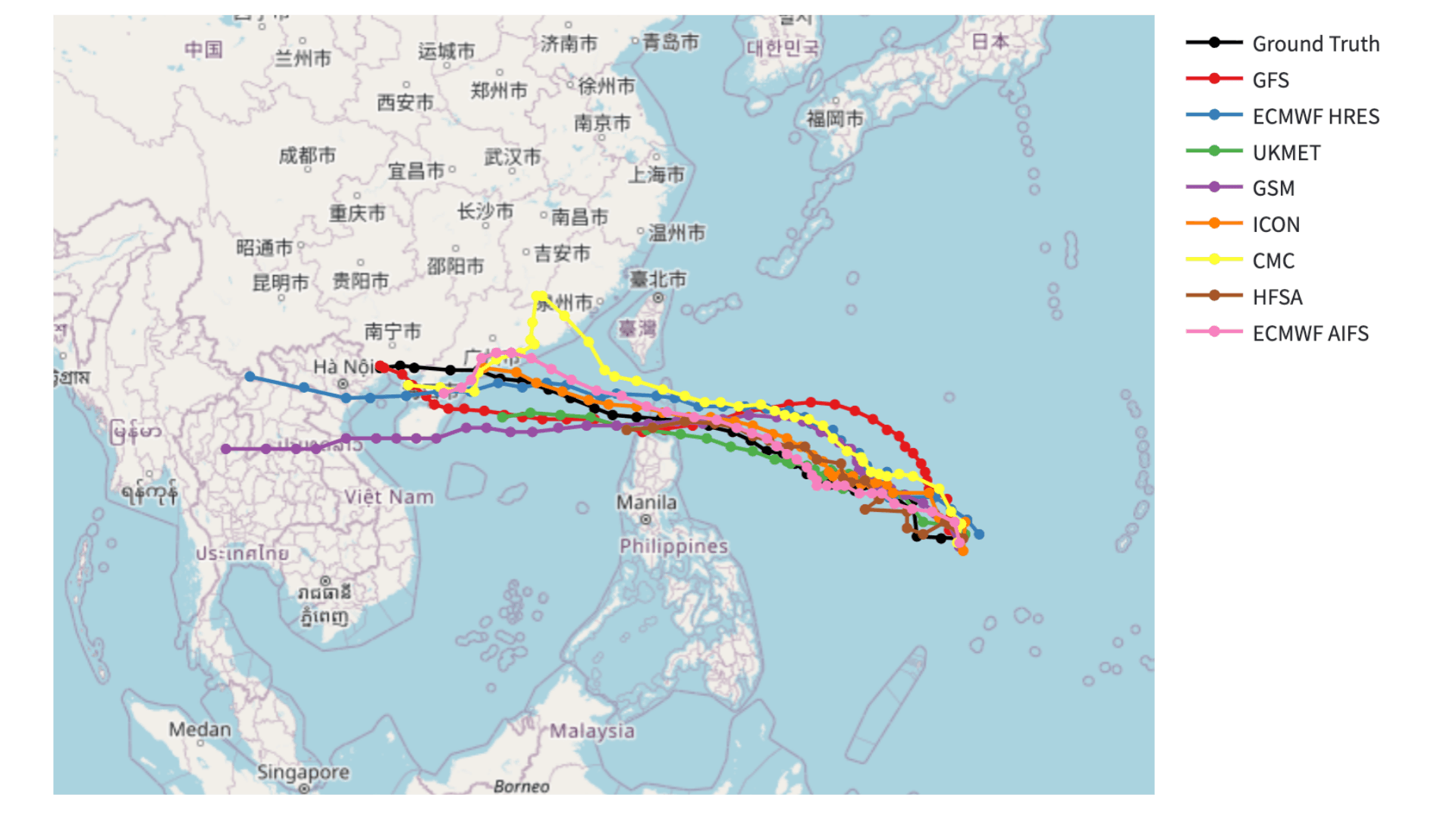
GFS (NCEP): U.S. National Centers for Environmental Prediction ECMWF: European Centre for Medium-Range Weather Forecasts UKMET: UK Met Office GSM (JMA): Japan Meteorological Agency CMC: Canadian Meteorological Centre HFSA: U.S. National Oceanic and Atmospheric Administration ICON (DWD): Deutscher Wetterdienst (Germany)
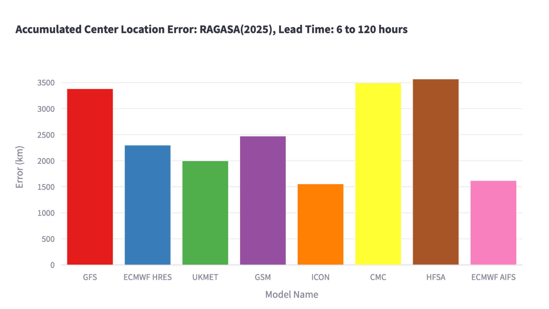
Figure 2 illustrates the relationship between forecast lead time and positional accuracy of the typhoon's center. The horizontal axis represents forecast lead time in hours, while the vertical axis shows the distance between predicted and actual positions. For forecasts extending up to 120 hours, two models demonstrated superior performance: the Deutscher Wetterdienst model (ICON) and ECMWF's AI-based forecasting system (AIFS) both maintained positional errors below approximately 150 km, significantly outperforming the other models. When examining cumulative forecast errors across the entire 120-hour period, ICON achieved the highest accuracy with the smallest overall error, closely followed by ECMWF's AIFS system (Figure 3).
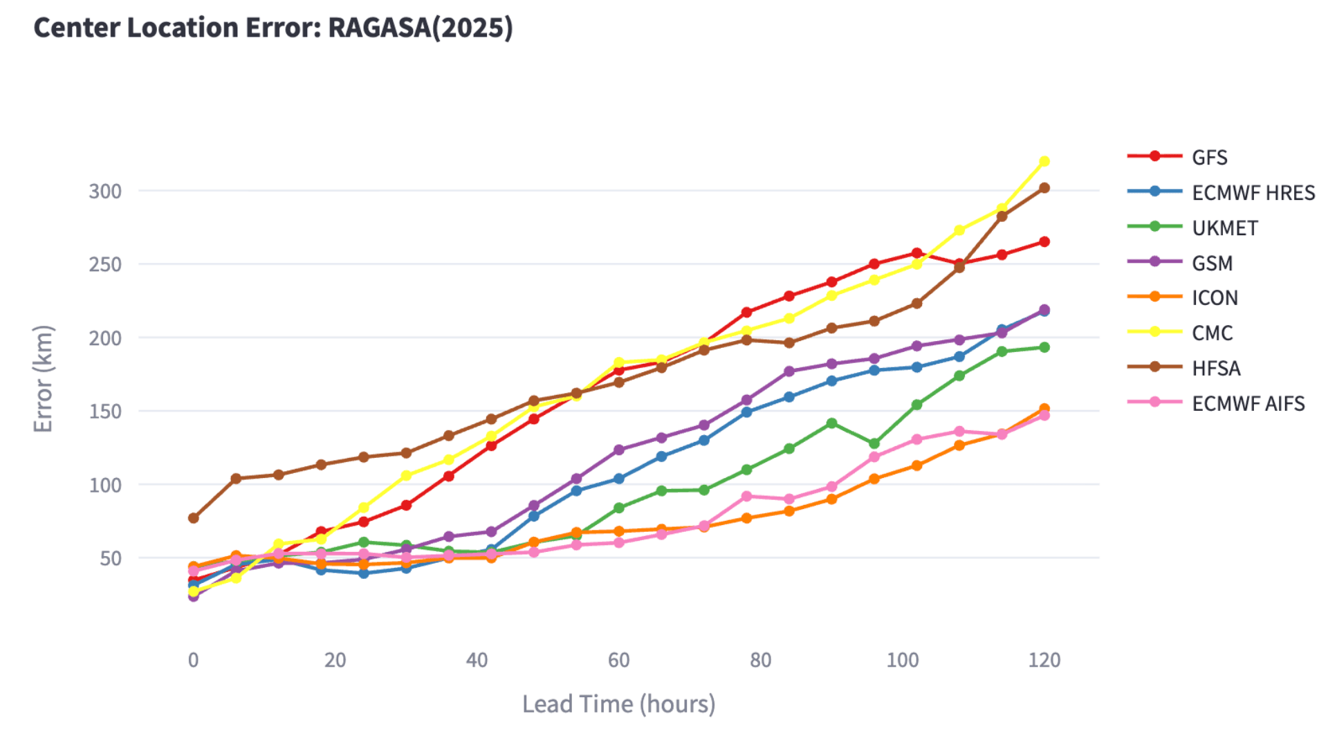
GFS (NCEP): U.S. National Centers for Environmental Prediction ECMWF: European Centre for Medium-Range Weather Forecasts UKMET: UK Met Office GSM (JMA): Japan Meteorological Agency CMC: Canadian Meteorological Centre HFSA (NOAA): U.S. National Oceanic and Atmospheric Administration ICON (DWD): Deutscher Wetterdienst
Rainfall Forecast Verification
To further evaluate forecast performance, we analyzed rainfall predictions from multiple global meteorological models for the Philippines and Taiwan, where severe flooding occurred. In Baguio, Philippines, weather stations recorded 327 mm of rainfall during the 24-hour period from 00:00 UTC on September 22 to 00:00 UTC on September 23. Among all the models, ECMWF's AI-based forecasting system (AIFS) provided the most accurate prediction at 190 mm. However, even this best-performing model significantly underestimated the actual rainfall total of 327 mm (Figure 4).
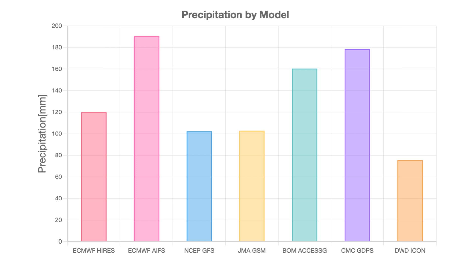
Base time: 00:00 UTC, September 21, 2025 (SYNOP station: Baguio) ECMWF: European Centre for Medium-Range Weather Forecasts
NCEP: U.S. National Centers for Environmental Prediction JMA: Japan Meteorological Agency BOM: Australian Bureau of Meteorology CMC: Canadian Meteorological Centre DWD: Deutscher Wetterdienst
According to Taiwan's Central Weather Administration, Typhoon No. 18 brought sustained heavy rainfall across the island, with some areas receiving up to 1,000 mm over three days. In Hualien County, where catastrophic flooding occurred, rainfall reached its peak intensity between 16:00 UTC on September 22 and 16:00 UTC on September 23, with over 500 mm falling within this 24-hour period. Among the forecasting models, the NCEP GFS model provided the highest rainfall prediction for this period at over 200 mm. Several other models also forecasted amounts approaching 200 mm, indicating they recognized the potential for significant heavy rainfall. However, none of the models successfully captured the extreme rainfall totals that actually occurred (Figure 5).
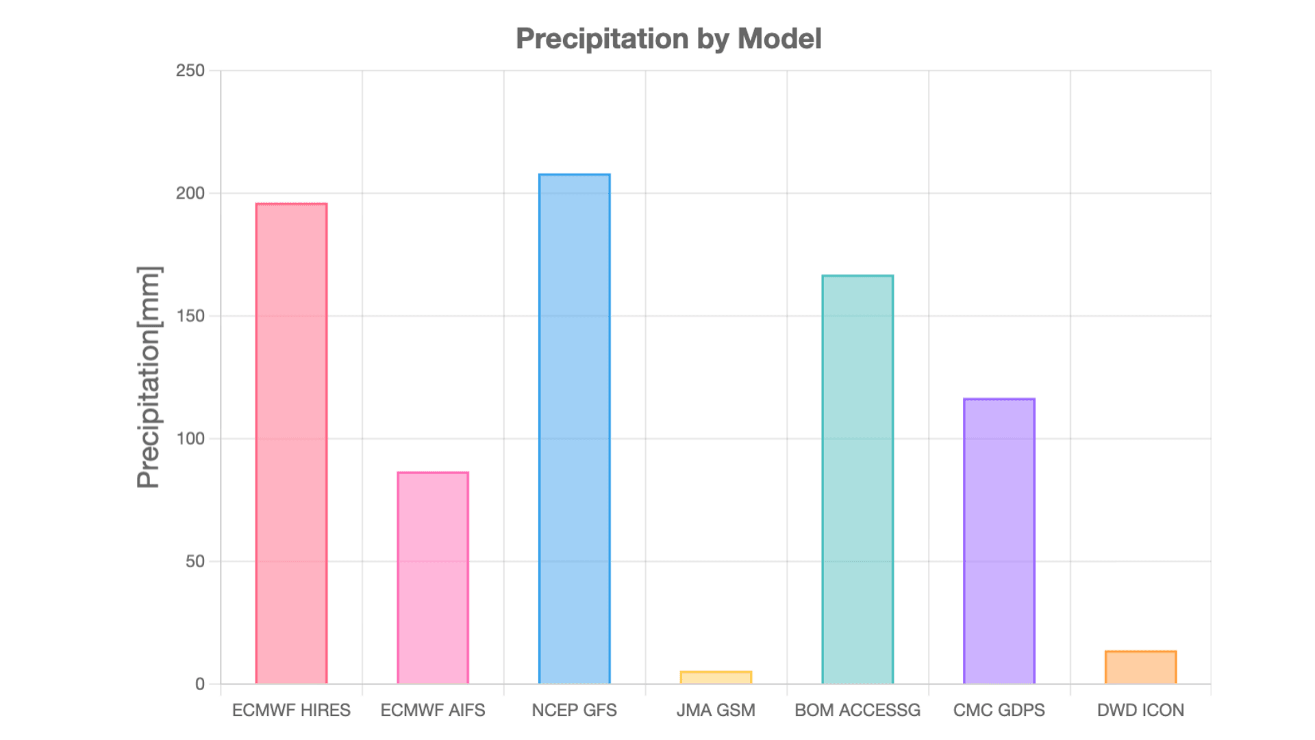
ECMWF: European Centre for Medium-Range Weather Forecasts NCEP: U.S. National Centers for Environmental Prediction JMA: Japan Meteorological Agency BOM: Australian Bureau of Meteorology CMC: Canadian Meteorological Centre DWD: Deutscher Wetterdienst
At Weathernews, we are committed to delivering highly accurate forecasts by combining our proprietary prediction models with ensemble forecasting techniques that integrate data from multiple global models. Through ongoing analysis of model performance—including emerging AI-based forecasting systems—we continuously work to better understand each model's strengths and limitations. This approach enables us to provide our users with more reliable and precise weather information.
Footnotes
Share

March 13, 2026
How TV Stations Are Transforming Weather Coverage A New Content Solution Helping Broadcasters Navigate Weather and Disaster Reporting

March 6, 2026
Weathernews Launches Comprehensive BCP Service: Emergency Confirmation Powered by Weather Expertise

March 6, 2026
Taking on Japan's Most Widespread Health Challenge with Data and Passion: Why Weathernews Continues to Strengthen Its Pollen Information and the Commitment Behind It