September 4, 2025
Heavy Rain and Flooding in Vietnam: Evaluating the Forecast Accuracy of Typhoon 13
Meteorological Overview
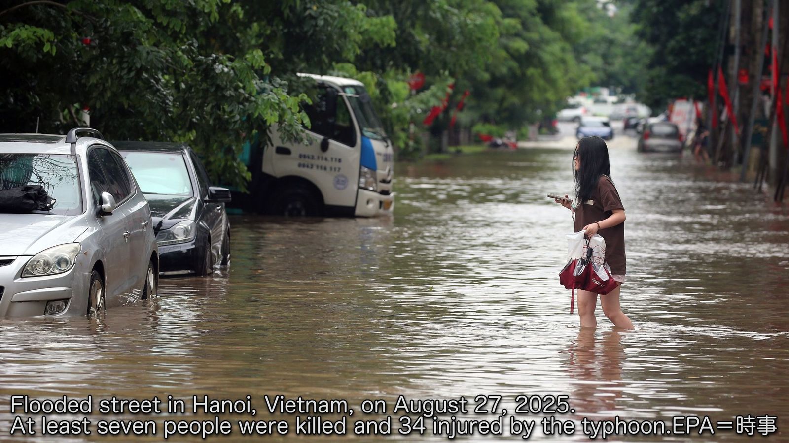
Typhoon KAJIKI (No. 13) developed over the South China Sea and gained strength as it tracked westward toward the Vietnamese coast. The storm made landfall in central Vietnam on August 25 as a powerful weather system before quickly losing intensity as it moved inland. By August 26 at 06:00 UTC, KAJIKI had weakened to a tropical depression over Laos.
The typhoon brought significant rainfall across the region, with Ha Tinh Province experiencing the heaviest impacts. Some areas recorded over 150mm of precipitation. The severe weather conditions resulted in tragic consequences for Ha Tinh Province, including three fatalities and widespread property damage. Local authorities reported 144 homes were flooded and 621 houses sustained damage. The storm also caused power outages throughout the area and generated dangerous storm surges that led to coastal flooding.1
Review of Forecast Accuracy
To evaluate the track forecast of Typhoon No. 13, we compared eight forecasting models. Figure 1 shows the predicted tracks from each model three days before the typhoon made landfall in Vietnam. Most models forecasted a westward track leading to landfall along the Vietnamese coast.
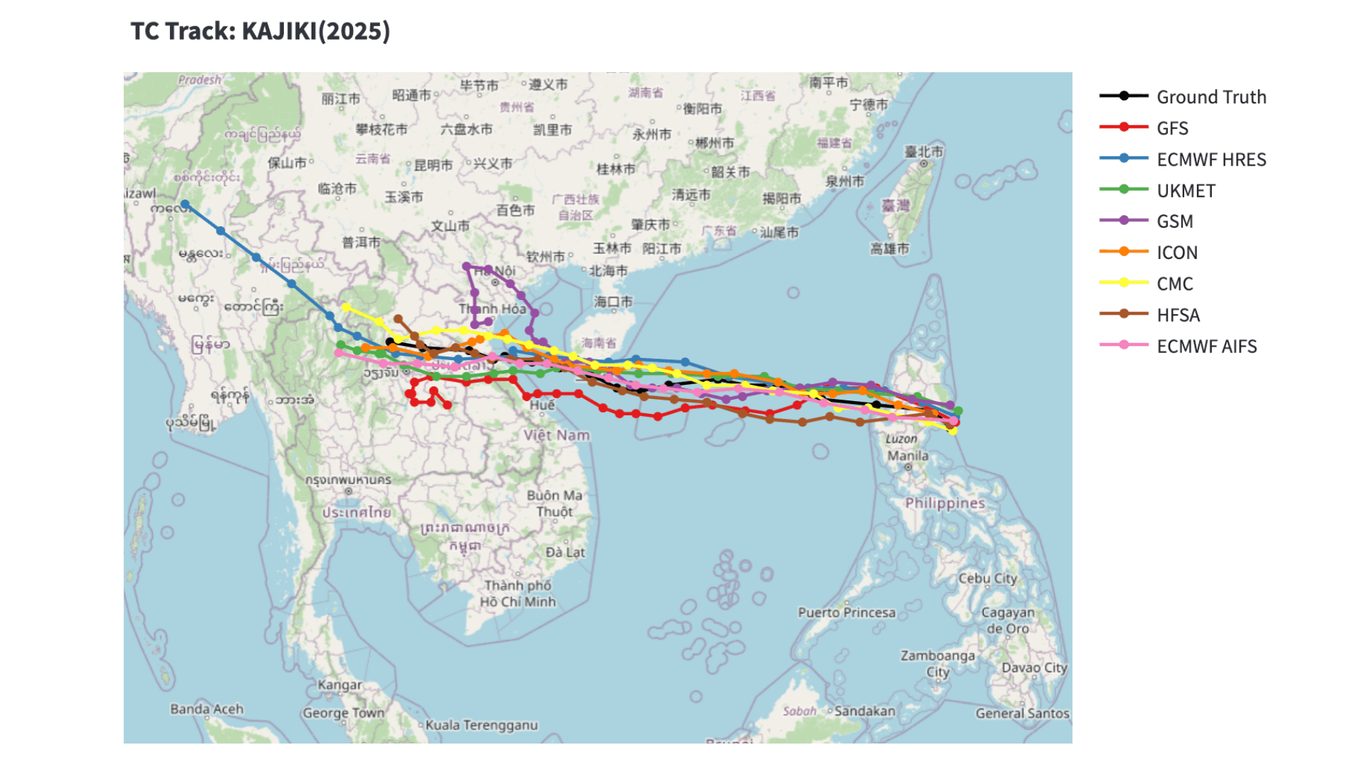
GFS (NCEP): U.S. National Centers for Environmental Prediction ECMWF: European Centre for Medium-Range Weather Forecasts UKMET: UK Met Office GSM (JMA): Japan Meteorological Agency CMC: Canadian Meteorological Centre HFSA (NOAA): U.S. National Oceanic and Atmospheric Administration ICON (DWD): Deutscher Wetterdienst (Germany)
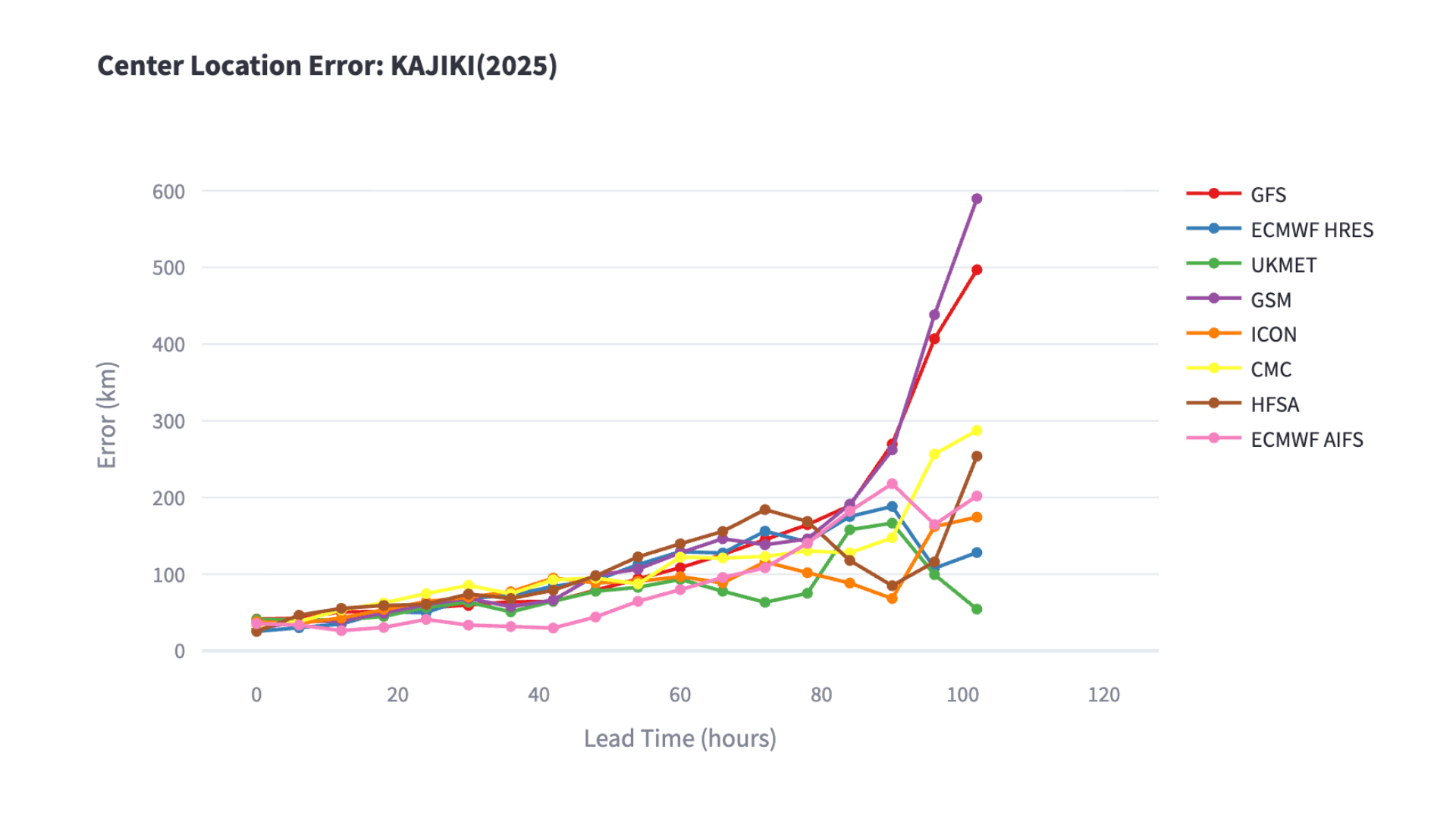
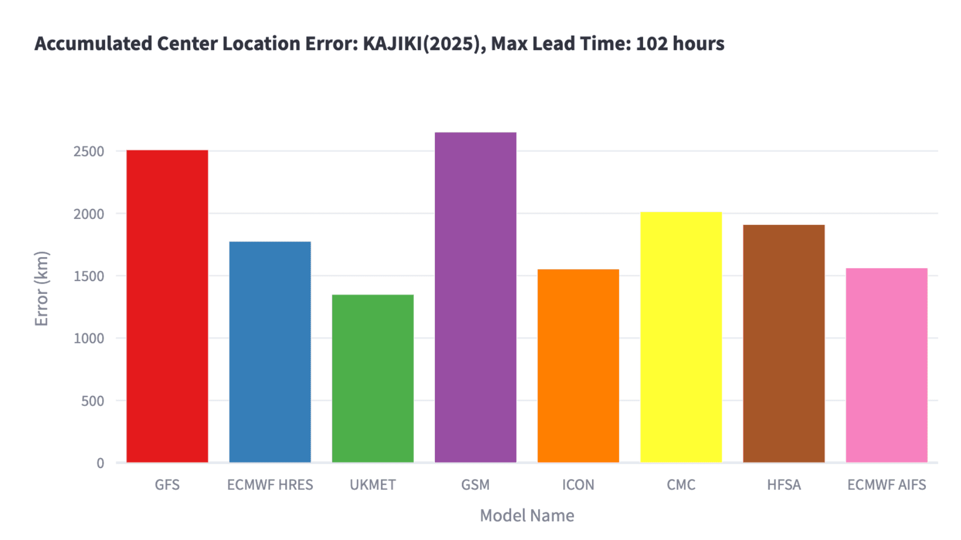
Figure 2 presents the error between predicted and observed typhoon center positions. The horizontal axis indicates forecast lead time, while the vertical axis shows positional error. For forecasts up to 48 hours ahead, ECMWF’s AI-based weather model (AIFS) maintained errors under 50 km, outperforming other models. When comparing cumulative forecast errors up to 102 hours, the UK Met Office model had the smallest overall error, followed by DWD and AIFS (Figure 3).
Rainfall Forecast Verification
According to the Vietnam Meteorological Agency, the highest rainfall was recorded in Son Kim, Ha Tinh Province, reaching 211.1 mm between 12:00 and 20:00 UTC on August 25 2. Weathernews compared the precipitation forecasts of eight global models for this heavy rainfall event. As of 00:00 UTC on August 25, many models indicated the possibility of over 100 mm of rainfall between 12:00 UTC on August 25 and 00:00 UTC on August 26. The highest forecasted rainfall amounts came from the NCEP and JMA models, both predicting 193 mm. Although slightly below the observed 211.1 mm, the forecasts achieved accuracy within a 10% margin (Figure 4).
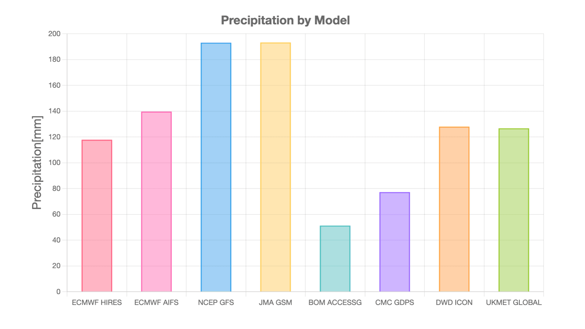
Base time of forecast models: 00:00 UTC, August 25, 2025
ECMWF: European Centre for Medium-Range Weather Forecasts NCEP: U.S. National Centers for Environmental Prediction JMA: Japan Meteorological Agency BOM: Australian Bureau of Meteorology CMC: Canadian Meteorological Centre DWD: Deutscher Wetterdienst UKMET: UK Met Office
At Weathernews, we strive to provide highly accurate forecasts by combining our proprietary prediction models with ensemble forecasting that integrates multiple global models. Through continuous verification of model performance, including AI-based approaches, we aim to deepen our understanding of each model's characteristics and deliver more reliable weather information to our users.
Footnotes
Share

March 6, 2026
Weathernews Launches Comprehensive BCP Service: Emergency Confirmation Powered by Weather Expertise

March 6, 2026
Taking on Japan's Most Widespread Health Challenge with Data and Passion: Why Weathernews Continues to Strengthen Its Pollen Information and the Commitment Behind It

February 27, 2026
When Will This Cherry Tree Blossom? Inside the Development of "Sakura AI Bloom Forecast" – Predicting Bloom Dates from a Single Photo