August 21, 2025
Typhoon No. 11 Strikes Taiwan – Evaluation of Heavy Rainfall and Forecast Accuracy

Weather Overview
Typhoon No. 11 (Podul) formed near the Northern Mariana Islands and steadily strengthened as it moved westward, ultimately making landfall in southern Taiwan on August 13. After landfall, the storm moved west at approximately 36 km/h, crossing southern Taiwan before entering the Taiwan Strait and continuing toward China that afternoon. The typhoon subsequently made a second landfall in South China, where it gradually weakened and was eventually downgraded to a tropical depression.
In Taiwan, maximum wind gusts of 53 m/s were recorded, while mountainous areas in the south received up to 660 mm of rainfall over a two-day period. Nine cities and counties, including Kaohsiung and Tainan, suspended school and business operations, and approximately 5,500 residents were evacuated. Taiwan's Central Emergency Operation Center reported the cancellation of 252 domestic flights and 129 international flights, causing severe disruption to transportation networks. As of 8:30 a.m. on August 14, authorities reported one person missing and 143 injured1.
Verification of Rainfall Forecast Accuracy
According to Taiwan's Central Weather Administration (CWA)2, the heaviest rainfall was recorded in Chunri Township, Pingtung County, where 644.5 mm fell during the 24-hour period from 00:00 UTC on August 13 to 00:00 UTC on August 14. Weathernews analyzed the rainfall forecasts from seven global meteorological models3 to evaluate their performance for this event.
As of 00:00 UTC on August 12, most models predicted over 200 mm of rainfall for the following 24 hours, correctly indicating the potential for heavy precipitation. The Canadian Meteorological Centre (CMC) model produced the highest forecast at 343 mm; however, even this prediction significantly underestimated the actual observed rainfall of 644.5 mm.
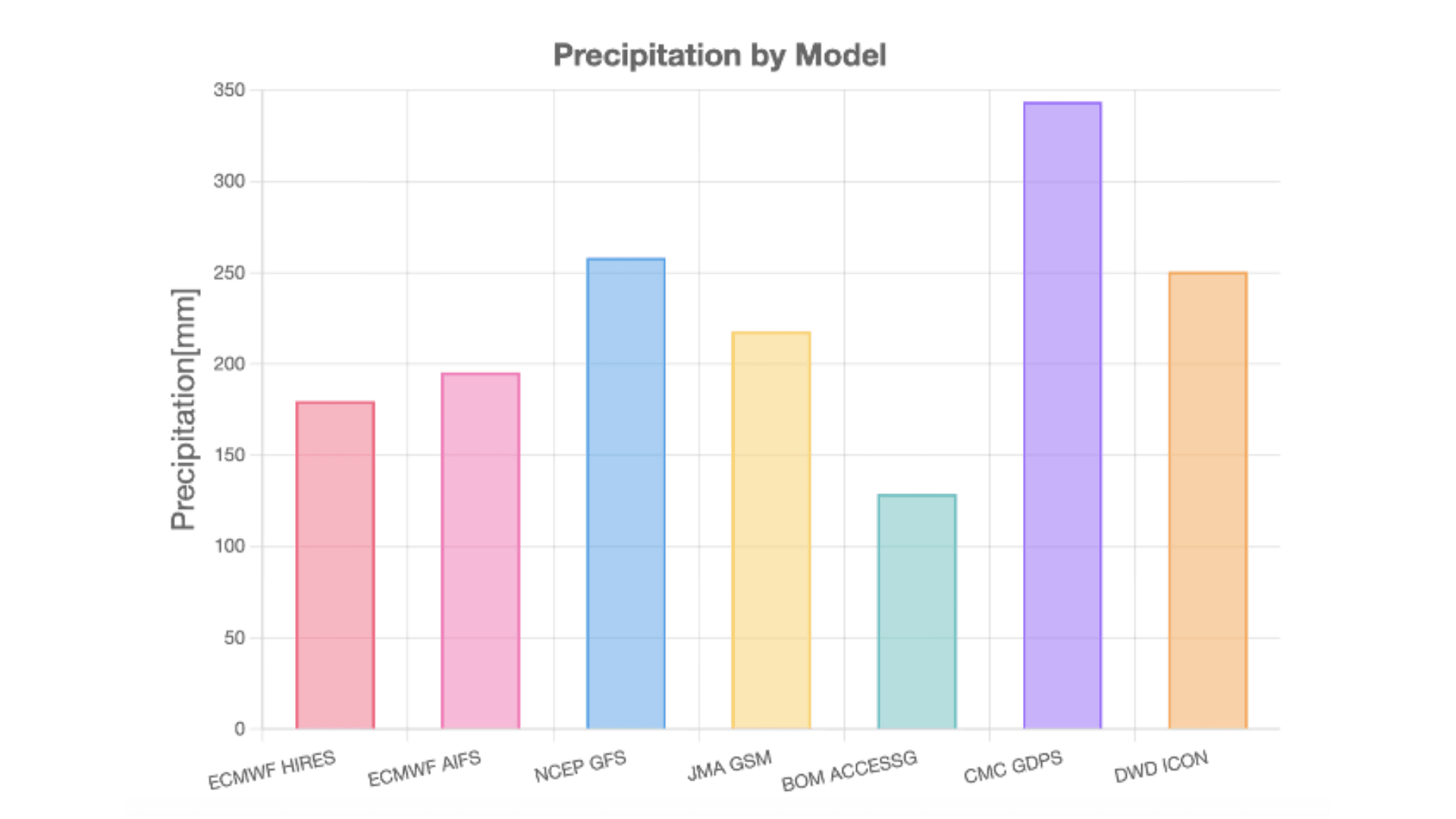
Base time: August 12, 00:00 (UTC) Location: Chunri Township, Pingtung County (Dahan Mountain Summit)
ECMWF: European Centre for Medium-Range Weather Forecasts NCEP: National Centers for Environmental Prediction (U.S.) JMA: Japan Meteorological Agency BOM: Australian Bureau of Meteorology CMC: Canadian Meteorological Centre DWD: Deutscher Wetterdienst (Germany)
Verification of Typhoon Track Forecast Accuracy
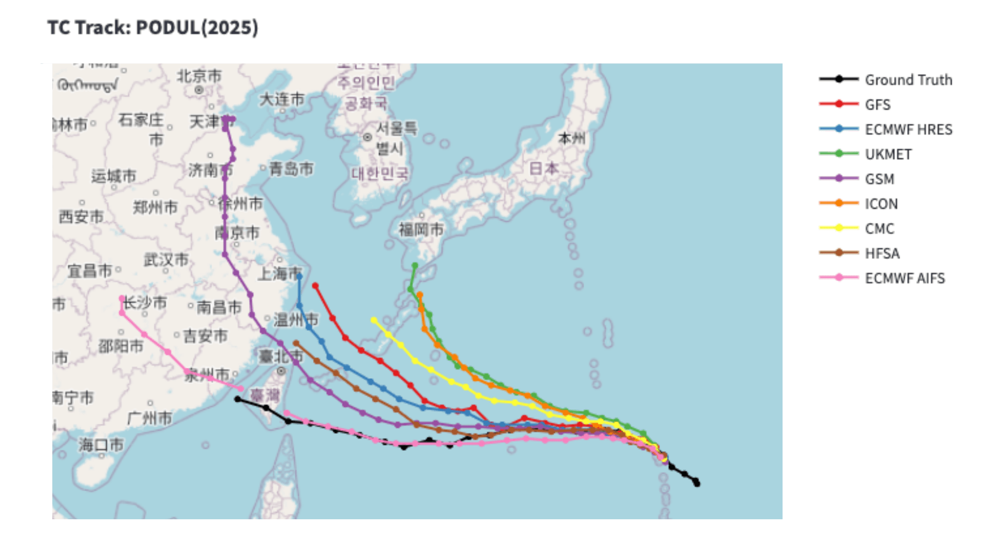
We also evaluated the track forecasts from eight different models for Typhoon No. 11. Figure 2 displays the forecast tracks from each model as of five days before the typhoon's landfall in Taiwan. Seven traditional physics-based models predicted the typhoon would pass north of Taiwan, while the ECMWF AI-based forecast system (AIFS) was the only model to correctly predict a direct hit on Taiwan.
GFS (NCEP): National Centers for Environmental Prediction (U.S.) ECMWF: European Centre for Medium-Range Weather Forecasts UKMET: UK Met Office GSM (JMA): Japan Meteorological Agency CMC: Canadian Meteorological Centre HFSA (NOAA): National Oceanic and Atmospheric Administration (U.S.) ICON (DWD): Deutscher Wetterdienst (Germany)
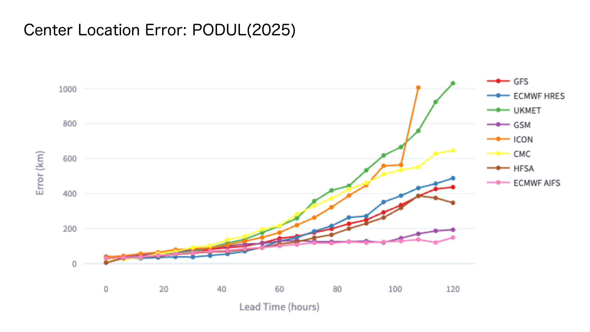
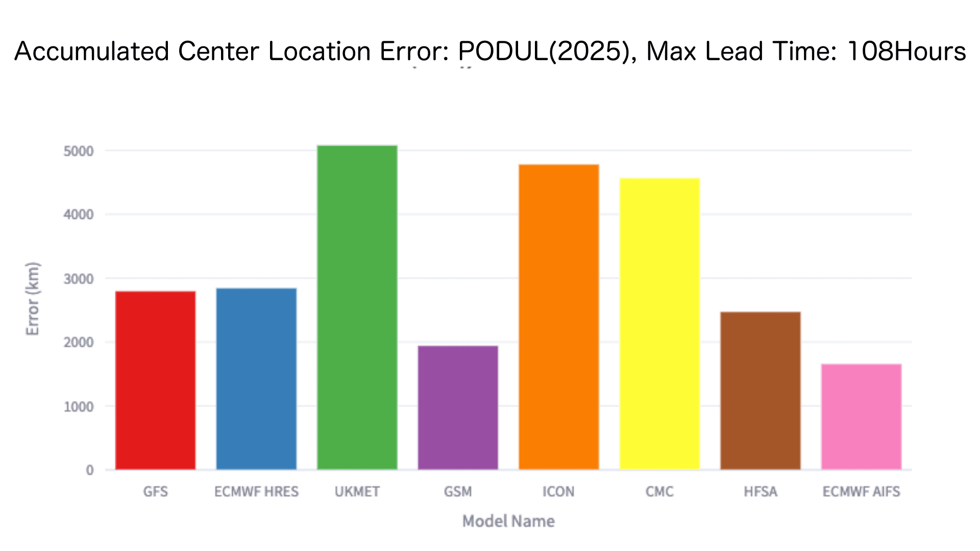
Figure 3 illustrates the relationship between forecast lead time and positional accuracy. The horizontal axis shows forecast lead time (hours in advance), while the vertical axis represents the positional error compared to actual observations. Lower values indicate higher accuracy. Notably, AIFS maintained a consistent error of approximately 100 km from 120 hours before landfall. When we analyzed cumulative forecast errors (Figure 4), the AI-based weather model demonstrated superior performance, achieving the smallest overall error and outperforming all physics-based models in track prediction accuracy.
GFS (NCEP): National Centers for Environmental Prediction (U.S.) ECMWF: European Centre for Medium-Range Weather Forecasts UKMET: UK Met Office GSM (JMA): Japan Meteorological Agency CMC: Canadian Meteorological Centre HFSA (NOAA): National Oceanic and Atmospheric Administration (U.S.) ICON (DWD): Deutscher Wetterdienst (Germany)
GFS (NCEP): National Centers for Environmental Prediction (U.S.) ECMWF: European Centre for Medium-Range Weather Forecasts UKMET: UK Met Office GSM (JMA): Japan Meteorological Agency CMC: Canadian Meteorological Centre HFSA (NOAA): National Oceanic and Atmospheric Administration (U.S.) ICON (DWD): Deutscher Wetterdienst (Germany)
At Weathernews, we are committed to delivering highly accurate forecasts by leveraging not only our proprietary forecast model but also ensemble forecasting techniques that integrate predictions from multiple global agencies. Through continuous verification studies like this one, including evaluation of cutting-edge AI-based models, we continuously refine our understanding of each model's strengths and limitations. This ongoing research enables us to provide increasingly precise and reliable weather information to our users.
Footnotes
- 1:https://tw.news.yahoo.com/楊柳快閃-台東狂風暴雨慘虐-140912075.html , https://tw.news.yahoo.com/颱風楊柳襲台釀災情-已1失蹤143傷-累計1052件災情|不斷更新-090040065.html , https://apnews.com/article/taiwan-typhoon-crop-damage-7ac077d3644bb29e9ba43467a0c77c3d ↩︎
- 2:Central Weather Administration of Taiwan - Rainfall Map, August 13 ↩︎
- 3:Global models: Meteorological models designed to predict large-scale phenomena such as low-pressure systems and typhoons on a global basis. ↩︎
Share

February 27, 2026
When Will This Cherry Tree Blossom? Inside the Development of "Sakura AI Bloom Forecast" – Predicting Bloom Dates from a Single Photo

February 19, 2026
Easing the Operational Load in the Maritime Industry: An AI Service Built on One Million Voyages

January 30, 2026
The Story Behind Specialized Indices That Show How Weather Impacts Daily Life—and How They've Evolved