August 8, 2025
Heavy Rainfall in Beijing, China on July 28-29, 2025 Enhancing Global Weather Model Validation
Overview
From July 28th to 29th, a front extending from a low-pressure system passed through the suburbs of Beijing, China. Furthermore, strong cold air moved in at high altitude, and moist air flowed in due to the approach of Typhoon No. 8, making the atmospheric conditions extremely unstable and resulting in heavy rainfall.
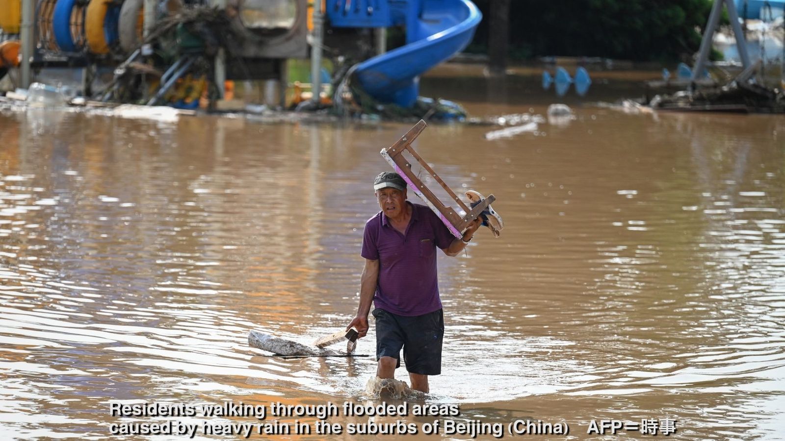
This intense precipitation led to severe flooding, which tragically resulted in 44 fatalities and forced 82,000 people to evacuate. More than 3,200 construction sites citywide have suspended operations.1
Actual Conditions
Observational data from Beijing shows that heavy rainfall exceeded 200mm between July 24th and 29th. To put this in perspective, Beijing's average July precipitation is 170.6mm, meaning the region received more than an entire month's worth of rain in just a few days. The rainfall occurred in two distinct phases: nearly 100mm fell from the 24th to 25th, followed by another intense period from the 28th to 29th when 24-hour totals reached 115mm. The flooding on the 28th was preceded by significant rainfall from an earlier frontal system, creating conditions that made Beijing particularly vulnerable to flooding and landslides. In response to these dangerous conditions, Beijing authorities issued rainstorm warnings and urged residents to exercise extreme caution.
Comparison of Model Predictions from Various Countries
Weathernews runs both proprietary forecasting models and meteorological prediction models from countries worldwide on a daily basis. We analyzed precipitation forecasts for the severe rainfall that devastated China during this event.
For the 24-hour period from July 28th to 29th, when Beijing's observation stations recorded peak precipitation, the Canadian Meteorological Centre (CMC) model showed the highest forecast at 47.0mm, based on its 12:00 UTC July 27th run. The European Centre for Medium-Range Weather Forecasts (ECMWF) model predicted 39.6mm in its 00:00 UTC July 27th run (12 hours earlier), outperforming other models at that lead time.
While all seven meteorological models we compared underestimated the actual rainfall amounts, they did indicate the potential for significant precipitation 12 to 24 hours ahead of the event.
To deliver highly accurate forecasts, Weathernews employs ensemble forecasting that combines our own' proprietary models with those from other institutions, continuously improving through rigorous accuracy assessments. We remain committed to enhancing our understanding of model characteristics through ongoing verification studies, ensuring we provide the most reliable meteorological information possible.
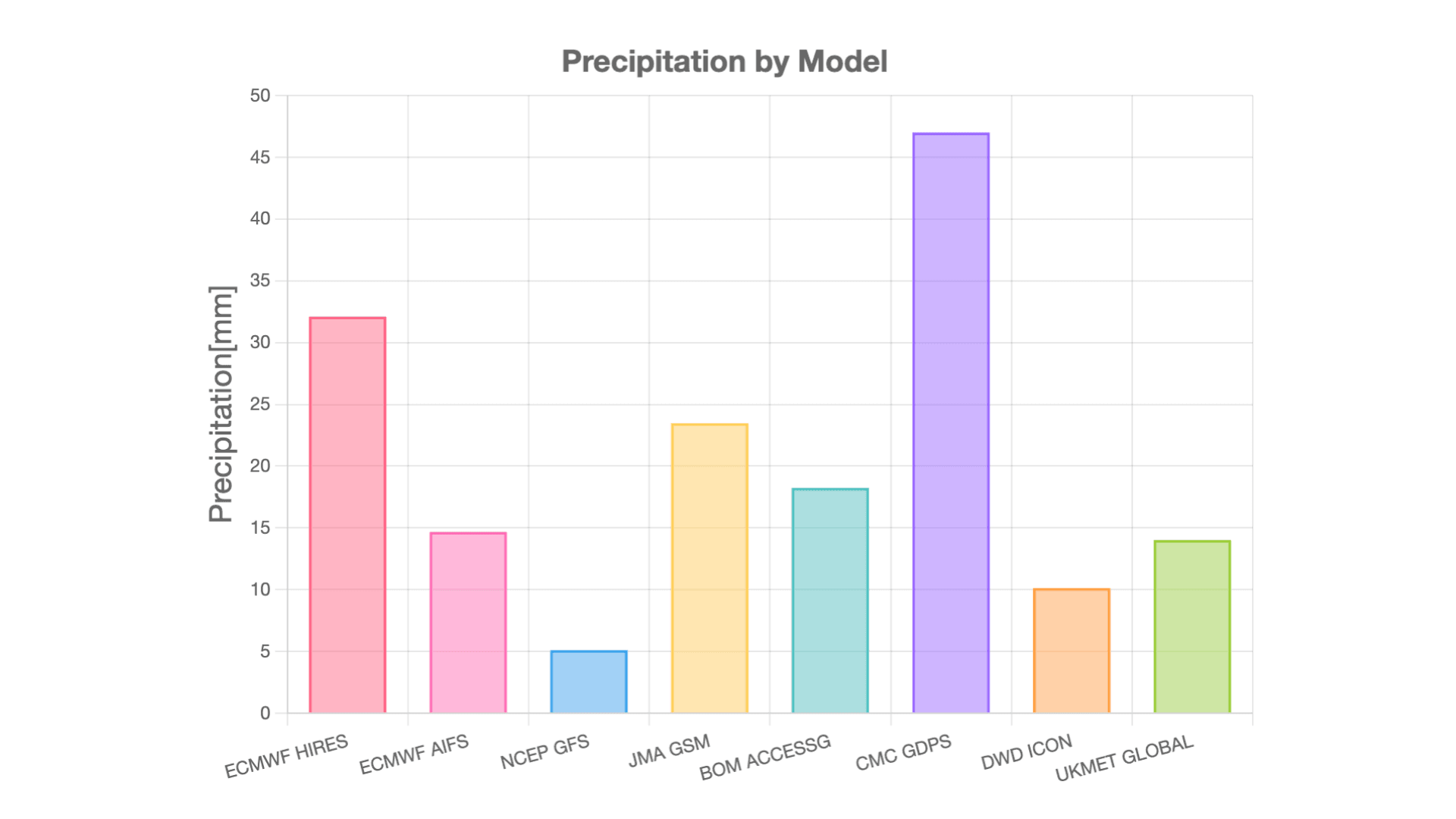
ECMWF: European Centre for Medium-Range Weather Forecasts NCEP: National Centers for Environmental Prediction (USA) JMA: Japan Meteorological Agency BOM: Bureau of Meteorology (Australia) CMC: Canadian Meteorological Centre DWD: Deutscher Wetterdienst (Germany) UKMET: UK Met Office
Footnotes
Share

March 16, 2026
Japan's Most Comprehensive Cherry Blossom Forecast: How Our Proprietary Bloom Prediction Model Leverages User-Generated Photos and High-Precision Data Across 1,400 Locations

March 13, 2026
How TV Stations Are Transforming Weather Coverage A New Content Solution Helping Broadcasters Navigate Weather and Disaster Reporting
March 6, 2026
Weathernews Launches Comprehensive BCP Service: Emergency Confirmation Powered by Weather Expertise