API (Application programming interface)
For more than 30 years, WNI has been providing reliable and accurate services to our customers through various service menus and software that we have developed. As an addition to our services, at 2016 we established a new API Platform that can deliver our high quality data to you. Through this data, you can enhance your service and operation, as well as create new solutions for your business.
API System Diagram
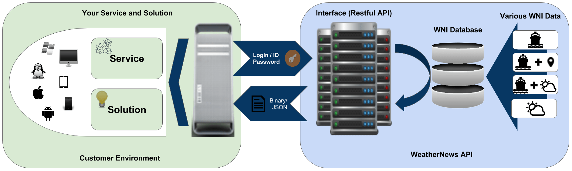
API System Flow Diagram

API System Flow Explanation
| Process | Explanation |
|---|---|
| Login Process | Login using a valid UID (Username) and PWD (Password) to create a TokenID. One TokenID is valid for 24 hours after creation (by default). If a user has logged in previously, then a TokenID expiration check will be done to determine the validity of the TokenID. If the TokenID is not valid, new TokenID will be generated; else the previous valid TokenID will be used to proceed in "Get Data Process". |
| Get Data Process | With a valid TokenID and Request Parameter, data will be accessed from the URL of the specific dataset. New data requests can be done as long as the TokenID is still valid; if the TokenID is no longer valid, there will be an error "403 - Forbidden". In case of expired TokenID, "Login Process" is necessary to continue requesting data. |
Dataset Summarize
| Data | Format | Update | Average Size | Forecast Duration | Time Pitch | Data Category |
|---|---|---|---|---|---|---|
| Binary | 00:00, 06:00, 12:00, 18:00 UTC | 256 K | 384 H | 6 H, 12 H | Weather | |
| Binary | 00:00, 06:00, 12:00, 18:00 UTC | 256 K | 384 H, 696 H, Actual | 3 H, 24 H | Weather | |
| Binary | 00:00, 06:00, 12:00, 18:00 UTC | 1.5 M | 96 H | 1 H | Weather | |
| Binary | 00:00, 06:00, 12:00, 18:00 UTC | 1.5 M | 96 H | 1 H | Weather | |
| JSON / XML | 00:00, 06:00, 12:00, 18:00 UTC | 20 K | 384 H, 696 H | 3 H, 6 H, 24 H | Weather | |
| KML | 00:30, 06:30, 12:30, 18:30 UTC | 1 M - 5 M | Actual, 384 H | 3 H, 6 H, 24 H | Weather | |
| JSON | 00:00, 06:00, 12:00, 18:00 UTC | 236 K | 168 H | 6 H | Weather | |
| JSON / XML | 02:00, 08:00, 14:00, 20:00 UTC | 44 K | Based on storm live time | - | Weather | |
| Binary | 10:00 UTC | 256 K | Actual | - | Ice Data | |
| Binary | 10:00 UTC | 256 K | 384 H | 24 H | Ice Data | |
| KML | 21:00 UTC | 3 M - 8 M | 384 H | 24 H | Ice Data | |
| JSON / XML | Vessel Reporting Time | 250 K - 7 M | Based on Track Length | - | Ship and Weather Data | |
| JSON / JSONP | Vessel Reporting Time | 4 K | - | - | Ship and Weather Data | |
| JSON / JSONP | - | 4 K | - | - | Ship and Weather Data | |
| JSON / XML | Vessel Reporting Time | 2 M - 7 M | Based on total reports | - | Ship and Weather Data | |
| JSON / JSONP | - | 4 K | - | - | TMAX Data | |
| JSON / JSONP | - | 4 K | - | - | TMAX Data | |
| JSON / JSONP | - | 250 K | - | - | TMAX Data | |
| JSON / JSONP | Irregular | 4 K / 560 K | - | - | TMAX Data | |
| JSON / JSONP | VAR Update Timing | 4 K | - | - | TMAX Data | |
| JSON / JSONP | Vessel Reporting Time | 4 K | - | - | TMAX Data | |
| JSON / CSV | End of Leg | 4 K | - | - | CIM Data |
Weather Data
| Data Name | Weather | |||
|---|---|---|---|---|
| Format | Binary | |||
| Region | Global | |||
| Element |
|
|||
| Update | 00:00, 06:00, 12:00, 18:00 UTC | |||
| Forecast | Duration | 384 H | ||
| Time Pitch | Element 1-14 | 6 H | ||
| Element 15 | 12 H | |||
| Detail of Region | Element 1-14 | Latitude | -90.000000 to 90.000000 by 1.000000 | |
| Longtitude | 0.000000 to 359.000000 by 1.000000 | |||
| Element 15 | t000 - t192 | Latitude | 89.844000 to -89.844000 by 0.204423 | |
| Longtitude | 0.000000 to 359.796000 by 0.204545 | |||
| t204 - t384 | Latitude | 89.522000 to -89.522000 by 0.623846 | ||
| Longtitude | 0.000000 to 359.375000 by 0.625000 | |||
| Resolution | Element 1-14 | 1.0 degree | ||
| Element 15 | t000 - t192 | 0.204 degree | ||
| t204 - t384 | 0.625 degree | |||
| Grid | Element 1-14 | 360 x 181 | ||
| Element 15 | t000 - t192 | 1760 x 880 | ||
| t204 - t384 | 576 x 288 | |||
| Matrix Reading Algorithm | 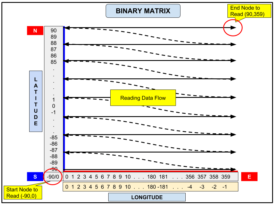 |
|||
| Average Size | 256 K | |||
Marine Weather Data
| Data Name | Marine Weather | ||
|---|---|---|---|
| Format | Binary | ||
| Region | Global | ||
| Element |
|
||
| Update |
|
00:00, 06:00, 12:00, 18:00 UTC | |
|
00:00 UTC | ||
|
13:00 UTC | ||
| Forecast |
|
Duration | 384 H |
| Time Pitch | 3 H | ||
|
Duration | 0 H | |
| Time Pitch | - | ||
|
Duration | 696 H | |
| Time Pitch | 24 H | ||
| Detail of Region |
|
Latitude | -90.000000 to 90.000000 by 1.000000 |
| Longtitude | 0.000000 to 359.000000 by 1.000000 | ||
|
Latitude | -89.500000 to 89.500000 by 1.000000 | |
| Longtitude | 0.500000 to 359.500000 by 1.000000 | ||
|
Latitude | -78.000000 to 80.000000 by 0.125000 | |
| Longtitude | 0.000000 to 359.875000 by 0.125000 | ||
| Resolution |
|
1.0 degree | |
|
0.125 degree | ||
| Grid |
|
360 x 181 | |
|
360 x 180 | ||
|
2880 x 1265 | ||
| Matrix Reading Algorithm | |
||
| Average Size | 256 K | ||
High Resolution Weather Data
| Data Name | High Resolution Weather | ||
|---|---|---|---|
| Format | Binary | ||
| Region | npac | North Pacific | |
| natl | North Atlantic | ||
| seaasia | South East Asia | ||
| Element |
|
||
| Update | 00:00, 06:00, 12:00, 18:00 UTC | ||
| Forecast | Duration | 96 H | |
| Time Pitch | 1 H | ||
| Detail of Region | npac | Latitude | 14.125000 to 66.000000 by 0.125000 |
| Longtitude | 101.000000 to 255.875000 by 0.125000 | ||
| natl | Latitude | 29.125000 to 61.000000 by 0.125000 | |
| Longtitude | 44.875000 to 270.000000 by 0.125000 | ||
| seaasia | Latitude | -15.875000 to 16.000000 by 0.125000 | |
| Longtitude | 85.000000 to 164.875000 by 0.125000 | ||
| Resolution | 0.125 degree | ||
| Grid | npac | 1240 x 416 | |
| natl | 1080 x 256 | ||
| seaasia | 640 x 256 | ||
| Matrix Reading Algorithm | |
||
| Average Size | 1.5 M | ||
High Resolution Marine Weather Data
| Data Name | High Resolution Marine Weather | ||
|---|---|---|---|
| Format | Binary | ||
| Region | npac | North Pacific | |
| natl | North Atlantic | ||
| seaasia | South East Asia | ||
| Element |
|
||
| Update | 00:00, 06:00, 12:00, 18:00 UTC | ||
| Forecast | Duration | 96 H | |
| Time Pitch | 1 H | ||
| Detail of Region | npac | Latitude | 15.000000 to 64.875000 by 0.125000 |
| Longtitude | 105.000000 to 249.875000 by 0.125000 | ||
| natl | Latitude | 30.000000 to 59.875000 by 0.125000 | |
| Longtitude | 275.000000 to 404.875000 by 0.125000 | ||
| seaasia | Latitude | -15.000000 to 14.875000 by 0.125000 | |
| Longtitude | 90.000000 to 159.875000 by 0.125000 | ||
| Resolution | 0.125 degree | ||
| Grid | npac | 1160 x 400 | |
| natl | 1040 x 240 | ||
| seaasia | 560 x 240 | ||
| Matrix Reading Algorithm | |
||
| Average Size | 1.5 M | ||
Weather on Track Data
| Data Name | Weather on Track | ||
|---|---|---|---|
| Format | JSON / XML | ||
| Region | Global | ||
| Element |
|
||
| Update | 00:00, 06:00, 12:00, 18:00 UTC | ||
| Forecast | Duration | 384 H, 696 H | |
| Time Pitch | Element 1-7 | 3 H | |
| Element 8-9 | 24 H | ||
| Element 10-11 | 6 H | ||
| Past Data | Duration | 5 Year | |
| Time Pitch | - | ||
| Detail of Region | Element 1-7 & 10-11 | Latitude | -90.000000 to 90.000000 by 1.000000 |
| Longtitude | 0.000000 to 359.000000 by 1.000000 | ||
| Element 8-9 | Latitude | 80.000000 to -78.000000 by 0.125000 | |
| Longtitude | 0.000000 to 359.875000 by 0.125000 | ||
| Resolution | Element 1-7, 10-11 | 1 degree | |
| Element 8-9 | 0.125 degree | ||
| Average Size | 20 K | ||
| 16 Direction/Degree Number | Direction Number | Compass Point | |
| 1 | NNE (North-northeast) | ||
| 2 | NE (Northeast) | ||
| 3 | ENE (East-northeast) | ||
| 4 | E (East) | ||
| 5 | ESE (East-southeast) | ||
| 6 | SE (Southeast) | ||
| 7 | SSE (South-southeast) | ||
| 8 | S (South) | ||
| 9 | SSW (South-southwest) | ||
| 10 | SW (Southwest) | ||
| 11 | WSW (West-southwest) | ||
| 12 | W (West) | ||
| 13 | WNW (West-northwest) | ||
| 14 | NW (Northwest) | ||
| 15 | NNW (North-northwest) | ||
| 16 | N (North) | ||
| Sample | |||
Weather KML
| Data Name | Weather KML | ||
|---|---|---|---|
| Format | KML | ||
| Region | Global | ||
| Element |
|
||
| Update | 00:30, 06:30, 12:30, 18:30 UTC | ||
| Forecast | Duration | Actual, 384 H | |
| Time Pitch | Element 1-5 | 3 H | |
| Element 6 | Actual | ||
| Element 7-14 | 6 H | ||
| Element 15 | 24 H | ||
| Contour Type | LineStyle | ||
| GRID Resolution | 1 degree | ||
| Contour Resolution | sigwh pwh swh pswh wsh |
1.0 meter | |
| sst tmp1000hpa tmp850hpa |
0.5 Celcius | ||
| rh850hpa rh700hpa |
5 % | ||
| ph1000hpa ph500hpa |
60 gpm | ||
| ssp | 4 hPa | ||
| intpcp | 2 kg/m^2 | ||
| icep | 0.25 Porpotions | ||
| Starting Point Value | Element 1-5 | 2.0 | |
| Element 6-15 | 0 | ||
| Average Size | 1 M - 5 M *Depends on contour and data resolution |
||
Ice Berg Data
| Data Name | Ice Berg | |
|---|---|---|
| Format | Binary | |
| Region | Global | |
| Update | 10:00 UTC | |
| Forecast | Duration | Actual |
| Time Pitch | - | |
| Detail of Region | Latitude | -90.000000 to 90.000000 by 1.000000 |
| Longtitude | 0.000000 to 359.000000 by 1.000000 | |
| Resolution | 1.0 degree | |
| Grid | 360 x 181 | |
| Matrix Reading Algorithm | |
|
| Average Size | 256 K | |
Ice Pack Data
| Data Name | Ice Pack | |
|---|---|---|
| Format | Binary | |
| Region | Global | |
| Update | 10:00 UTC | |
| Forecast | Duration | 384 H |
| Time Pitch | 24 H | |
| Detail of Region | Latitude | -89.500000 to 89.500000 by 1.000000 |
| Longtitude | 0.500000 to 359.499999 by 1.000000 | |
| Resolution | 1.0 degree | |
| Grid | 360 x 180 | |
| Matrix Reading Algorithm | |
|
| Average Size | 256 K | |
Ice KML
| Data Name | Ice KML | |||||||||||||||||||||||||||||||||||||||||
|---|---|---|---|---|---|---|---|---|---|---|---|---|---|---|---|---|---|---|---|---|---|---|---|---|---|---|---|---|---|---|---|---|---|---|---|---|---|---|---|---|---|---|
| Format | KML | |||||||||||||||||||||||||||||||||||||||||
| Region | Global | |||||||||||||||||||||||||||||||||||||||||
| Element |
|
|||||||||||||||||||||||||||||||||||||||||
| Update | 21:00 UTC | |||||||||||||||||||||||||||||||||||||||||
| Forecast | Duration | 384 H | ||||||||||||||||||||||||||||||||||||||||
| Time Pitch | 24 H | |||||||||||||||||||||||||||||||||||||||||
| Contour Type | Polygon | |||||||||||||||||||||||||||||||||||||||||
| Contour Resolution | iceconc | 0.1 ratio | ||||||||||||||||||||||||||||||||||||||||
| icethic | 0.25 meter | |||||||||||||||||||||||||||||||||||||||||
| icecomp | 5 kPa | |||||||||||||||||||||||||||||||||||||||||
| Starting Point Value | 0 | |||||||||||||||||||||||||||||||||||||||||
| Average Size | 3 M - 8 M *Depends on contour and data resolution |
|||||||||||||||||||||||||||||||||||||||||
| Countour colour legend | iceconc |
|
||||||||||||||||||||||||||||||||||||||||
| icethic |
|
|||||||||||||||||||||||||||||||||||||||||
| icecomp |
|
|||||||||||||||||||||||||||||||||||||||||
Front Data
| Data Name | Front | ||
|---|---|---|---|
| Format | JSON | ||
| Region | Global | ||
| Update | 00:00, 06:00, 12:00, 18:00 UTC | ||
| Forecast | Duration | 168 H | |
| Time Pitch | 6 H | ||
| Average Size | 236 K | ||
| Item Name | Full Name | Unit/Format | Values Type |
| FCASD | Forecast Date | datetime / (yyyy-mm-dd hh:mm:ss GMT) | string |
| obj_count | Target Object Count | - | int |
| TYPE | Object Type |
|
string |
| ARPRSS_CENTER | Air Pressure at Center | - | int |
| point_count | Polygon Point Count | - | int |
| LAT | Latitude | second | int |
| LON | Longitude | second | int |
| Sample | |||
Global Storm Data
| Data Name | Global Storm | ||
|---|---|---|---|
| Format | JSON / XML | ||
| Region | Global | ||
| Update | 02:00, 08:00, 14:00, 20:00 UTC | ||
| Forecast | Duration | Based on storm live time | |
| Time Pitch | - | ||
| Average Size | 44 K | ||
| Item Name | Full Name | Unit/Format | Values Type |
| tropCount | Total Tropical Strom in Data | - | Int |
| updateTime | Update Date of Data in UTC | datetime / (yyyy-mm-ddThh:mm:ss) | string |
| tropInfo | Tropical Storm Information | - | - |
| tropName | Tropical Name | [A-Z]-[A-Z] | string |
| tropType | Kind of Tropical Storm | TY, HUR, CYC | string |
| issueTime | Announcement time of the file | datetime / (yyyy-mm-ddThh:mm:ss) | string |
| analysisInfo | Analysis Information | - | - |
| forecastInfo | Forecast Information | - | - |
| trackInfo | Tropical Storm Track Information | - | - |
| class | State of Tropical Storm | TD, TS, STS, TY, XT, HUR | string |
| validTime | Target time | datetime / (yyyy-mm-ddThh:mm:ss) | string |
| point | Position (latitude, longtitude) | - | - |
| lat | Position Latitude | min | float |
| lon | Position Longtitude | min | float |
| windspeed_10min_max | Maximum wind speed | kts | float |
| pressure | Atmospheric pressure of Tropical Storm | hpa | float |
| gusts | Gust | kts | float |
| galeForceWindArea | - | - | - |
| stormForceWindArea | The quadrant strong wind range | - | - |
| radii_1 | The 1st quadrant strong wind range | distance [nm]: start orientation | string |
| radii_2 | The 2nd quadrant strong wind range | distance [nm] | string |
| radii_3 | The 3rd quadrant strong wind range | distance [nm] | string |
| radii_4 | The 4th quadrant strong wind range | distance [nm] | string |
| tropSpeed | Speed of Tropical Storm | kts | float |
| tropHeading | Heading/Direction of Tropical storm | direction 0-360 | float |
| Sample | |||
Voyage Track Data
| Data Name | Voyage Track | ||
|---|---|---|---|
| Format | JSON / XML | ||
| Region | Global | ||
| Update | Vessel Reporting Time | ||
| Forecast | Duration | Based on Track Length | |
| Time Pitch | - | ||
| Average Size | 250 K - 7 M (Based on Track Length) | ||
| Item Name | Full Name | Unit/Format | Values Type |
| shipInfo | Vessel information data | Hash Key | - |
| imoNum | Vessel IMO number | IMO number format | string |
| shipName | Vessel name | Maritime call sign format | string |
| callsign | Vessel Call Sign code | - | string |
| shipType | Vessel type (CONTAINER, PCTC, DRY BULK, TANKER) | - | string |
| voyageInfo | Voyage information data | Hash Key | - |
| departureInfo | Departure information data | Hash Key | - |
| arrivalInfo | Arrival information data | Hash Key | - |
| portName | Port name | - | string |
| portCode | Port code | - | string |
| reportedInfo | Master report information data | Hash Key | - |
| route | Vessel route data; Contains summary for each vessel route | Hash Key | - |
| routeInfo | Vessel route information data | Hash Key | - |
| routeType | Vessel route type (Actual, Recommended) | Hash Key | - |
| summary | Vessel route summary; Contains point track information | Hash Key | - |
| deadreckinigPointInfo | Dead reckoning point information data | Hash Key | - |
| point | Point track data | Hash Key (Array in Hash) | - |
| sourceId | Source of point data from master report | r1 is meaning "report 1st" | string |
| pointType | Type of point data | SOSP, NOON, EOSP, Reported | string |
| dateTime | Date and time of point data | Date (yyyy/mm/ddThh:mm:ss) | string |
| lat | latitude information | Minute | string |
| lon | longitude information | Minute | string |
| navTrack | Distance Measure : Rhumb line or Great Circle | GC (Great Circle), RL (Rhumb Line) | string |
| setRpm | Setting RPM in the point | rpm | string |
| averageRpm | Average RPM until the point | rpm | string |
| speed | Speed of vessel in the point | m/s | string |
| slip | Slip of vessel in the point | - | string |
| heading | Heading of vessel in the point | Decimal | string |
| setLoad | Loading condition of vessel in the point | - | string |
| fuel | High sulfure and Low sulfire fuel oil information of vessel in the point | Hash Key | - |
| diesel | Diesel fuel information of vessel in the point | Hash Key | - |
| gas | Gas fuel information of vessel in the point | Hash Key | - |
| ultraLowsulfur | Ultra low sulfur fuel oil information of vessel in the point | Hash Key | - |
| remainOnBoard | Remaining fuel of vessel from each fuel type | Hash Key | - |
| mainEngineConsumption | Fuel comsumption of vessel main engine | Hash Key | - |
| auxiliaryEngineConsumption | Fuel consumption of auxiliary engine | Hash Key | - |
| generatorConsumption | Fuel comsumption of generator | Hash Key | - |
| boilerConsumption | Fuel comsumption of boiler | Hash Key | - |
| otherConsupmtion | Another use/consumption of fuel | Hash Key | - |
| highSulfur | High sulfur oil information from each type | - | string |
| lowSulfur | Low sulfur oil information from each type | - | string |
| total | Combination between high sulfur and low sulfur | - | string |
| weather | Weather information data | Hash Key | - |
| significantWaveHeight | Significant wave height | Meter | string |
| primaryWaveHeight | Primary wave height | Meter | string |
| primaryWaveDirection | Primary wave direction (Comming From) | Decimal | string |
| primaryWavePeriod | Primary wave period | - | string |
| secondlyWaveHeight | Secondly wave height | Meter | string |
| secondlyWaveDirection | Secondly wave direction (Comming From) | Decimal | string |
| secondlyWavePeriod | Secondly wave period | - | string |
| swellWaveHeight | Swell wave height | Meter | string |
| swellWaveDirection | Swell wave direction (Comming From) | Decimal | string |
| swellWavePeriod | Swell wave period | - | string |
| windSeaWaveHeight | Wind sea wave height | Meter | string |
| windSeaWaveDirection | Wind sea wave direction (Comming From) | Decimal | string |
| windSeaWavePeriod | Wind sea wave period | - | string |
| currentU | Ocean current u-component | Vector | string |
| currentV | Ocean current v-component | Vector | string |
| windU | wind u-component | Vector | string |
| windV | wind v-component | Vector | string |
| currentFactor | Current Factor | Probability | string |
| Sample | Single voyage info structure | ||
| List voyage info structure | |||
Hire Bunker (GET) Data
| Data Name | Hire Bunker Cost Data | |||
|---|---|---|---|---|
| Format | JSON | |||
| Region | Global | |||
| Update | Vessel Reporting Time | |||
| Average Size | 4 K | |||
| Item Key Name | Item Code at JSON Output | Format | Sample Value | Unit |
| <IMO Number> | Vessel IMO number | Hash | 999999 | |
| LatestReceived | Latest received hire bunker cost data | Hash | ||
| bunker | Bunker data | Array | ||
| unit | Bunker item unit | String | USD/mt | |
| label | Bunker item sulfur concentrate labeling | String | FO over 1.0% | |
| type | Bunker item type | String | hsfo | |
| value | Bunker item value | String | 500 | |
| updateTime | Latest received hire bunker cost data date and time | String | 2020-06-04T07:38:58Z | UTC |
| hire | Hire data | Hash | ||
| unit | Hire data unit | String | USD/day | |
| value | Hire data value | String | 10000 | |
| VoyagePlanning | Hire bunker cost data applied on vessel’s voyage planning data | Hash | ||
| bunker | Bunker data | Array | ||
| unit | Bunker item unit | String | USD/mt | |
| label | Bunker item sulfur concentrate labeling | String | FO over 1.0% | |
| type | Bunker item type | String | hsfo | |
| value | Bunker item value | String | 500 | |
| updateTime | Latest update voyage planning data date and time | String | 2020-06-04T07:38:58Z | UTC |
| voyageInfo | Voyage planning information | Hash | ||
| arrivalInfo | Arrival information | Hash | ||
| portName | Arrival port name | String | URAGA SUIDO | |
| portCode | Arrival port code | String | URG | |
| point | Arrival position data | Hash | ||
| lon | Arrival longitude data | String | 8386.8 | Minutes |
| lat | Arrival latitude data | String | 2112.5 | Minutes |
| departureInfo | Departure information | Hash | ||
| portName | Departure port name | String | NEW WESTMINSTER | |
| portCode | Departure port code | String | NWM | |
| point | Departure position data | Hash | ||
| lon | Departure longitude data | String | -7374.6 | Minutes |
| lat | Departure latitude data | String | 2951.9 | Minutes |
| hire | Hire data | Hash | ||
| unit | Hire data unit | String | USD/day | |
| value | Hire data value | String | 10000 | |
| Sample | ||||
| Bunker Type at JSON | Sulfur Concentrate Labeling | |||
| hsfo | FO over 1.0% | |||
| lsfo | FO max 1.0% | |||
| vlsfo | FO max 0.5% | |||
| uls | FO max 0.1% | |||
| uls | GO over 0.5% | |||
| msgo | GO max 0.5% | |||
| lsgo | GO max 0.1% | |||
| hsdo | DO over 0.5% | |||
| msdo | DO max 0.5% | |||
| lsdo | DO max 0.1% | |||
Hire Bunker (PUT) Data
| Data Name | Hire Bunker Cost Data | |||||
|---|---|---|---|---|---|---|
| Format | JSON | |||||
| Region | Global | |||||
| Update | - | |||||
| Average Size | 4 K | |||||
| Item Code at JSON Output | Item Meaning | Value Format (Regular Expression) | Sample Value | Value Type | Mandatory | Default Value |
| <IMO Number> | Vessel IMO number | ^[0-9]+$ | 999999 | Hash | Yes | - |
| bunker | - | - | Array | Yes | - | |
| type | Bunker type | hsfo | String | Yes | - | |
| unit | Bunker cost unit | USD/mt | USD/mt | String | No | USD/mt |
| value | Bunker cost value | ^[0-9]+$ | 500 | Integer | No | N/A |
| hire | - | - | Hash | Yes | - | |
| unit | Hire cost unit | USD/day | USD/day | String | No | USD/day |
| value | Hire cost value | ^[0-9]+$ | 20000 | Integer | No | N/A |
| Sample | ||||||
| Bunker Type at JSON | Sulfur Concentrate Labeling | |||||
| hsfo | FO over 1.0% | |||||
| lsfo | FO max 1.0% | |||||
| vlsfo | FO max 0.5% | |||||
| uls | FO max 0.1% | |||||
| uls | GO over 0.5% | |||||
| msgo | GO max 0.5% | |||||
| lsgo | GO max 0.1% | |||||
| hsdo | DO over 0.5% | |||||
| msdo | DO max 0.5% | |||||
| lsdo | DO max 0.1% | |||||
QRT
| Data Name | QRT (Quick Report Template) Data / Vessel Report Data | ||
|---|---|---|---|
| Format | JSON / XML | ||
| Region | Global | ||
| Update | Vessel Reporting Time | ||
| Forecast | Duration | - | |
| Time Pitch | - | ||
| Average Size | 2 M - 7 M (Based on Total Report) | ||
| Sample | JSON | ||
| XML | |||
Sea Margin Data
| Data Name | Sea Margin | ||||
|---|---|---|---|---|---|
| Format | JSON / JSONP | ||||
| Region | Global | ||||
| Update | - | ||||
| Forecast | Duration | - | |||
| Time Pitch | - | ||||
| Average Size | 4 K | ||||
| No Data Value | -9999999 | ||||
| Route Type | Item Category | Item Name | Description | Unit/Format | Values Type |
| Shortest without WF, CF | - | shortest_without_wfcf | Geographically shortest route without weather factor and current factor | - | - |
| Shortest | - | shortest | Geographically shortest route with weather factor and current factor | - | - |
| Frequently Navigated | - | frequently_navigated | Frequently navigated route with weather factor and current factor | - | |
| Shortest without WF, CF | - | distance | Distance of route | nm (nautical miles) | Float |
| Shortest without WF, CF | days | days | Estimated passage days | Day | Float |
| Shortest without WF, CF | days | difference | No data in this column. Days of "shortest_without_wfcf" is used as basis of comparison | Day | Float |
| Shortest without WF, CF | days | % | No data in this column. Days of "shortest_without_wfcf" is used as basis of comparison | % | Float |
| Shortest without WF, CF | - | Fuel | Estimated fuel oil consumption | MT | Float |
| Shortest without WF, CF | speed | avg | No data in this column. | Knot | Float |
| Shortest without WF, CF | speed | wf | No data in this column. | Knot | Float |
| Shortest without WF, CF | speed | cf | No data in this column. | Knot | Float |
| Shortest | - | distance | Distance of route | nm (nautical miles) | Float |
| Shortest | days | days | Estimated passage days | Day | Float |
| Shortest | days | difference | Difference of passage days between "Shortest" and "Shortest without WF, CF" | Day | Float |
| Shortest | days | % | Percentage of difference of passage days | % | Float |
| Shortest | - | Fuel | Estimated fuel oil consumption | MT | Float |
| Shortest | speed | avg | Average speed | Knot | Float |
| Shortest | speed | wf | Weather factor | Knot | Float |
| Shortest | speed | cf | Current factor | Knot | Float |
| Frequently Navigated | - | distance | Distance of route | nm (nautical miles) | Float |
| Frequently Navigated | days | days | Estimated passage days | Day | Float |
| Frequently Navigated | days | difference | Difference of passage days between "Frequently Navigated" and "Shortest without WF, CF" | Day | Float |
| Frequently Navigated | days | % | Percentage of difference passage days | % | Float |
| Frequently Navigated | - | Fuel | Estimated fuel oil consumption | MT | Float |
| Frequently Navigated | speed | avg | Average speed | Knot | Float |
| Frequently Navigated | speed | wf | Weather factor | Knot | Float |
| Frequently Navigated | speed | cf | Current factor | Knot | Float |
| Sample | |||||
Sea Margin(Area to Area) Data
| Data Name | Sea Margin(Area to Area) | ||||
|---|---|---|---|---|---|
| Format | JSON / JSONP | ||||
| Region | Global | ||||
| Update | - | ||||
| Forecast | Duration | - | |||
| Time Pitch | - | ||||
| Average Size | 4 K | ||||
| No Data Value | -9999999 | ||||
| Route Type | Item Category | Item Name | Description | Unit/Format | Values Type |
| - | - | ship_type | Ship type | - | String |
| - | - | ship_size | Ship size | - | String |
| - | - | loading | Loading condition of the ship | String | |
| Departure Area | - | code | Departure area name | Area Code | String |
| Departure Area | - | name | Departure area name | - | String |
| Arrival Area | - | code | Arrival area name | Area Code | String |
| Arrival Area | - | name | Arrival area name | - | String |
| Calm Sea Speed | speed | calm_sea_speed | Speed of calm sea as a base for calculation | Knot | Float |
| Annual Sea Margin | days | annual_sea_margin | Annual percentage of passage days difference | % | Float |
| Total Voyages | - | all | Total voyages within the analysis | - | String |
| Total Voyages | - | winter | Winter(Dec, Jan, Feb) voyages within the analysis | - | String |
| Total Voyages | - | spring | Spring(Mar, Apr, May) voyages within the analysis | - | String |
| Total Voyages | - | summer | Summer(Jun, Jul, Aug) voyages within the analysis | - | String |
| Total Voyages | - | autumn | Autumn(Sep, Oct, Nov) voyages within the analysis | - | String |
| SimulationInfo Monthly | days | sea_margin | Percentage of passage days difference | % | Float |
| SimulationInfo Monthly | speed | avg_speed | Average speed | Knot | Float |
| SimulationInfo Monthly | speed | wf | Weather factor | Knot | Float |
| SimulationInfo Monthly | speed | cf | Current factor | Knot | Float |
| Sample | |||||
Sea Margin(Area to Area) Area Table
| No. | Area Code | Area Name |
|---|---|---|
| 1 | 1 | JAPAN |
| 2 | 2 | NORTH CHINA |
| 3 | 3 | SINGAPORE/INDOCHINA |
| 4 | 4 | SOUTH EAST ASIA |
| 5 | 5 | PAPUA NEW GUINEA |
| 6 | 6 | NORTH WEST AUSTRALIA |
| 7 | 7 | SOUTH WEST AUSTRALIA |
| 8 | 8 | SOUTH EAST AUSTRALIA |
| 9 | 9 | NORTH EAST AUSTRALIA |
| 10 | 10 | NEW ZEALAND |
| 11 | 11 | HAWAII |
| 12 | 12 | ALASKA |
| 13 | 13 | ALEUTIAN ISLANDS |
| 14 | 14 | PACIFIC NORTHWEST |
| 15 | 15 | CALIFORNIA |
| 16 | 16 | CENTRAL AMERICA |
| 17 | 17 | COLUMBIA/ECUADOR/PERU |
| 18 | 18 | CHILE |
| 19 | 19 | PANAMA |
| 20 | 20 | GREAT LAKES/CANADA |
| 21 | 21 | US NORTH EAST COAST |
| 22 | 22 | US SOUTH EAST COAST |
| 23 | 23 | US GULF |
| 24 | 24 | CARIBBEAN |
| 25 | 25 | BRAZIL |
| 26 | 26 | NE OF SOUTH AMERICA |
| 27 | 27 | URUGUAY/ARGENTINA |
| 28 | 28 | CAPE HORN |
| 29 | 29 | BALTIC SEA |
| 30 | 30 | NORTH SEA |
| 31 | 31 | NORWEGIAN SEA |
| 32 | 32 | WEST UK |
| 33 | 33 | SPAIN/PORTUGAL |
| 34 | 34 | GIBRALTAR |
| 35 | 35 | MEDITERANIA |
| 36 | 36 | CANARY ISLANDS |
| 37 | 37 | CENTRAL AFRICA |
| 38 | 38 | ANGOLA/S.W.AFRICA |
| 39 | 39 | CAPE OF GOOD HOPE |
| 40 | 40 | EAST AFRICA |
| 41 | 41 | RED SEA |
| 42 | 42 | WEST INDIA/PAKISTAN |
| 43 | 43 | EAST INDIA |
| 44 | 44 | PERSIAN GULF |
| 45 | 45 | MOZAMBIQUE/MALAGASY |
Tonnage Allocation Planner Data
| Data Name | Tonnage Allocation Planner | ||||
|---|---|---|---|---|---|
| Format | JSON / JSONP | ||||
| Region | Global | ||||
| Update | - | ||||
| Forecast | Duration | - | |||
| Time Pitch | - | ||||
| Average Size | 250 K | ||||
| No Data Value | -9999999 | ||||
| Route Type | Item -> Sub Item Category | Item Name | Description | Unit/Format | Values Type |
| Shortest | - | shortest | Shortest distance route | - | - |
| WNI Recomm 1 | - | wni_recomm1 | Weathernews recommended route | - | - |
| Shortest / WNI Recomm 1 | ports | departure_port_name | Departure port name | - | String |
| Shortest / WNI Recomm 1 | ports | departure_port_code | Weathernews departure port code | - | String |
| Shortest / WNI Recomm 1 | ports | arrival_port_name | Arrival port name | - | String |
| Shortest / WNI Recomm 1 | ports | arrival_port_code | Weathernews arrival port code | - | String |
| Shortest / WNI Recomm 1 | ports | vessel_condition | Vessel loading condition |
|
String |
| Shortest / WNI Recomm 1 | ports | etd_utc | Estimated time of departure (UTC time) | UTC | String / (mm/dd hh:mm) |
| Shortest / WNI Recomm 1 | ports | eta_utc | Estimated time of arrival (UTC time) | UTC | String / (mm/dd hh:mm) |
| Shortest / WNI Recomm 1 | ports | etd_lt | Estimated time of departure (Local time) | LT | String / (mm/dd hh:mm) |
| Shortest / WNI Recomm 1 | ports | eta_lt | Estimated time of arrival (Local time) | LT | String / (mm/dd hh:mm) |
| Shortest / WNI Recomm 1 | ports -> distance | outside_eca | Distance outside ECA (Emission Control Area) | nm (nautical miles) | Float |
| Shortest / WNI Recomm 1 | ports -> distance | inside_eca | Distance inside ECA (Emission Control Area) | nm (nautical miles) | Float |
| Shortest / WNI Recomm 1 | ports -> days | outside_eca | Estimated days outside ECA (Emission Control Area) | Day | Float |
| Shortest / WNI Recomm 1 | ports -> days | inside_eca | Estimated days inside ECA (Emission Control Area) | Day | Float |
| Shortest / WNI Recomm 1 | ports -> days | dep_port_staying | Port stay days | Day | Float |
| Shortest / WNI Recomm 1 | ports -> fuel | ifo | Estimated fuel oil consumption | MT | Float |
| Shortest / WNI Recomm 1 | ports -> fuel | eca | Estimated fuel oil consumption inside ECA (Emission Control Area) | MT | Float |
| Shortest / WNI Recomm 1 | ports -> speed | average | Average speed | Knot | Float |
| Shortest / WNI Recomm 1 | ports -> speed | wf | Weather factor | Knot | Float |
| Shortest / WNI Recomm 1 | ports -> speed | cf | Current factor | Knot | Float |
| Shortest / WNI Recomm 1 | sub_total -> distance | outside_eca | Subtotal of distance outside ECA (Emission Control Area) | nm (nautical miles) | Float |
| Shortest / WNI Recomm 1 | sub_total -> distance | inside_eca | Subtotal of distance inside ECA (Emission Control Area) | nm (nautical miles) | Float |
| Shortest / WNI Recomm 1 | sub_total -> days | inside_eca | Subtotal of estimated days inside ECA (Emission Control Area) | Day | Float |
| Shortest / WNI Recomm 1 | sub_total -> days | outside_eca | Subtotal of estimated days outside ECA (Emission Control Area) | Day | Float |
| Shortest / WNI Recomm 1 | sub_total -> days | dep_port_staying | Subotal of port stay days | Day | Float |
| Shortest / WNI Recomm 1 | sub_total -> fuel | ifo | Subtotal of estimated fuel oil consumption | MT | Float |
| Shortest / WNI Recomm 1 | sub_total -> fuel | eca | Subtotal of estimated fuel oil consumption inside ECA (Emission Control Area) | MT | Float |
| Shortest / WNI Recomm 1 | total | distance | Total distance inside and outside ECA (Emission Control Area) | nm (nautical miles) | Float |
| Shortest / WNI Recomm 1 | total | days | Total of estimated passage days inside and outside ECA (Emission Control Area), and total port stay days | Day | Float |
| Shortest / WNI Recomm 1 | total -> fuel | ifo | Total of estimated fuel oil consumption | MT | Float |
| Shortest / WNI Recomm 1 | total -> fuel | eca | Total of estimated fuel oil consumption inside ECA (Emission Control Area) | MT | Float |
| Shortest / WNI Recomm 1 | waypoint -> position | lat | Latitude of route waypoint | Minute | Float |
| Shortest / WNI Recomm 1 | waypoint -> position | lon | Longitude of route waypoint | Minute | Float |
| Shortest / WNI Recomm 1 | waypoint -> position | datetime | Date and time of route waypoint | Minute | String / (mm/dd hh:mm) |
| Sample | |||||
TMAX Port Data
| Data Name | TMAX Port | ||||
|---|---|---|---|---|---|
| Format | JSON / JSONP | ||||
| Region | Global | ||||
| Update | Irregular | ||||
| Forecast | Duration | - | |||
| Time Pitch | - | ||||
| Average Size | 4 K / 560 K | ||||
| No Data Value | -9999999 | ||||
| Item Name | Description | Unit/Format | Values Type | ||
| port_code | Weathrenews port code | - | String | ||
| port_name | Port name | - | String | ||
| tz_name | Time zone area name | - | String | ||
| country_name | Port country name | - | String | ||
| lat | Port latitude position | Minute | Float | ||
| lon | Port longitude position | Minute | Float | ||
| Sample | |||||
Post Voyage CP Warranty Data
| Data Name | Post Voyage CP Warranty | ||
|---|---|---|---|
| Format | JSON / JSONP | ||
| Region | Global | ||
| Update | VAR Update Timing | ||
| Average Size | 4 K | ||
| No Data Value | Empty string ("") | ||
| Item Code at JSON Output | Item Meaning | Unit/Format | Value Type |
| ship_name | Ship name | - | String |
| imo_num | IMO number | - | String |
| voy_num | Voyage number | - | String |
| loading_condition | Loading condition | - | String |
| eco_speed | Economical speed | - | String |
| seg | Segment | - | String |
| dep_port | Departure port | - | String |
| atd | Arrival time departure | - | String |
| arr_port | Arrival port | - | String |
| ata | Actual time arrival | - | String |
| [loss_saving]time | Loss saving time | hours | String |
| [loss_saving]fo | Loss saving fuel oil | MT/LT | String |
| [loss_saving]do | Loss saving diesel oil | MT/LT | String |
| [loss_saving]fuel_unit | Loss saving fuel unit | MT/LT | String |
| is_warranted | Being warranted flag | - | String |
| [comment]red | Red comment | - | String |
| [comment]yellow | Yellow comment | - | String |
| [comment]blue | Blue comment | - | String |
| [outside_eca]goodwx_dist | Good weather distance at outside ECA (emission control area) | NM | String |
| [outside_eca]goodwx_time | Good weather time at outside ECA (emission control area) | hours | String |
| [outside_eca]goodwx_avg_speed | Good weather average speed at outside ECA (emission control area) | knots | String |
| [outside_eca]goodwx_current | Good weather current at outside ECA (emission control area) | knots | String |
| [outside_eca]goodwx_perf_speed | Good weather performance speed at outside ECA (emission control area) | knots | String |
| [outside_eca]goodwx_total_fo | Good weather total fuel oil at outside ECA (emission control area) | MT | String |
| [outside_eca]goodwx_total_do | Good weather total diesel oil at outside ECA (emission control area) | MT | String |
| [outside_eca]goodwx_daily_fo | Good weather daily fuel oil at outside ECA (emission control area) | MT/day | String |
| [outside_eca]goodwx_daily_do | Good weather daily diesel oil at outside ECA (emission control area) | MT/day | String |
| [outside_eca]entire_dist | Entire distance at outside ECA (emission control area) | NM | String |
| [outside_eca]entire_time | Entire time at outside ECA (emission control area) | hours | String |
| [outside_eca]entire_avg_speed | Entire average speed at outside ECA (emission control area) | knots | String |
| [outside_eca]entire_current | Entire current at outside ECA (emission control area) | knots | String |
| [outside_eca]entire_perf_speed | Entire performance speed at outside ECA (emission control area) | knots | String |
| [outside_eca]entire_total_fo | Entire total fuel oil at outside ECA (emission control area) | MT | String |
| [outside_eca]entire_total_do | Entire total diesel oil at outside ECA (emission control area) | MT | String |
| [outside_eca]entire_daily_fo | Entire daily fuel oil at outside ECA (emission control area) | MT/day | String |
| [outside_eca]entire_daily_do | Entire daily diesel oil at outside ECA (emission control area) | MT/day | String |
| [inside_eca]goodwx_dist | Good weather distance at inside ECA (emission control area) | NM | String |
| [inside_eca]goodwx_time | Good weather time at inside ECA (emission control area) | hours | String |
| [inside_eca]goodwx_avg_speed | Good weather average speed at inside ECA (emission control area) | knots | String |
| [inside_eca]goodwx_current | Good weather current at inside ECA (emission control area) | knots | String |
| [inside_eca]goodwx_perf_speed | Good weather performance speed at inside ECA (emission control area) | knots | String |
| [inside_eca]goodwx_total_fo | Good weather total fuel oil at inside ECA (emission control area) | MT | String |
| [inside_eca]goodwx_total_do | Good weather total diesel oil at inside ECA (emission control area) | MT | String |
| [inside_eca]goodwx_daily_fo | Good weather daily fuel oil at inside ECA (emission control area) | MT/day | String |
| [inside_eca]goodwx_daily_do | Good weather daily diesel oil at inside ECA (emission control area) | MT/day | String |
| [inside_eca]entire_dist | Entire distance at inside ECA (emission control area) | NM | String |
| [inside_eca]entire_time | Entire time at inside ECA (emission control area) | hours | String |
| [inside_eca]entire_avg_speed | Entire average speed at inside ECA (emission control area) | knots | String |
| [inside_eca]entire_current | Entire current at inside ECA (emission control area) | knots | String |
| [inside_eca]entire_perf_speed | Entire performance speed at inside ECA (emission control area) | knots | String |
| [inside_eca]entire_total_fo | Entire total fuel oil at inside ECA (emission control area) | MT | String |
| [inside_eca]entire_total_do | Entire total diesel oil at inside ECA (emission control area) | MT | String |
| [inside_eca]entire_daily_fo | Entire daily fuel oil at inside ECA (emission control area) | MT/day | String |
| [inside_eca]entire_daily_do | Entire daily diesel oil at inside ECA (emission control area) | MT/day | String |
| [goodwx_definition]goodwx_wind | good weather definition of wind | knots | String |
| [goodwx_definition]goodwx_bf | good weather definition of wind beaufort | beaufort | String |
| [goodwx_definition]goodwx_windspeed | good weather definition of wind speed | knots | String |
| [goodwx_definition]goodwx_dss | good weather definition of DSS scale | - | String |
| [goodwx_definition]goodwx_sigwave | good weather definition of significant wave | meter | String |
| [goodwx_definition]goodwx_windsea | good weather definition of windsea | meter | String |
| [goodwx_definition]gooodwx_swell | good weather definition of swell | meter | String |
| [goodwx_definition]goodwx_current | good weather definition of current | knots | String |
| [warranted]speed | Warranted speed | knots | String |
| [warranted]fo | Warranted fuel oil | MT | String |
| [warranted]do | Warranted diesel oil | MT | String |
| [allowance]speed | Allowance speed | knots | String |
| [allowance]fo | Allowance fuel oil | MT | String |
| [allowance]do | Allowance diesel oil | MT | String |
| [allowance]speed_unit | Allowance speed_unit | knots / % | String |
| [allowance]fuel_unit | Allowance fuel unit | % / tons | String |
| rpm | Machine RPM | - | String |
| slip | Slip | % | String |
| co2_fo | Carbon dioxide that is produced from fuel oil | MT | String |
| co2_do | Carbon dioxide that is produced from diesel oil | MT | String |
| id | Identity Flag | - | String |
| Sample | |||
EnRoute CP Warranty Data
| Data Name | EnRoute CP Warranty | |||
|---|---|---|---|---|
| Format | JSON / JSONP | |||
| Region | Global | |||
| Update | Vessel Reporting Time | |||
| Average Size | 4 K | |||
| No Data Value | Empty string ("") | |||
| Item Code at JSON Output | Item Meaning | Unit/Format | Sample Value | Value Type |
| ship_name | Ship name | - | Ship A | String |
| imo_num | IMO number | - | 1010101 | String |
| voy_num | Voyage number | - | 123A | String |
| loading_condition | Loading condition | - | L | String |
| cp_warranty | CP warranty data | Hash | String | |
| [cp_warranty]analyzed_time | Analysis creation time | <month>-dd/yyyy hh:mm UTC Month format: |
Feb-24/2020 04:06 UTC | String |
| [cp_warranty]def_goodwx | Good weather definition | - | BF 4, Sig. Wave 1.25m (DSS3), No adverse Current | String |
| [cp_warranty]allwx_avg_speed | All weather average speed | knots | 11.91 | String |
| [cp_warranty]allwx_perf_speed | All weather performance speed | knots | 12.23 | String |
| [cp_warranty]allwx_distance | All weather distance | NM | 2850 | String |
| [cp_warranty]allwx_time | All weather time | hour | 239.2 | String |
| [cp_warranty]allwx_cf | All weather current factor | knots | -0.22 | String |
| [cp_warranty]allwx_daily_fo | All weather daily fuel oil | MT | 18.99 | String |
| [cp_warranty]allwx_daily_dogo | All weather daily diesel /gas oil | MT | 0.1 | String |
| [cp_warranty]allwx_total_fo | All weather total fuel oil | MT | 189.22 | String |
| [cp_warranty]allwx_total_dogo | All weather total diesel /gas oil | MT | 1 | String |
| [cp_warranty]goodwx_avg_speed | Good weather average speed | knots | 12.46 | String |
| [cp_warranty]goodwx_perf_speed | Good weather performance speed | knots | 12.15 | String |
| [cp_warranty]goodwx_distance | Good weather distance | NM | 617 | String |
| [cp_warranty]goodwx_time | Good weather time | hour | 49.5 | String |
| [cp_warranty]goodwx_sigwave | Good weather definition of significant wave height | meter | 1.25 | String |
| [cp_warranty]goodwx_cf | Good weather current factor | knots | 0.31 | String |
| [cp_warranty]goodwx_bf | Good weather definition of wind beaufort | beaufort | 4 | String |
| [cp_warranty]goodwx_current | Good weather definition of ocean current | - | No adverse Current | String |
| [cp_warranty]goodwx_daily_fo | Good weather daily fuel oil | MT | 18.98 | String |
| [cp_warranty]goodwx_daily_dogo | Good weather daily diesel/gas oil | MT | 0.1 | String |
| [cp_warranty]goodwx_total_fo | Good weather total fuel oil | MT | 39.15 | String |
| [cp_warranty]goodwx_total_dogo | Good weather total diesel/gas oil | MT | 0.2 | String |
| [cp_warranty]cp_speed | CP warranty speed | knots | 11.5 | String |
| [cp_warranty]cp_fo | CP warranty fuel oil | MT | 20.5 | String |
| [cp_warranty]cp_dogo | CP warranty diesel/gas oil | MT | 0.1 | String |
| [cp_warranty]cp_fuel_unit | CP warranty fuel unit | - | MT | String |
| [cp_warranty]allow_speed | Allowance speed | knots | 0.5 | String |
| [cp_warranty]allow_speed_unit | Allowance speed unit | - | kts | String |
| [cp_warranty]allow_fo | Allowance fuel oil | % | 5 | String |
| [cp_warranty]allow_dogo | Allowance diesel/gas oil | % | 5 | String |
| [cp_warranty]allow_fuel_unit | Allowance fuel unit | - | % | String |
| [cp_warranty]saving_time | Loss or saving time value | Unit: Hours Value mean: |
1.3 | String |
| [cp_warranty]saving_time_unit | Loss or saving time unit | - | hrs | String |
| [cp_warranty]saving_fo | Fuel oil over/under-consumption value | Unit: MT Value mean: |
-24.78 | String |
| [cp_warranty]saving_fuel_unit | Fuel oil over/under-consumption unit | - | MT | String |
| [cp_warranty]saving_dogo | DO/GO over/under-consumption value | Unit: MT Value mean: |
-0.13 | String |
| [cp_warranty]damage_info_speed | Time loss or saving information | Value options: |
time lost | String |
| [cp_warranty]damage_info_fo | Fuel oil over/under-consumption information | Value options: |
saving | String |
| [cp_warranty]damage_info_dogo | DO/GO over/under-consumption information | Value options: |
saving | String |
| [cp_warranty]comment | Comment/remarks | - | remarks. | String |
| Sample | ||||
EEOI / AER Data
| Data Name | EEOI (Energy Efficiency Operational Indicator) / AER (Annual Efficiency Ratio) | ||||
|---|---|---|---|---|---|
| Format | JSON / CSV | ||||
| Region | Global | ||||
| Update | End of Leg | ||||
| Average Size | Average 12 KB (1 Voyage) | ||||
| Data Unit | Voyage (Berth to Berth) | ||||
| No Data Value | Empty string ("") | ||||
| Item Name | Unit | Format | |||
| Vessel Type | - | - | |||
| Vessel Size | - | - | |||
| Vessel Name | - | - | |||
| IMO Number | - | - | |||
| Voyage ID (Voyage Number) | - | - | |||
| Year | - | yyyy | |||
| Transport Work (MT*nm) | MT*nm | - | |||
| CO2 (t) | t | - | |||
| EEOI (gCO2/tnm) | gCO2/tnm | - | |||
| Required EEOI (gCO2/tnm) | gCO2/tnm | - | |||
| Alignment Delta (%) | % | - | |||
| AER (gCO2/tnm) | gCO2/tnm | - | |||
| Voyage Error Alert | - | - | |||
| CIM Leg ID | - | - | |||
| Vessel Name | - | - | |||
| IMO Number | - | - | |||
| Vessel Type | - | - | |||
| Vessel Size | - | - | |||
| DWT | t | - | |||
| Voyage ID (Voyage Number) | - | - | |||
| Departure Port | - | - | |||
| Port Operation | - | - | |||
| Berth Departure Date/Time | - | yyyy-mm-ddThh:mm:ssZ | |||
| Ring Up Engine Date/Time | - | yyyy-mm-ddThh:mm:ssZ | |||
| L/B | - | ||||
| Bunkering | - | ||||
| Cargo Owner 1 | - | - | |||
| Cargo Owner 1 Cargo | - | - | |||
| Cargo Owner 1 Cargo Loaded Weight | t | - | |||
| Cargo Owner 1 Cargo Discharged Weight | t | - | |||
| Arrival / Destination Port | - | - | |||
| Standby Engine Date/Time | - | yyyy-mm-ddThh:mm:ssZ | |||
| Berth Arrival Date/Time | - | yyyy-mm-ddThh:mm:ssZ | |||
| Distance Ring Up Engine to Standby Engine | - | - | |||
| Distance Berth to Berth | - | - | |||
| FO Over 1.0% (mt) | mt | - | |||
| FO Max 1.0% (mt) | mt | - | |||
| FO Max 0.5% (mt) RMA-RMD | mt | - | |||
| FO Max 0.5% (mt) RME-RMK | mt | - | |||
| FO Max 0.1% (mt) | mt | - | |||
| GO Over 0.5% (mt) | mt | - | |||
| GO Max 0.5% (mt) | mt | - | |||
| GO Max 0.1% (mt) | mt | - | |||
| DO Over 0.5% (mt) | mt | - | |||
| DO Max 0.5% (mt) | mt | - | |||
| DO Max 0.1% (mt) | mt | - | |||
| CO2 HFO (gCO2) RME-RMK | gCO2 | - | |||
| CO2 LFO (gCO2) RMA-RMD | gCO2 | - | |||
| CO2 DO/GO (gCO2) | gCO2 | - | |||
| Total CO2 (gCO2) | gCO2 | - | |||
| EEOI (gCO2/tnm) | gCO2/tnm | - | |||
| AER (gCO2/tnm) | gCO2/tnm | - | |||
| Leg Error Alert | - | - | |||
| Sample(JSON) | |||||
| Sample(CSV) | Vessel Type,Vessel Size,Vessel Name,IMO Number,Voyage ID (Voyage Number),Year,Transport Work (MT*nm),CO2 (t),EEOI (gCO2/tnm),Required EEOI (gCO2/tnm),Alignment Delta (%),AER (gCO2/tnm),Voyage Error Alert,CIM Leg ID,Vessel Name,IMO Number,Vessel Type,Vessel Size,DWT,Voyage ID (Voyage Number),Departure Port,Port Operation,Berth Departure Date/Time,Ring Up Engine Date/Time,L/B,Bunkering,Cargo Owner 1,Cargo Owner 1 Cargo,Cargo Owner 1 Cargo Loaded Weight,Cargo Owner 1 Cargo Discharged Weight,Cargo Owner 2,Cargo Owner 2 Cargo,Cargo Owner 2 Cargo Loaded Weight,Cargo Owner 2 Cargo Discharged Weight,Cargo Owner 3,Cargo Owner 3 Cargo,Cargo Owner 3 Cargo Loaded Weight,Cargo Owner 3 Cargo Discharged Weight,Cargo Owner 4,Cargo Owner 4 Cargo,Cargo Owner 4 Cargo Loaded Weight,Cargo Owner 4 Cargo Discharged Weight,Cargo Owner 5,Cargo Owner 5 Cargo,Cargo Owner 5 Cargo Loaded Weight,Cargo Owner 5 Cargo Discharged Weight,Cargo Owner 6,Cargo Owner 6 Cargo,Cargo Owner 6 Cargo Loaded Weight,Cargo Owner 6 Cargo Discharged Weight,Cargo Owner 7,Cargo Owner 7 Cargo,Cargo Owner 7 Cargo Loaded Weight,Cargo Owner 7 Cargo Discharged Weight,Cargo Owner 8,Cargo Owner 8 Cargo,Cargo Owner 8 Cargo Loaded Weight,Cargo Owner 8 Cargo Discharged Weight,Cargo Owner 9,Cargo Owner 9 Cargo,Cargo Owner 9 Cargo Loaded Weight,Cargo Owner 9 Cargo Discharged Weight,Cargo Owner 10,Cargo Owner 10 Cargo,Cargo Owner 10 Cargo Loaded Weight,Cargo Owner 10 Cargo Discharged Weight,Arrival / Destination Port,Standby Engine Date/Time,Berth Arrival Date/Time,Distance Ring Up Engine to Standby Engine,Distance Berth to Berth,FO Over 1.0% (mt),FO Max 1.0% (mt),FO Max 0.5% (mt) RMA-RMD,FO Max 0.5% (mt) RME-RMK,FO Max 0.1% (mt),GO Over 0.5% (mt),GO Max 0.5% (mt),GO Max 0.1% (mt),DO Over 0.5% (mt),DO Max 0.5% (mt),DO Max 0.1% (mt),CO2 HFO (gCO2) RME-RMK,CO2 LFO (gCO2) RMA-RMD,CO2 DO/GO (gCO2),Total CO2 (gCO2),EEOI (gCO2/tnm),AER (gCO2/tnm),Leg Error Alert BULK CARRIER,Cape,XXXXXX,9999999,65,2021,1532229975,4109.6654,2.68214658834096,4.68,-0.426891754628001,2.6291260649584,,9999999_CIM_MDY1_CIM_MUN_CIM_20201230084200,XXXXXX,9999999,BULK CARRIER,Cape,180000,65,MUNDRA,N/A,2020-12-30T08:42:00Z,2020-12-30T08:42:00Z,Ballast,N/A,N/A,N/A,0,0,N/A,N/A,N/A,N/A,N/A,N/A,N/A,N/A,N/A,N/A,N/A,N/A,N/A,N/A,N/A,N/A,N/A,N/A,N/A,N/A,N/A,N/A,N/A,N/A,N/A,N/A,N/A,N/A,N/A,N/A,N/A,N/A,N/A,N/A,N/A,N/A,PORT LOUIS,2021-01-07T23:06:00Z,2021-01-07T23:06:00Z,2784,0,0,0,0,0,0,0,0,0,0,0,0,0,0,0,0,N/A,N/A, BULK CARRIER,Cape,XXXXXX,9999999,65,2021,1532229975,4109.6654,2.68214658834096,4.68,-0.426891754628001,2.6291260649584,,9999999_CIM_MDY1_CIM_POL_CIM_20210108133000,XXXXXX,9999999,BULK CARRIER,Cape,180000,65,PORT LOUIS,N/A,2021-01-08T13:30:00Z,2021-01-08T13:30:00Z,Ballast,N/A,N/A,N/A,0,0,N/A,N/A,N/A,N/A,N/A,N/A,N/A,N/A,N/A,N/A,N/A,N/A,N/A,N/A,N/A,N/A,N/A,N/A,N/A,N/A,N/A,N/A,N/A,N/A,N/A,N/A,N/A,N/A,N/A,N/A,N/A,N/A,N/A,N/A,N/A,N/A,ACU,2021-01-25T08:00:00Z,2021-01-25T08:00:00Z,5481,0,0,0,0,0,0,0,0,0,0,0,0,0,0,0,0,N/A,N/A, BULK CARRIER,Cape,XXXXXX,9999999,65,2021,1532229975,4109.6654,2.68214658834096,4.68,-0.426891754628001,2.6291260649584,,9999999_CIM_MDY1_CIM_ACUB_CIM_20210204193000,XXXXXX,9999999,BULK CARRIER,Cape,180000,65,ACU,N/A,2021-02-04T19:30:00Z,2021-02-04T19:30:00Z,Laden,N/A,N/A,N/A,177075,0,N/A,N/A,N/A,N/A,N/A,N/A,N/A,N/A,N/A,N/A,N/A,N/A,N/A,N/A,N/A,N/A,N/A,N/A,N/A,N/A,N/A,N/A,N/A,N/A,N/A,N/A,N/A,N/A,N/A,N/A,N/A,N/A,N/A,N/A,N/A,N/A,BAHRAIN,2021-03-06T13:00:00Z,2021-03-06T16:12:00Z,8596,8653,0,0,0,1318.4,0,0,0,0,0,0,1.3,4105.4976,0,4.1678,4109.6654,2.68214658834096,2.6291260649584, | ||||
Authentication
| Function | Generate Token ID and return based on ID / PWD | |
|---|---|---|
| Method | POST | |
| URL | https://api.wni.com/api/api/auth[.json/.xml] | |
| Parameter | uid | Username / ID (Required) |
| password | Password (Required) | |
| Request Header | None | |
| Return Value | TokenID in JSON / XML format | |
| Response Header | None | |
Weather Data
| Function | Get weather data and return in zip compressed format | |
|---|---|---|
| Method | GET | |
| URL | https://api.wni.com/api/v1/weather.zip | |
| Parameter | element | Element (Required)
|
| date | Target Date (Optional)
|
|
| timestep | Time Step (Optional)
|
|
| Request Header | Authorization | "WniWebApi " + Token ID |
| Return Value | ZIP | |
| Response Header | Last-Modified | Date and time of the acquired file |
Marine Weather Data
| Function | Get marine weather data and return in zip compressed format | |
|---|---|---|
| Method | GET | |
| URL | https://api.wni.com/api/v1/marine-weather.zip | |
| Parameter | element | Element (Required)
|
| date | Target Date (Optional)
|
|
| timestep | Time Step (Optional)
|
|
| Request Header | Authorization | "WniWebApi " + Token ID |
| Return Value | ZIP | |
| Response Header | Last-Modified | Date and time of the acquired file |
High Resolution Weather Data
| Function | Get high resolution weather data and return in zip compressed format | |
|---|---|---|
| Method | GET | |
| URL | https://api.wni.com/api/v1/hires-weather.zip | |
| Parameter | element | Element (Required)
|
| date | Target Date (Optional)
|
|
| timestep | Time Step (Optional)
|
|
| Request Header | Authorization | "WniWebApi " + Token ID |
| Return Value | ZIP | |
| Response Header | Last-Modified | Date and time of the acquired file |
High Resolution Marine Weather Data
| Function | Get high resolution marine weather data and return in zip compressed format | |
|---|---|---|
| Method | GET | |
| URL | https://api.wni.com/api/v1/hires-marine-weather.zip | |
| Parameter | element | Element (Required)
|
| date | Target Date (Optional)
|
|
| timestep | Time Step (Optional)
|
|
| Request Header | Authorization | "WniWebApi " + Token ID |
| Return Value | ZIP | |
| Response Header | Last-Modified | Date and time of the acquired file |
Weather on Track Data
| Function | Get wether on veseel track data and return in json or xml format | |
|---|---|---|
| Method | POST | |
| Data Post Type | JSON | |
| URL | https://api.wni.com/api/v1/weather-on-track.[.json/.xml] | |
| Parameter | point | Point list in JSON format (Required)
|
| Request Header | Authorization | "WniWebApi " + Token ID |
| Return Value | JSON / XML | |
| Response Header | - | |
| JSON Input Items | date | Target Date (Optional)
|
| lat | Latitude position (Required)
|
|
| lon | Longitude position (Required)
|
|
| Sample JSON Input | ||
Weather KML
| Function | Get weather KML data and return in KML format | |
|---|---|---|
| Method | GET | |
| URL | https://api.wni.com/api/v1/weather-kml.xml | |
| Parameter | element | Element (Required)
|
| timestep | Time Step (Optional)
|
|
| Request Header | Authorization | "WniWebApi " + Token ID |
| Return Value | KML | |
| Response Header | Last-Modified | Base time of acquired data |
| Data-TimeStep | Time step of acquired data | |
Ice Berg
| Function | Get iceberg data and return in zip compressed format | |
|---|---|---|
| Method | GET | |
| URL | https://api.wni.com/api/v1/ice-berg.zip | |
| Parameter | date | Target Date (Optional)
|
| Request Header | Authorization | "WniWebApi " + Token ID |
| Return Value | ZIP | |
| Response Header | Last-Modified | Date and time of the acquired file |
Ice Pack
| Function | Get sea ice data and return in zip compressed format | |
|---|---|---|
| Method | GET | |
| URL | https://api.wni.com/api/v1/ice-pack.zip | |
| Parameter | date | Target Date (Optional)
|
| timestep | Time Step (Optional)
|
|
| Request Header | Authorization | "WniWebApi " + Token ID |
| Return Value | ZIP | |
| Response Header | Last-Modified | Date and time of the acquired file |
Ice KML
| Function | Get ice KML data and return in KML format | |
|---|---|---|
| Method | GET | |
| URL | https://api.wni.com/api/v1/ice-kml.xml | |
| Parameter | element | Element (Required)
|
| timestep | Time Step (Optional)
|
|
| Request Header | Authorization | "WniWebApi " + Token ID |
| Return Value | KML | |
| Response Header | Last-Modified | Date and time of the acquired file |
Front
| Function | Get front data and return in json format | |
|---|---|---|
| Method | GET | |
| URL | https://api.wni.com/api/v1/front.json | |
| Parameter | date | Target Date (Optional)
|
| Request Header | Authorization | "WniWebApi " + Token ID |
| Return Value | JSON | |
| Response Header | Last-Modified | Date and time of the acquired file |
Global Storm
| Function | Get storm data and return in json or xml format | |
|---|---|---|
| Method | GET | |
| URL | https://api.wni.com/api/v1/global-storm.[.json/.xml] | |
| Parameter | date | Target Date (Optional)
|
| Request Header | Authorization | "WniWebApi " + Token ID |
| Return Value | JSON or XML data | |
| Response Header | Last-Modified | Date and time of the acquired file |
Voyage Track
| Function | Get latest voyage track of vessel (Master report and voyage planing including weather and dead reckoning data) and return the data in json or xml format | |
|---|---|---|
| Method | GET | |
| URL | https://api.wni.com/api/v1/voyage.[.json/.xml] | |
| Parameter | imo | IMO number of ship (Required) |
| start | Start Date of Voyage (Optional)
|
|
| end | End Date of Voyage (Optional)
|
|
| report | Voyage Report Type (Required)
|
|
| Request Header | Authorization | "WniWebApi " + Token ID |
| Return Value | JSON or XML data | |
| Response Header | Last-Modified | Latest voyage update time |
| Unprocess-StartDate | Start date of unprocess voyage data | |
| Unprocess-EndDate | End date of unprocess voyage data | |
| Unprocess-Total | Total of unprocess voyage data | |
Hire Bunker (GET)
| Function | Receive hire bunker cost data in JSON format | |
|---|---|---|
| Method | GET | |
| URL | https://api.wni.com/api/v1/hire-bunker-cost.json | |
| Parameter | imo | Vessel IMO number (Required)
|
| callback | Callback function (Optional)
|
|
| Parameter Type | Query string | |
| Request Header | Authorization | "WniWebApi " + Token ID |
| Return Value | JSON / JSONP | |
Hire Bunker (PUT)
| Function | Send hire bunker cost data in JSON format | |
|---|---|---|
| Method | PUT | |
| URL | https://api.wni.com/api/v1/hire-bunker-cost.json | |
| Parameter | data | Hire bunker cost report data (Required)
|
| Parameter Type | Request body | |
| Content Type | application/x-www-form-urlencoded | |
| Request Header | Authorization | "WniWebApi " + Token ID |
| Return Value | JSON | |
QRT
| Function | Get vessel reporting data from QRT (Quick Report Template) database | |
|---|---|---|
| Method | GET | |
| URL | https://api.wni.com/api/v1/qrt-api.[.json/.xml] | |
| Parameter | imo | IMO number of ship (Optional) |
| start | Start Report Date (Optional)
|
|
| end | End Report Date (Optional)
|
|
| Maximum Data Return | 1000 reports/request | |
| Return Value | JSON or XML data | |
| Request Header | Authorization | "WniWebApi " + Token ID |
| Response Header | Last-Modified | Latest voyage update time |
| Unprocess-StartDate | Start date of unprocess report data | |
| Unprocess-EndDate | End date of unprocess report data | |
| Unprocess-Total | Total of unprocess report data | |
| Response Code Details | 200 | Request success
|
| 204 | No Content / No QRT Data
|
|
| 400 | Bad Request / Wrong format in parameter
|
|
| 404 | Not Found / Extention file is not accepted
|
|
| 503 | Service Unavailable / Data processing error
|
|
| Other reponse code is following API common reponse code | ||
Sea Margin Data
| Function | Get sea margin data and return in json or jsonp format | |||
|---|---|---|---|---|
| Method | POST | |||
| Data Post Type | JSON / JSONP | |||
| URL | https://api.wni.com/api/v1/sea-margin.json | |||
| Parameter | data | Data Request (Required)
|
||
| callback | Callback function (Optional)
|
|||
| Request Header | Authorization | "WniWebApi " + Token ID | ||
| Return Value | JSON / JSONP | |||
| Response Header | - | |||
| Item Name | Description | Unit/Format | Values Type | Remarks |
| ship_type | Ship type |
|
String | - |
| ship_size | Ship size |
|
String | - |
| etd | Estimate time departure | LT (Local Time) / (Year-Month-Day)
|
String | - |
| calm_sea_speed | Calm sea speed | Knot | Float | - |
| ifo | Intermediate fuel oil | MT/Days | Float | - |
| port_list | Port code list | Port Code1,Port Code2,Port Code3 | String |
|
| Sample JSON Input | ||||
Sea Margin(Area to Area) Data
| Function | Get sea margin(area to area) data and return in json or jsonp format | |||
|---|---|---|---|---|
| Method | POST | |||
| Data Post Type | JSON / JSONP | |||
| URL | https://api.wni.com/api/v2/sea-margin-area.json | |||
| Parameter | data | Data Request (Required)
|
||
| callback | Callback function (Optional)
|
|||
| Request Header | Authorization | "WniWebApi " + Token ID | ||
| Return Value | JSON / JSONP | |||
| Response Header | - | |||
| Item Name | Description | Unit/Format | Values Type | Remarks |
| ship_type | Ship type |
|
String | - |
| ship_size | Ship size | Ton | String |
|
| load | Loading |
Loading condtion
|
String | - |
| dep | Departure Area Code | Area Code | Float |
|
| arr | Departure Area Code | Area Code | Float |
|
| knot | Calm sea speed | Knot | Float | - | Sample JSON Input |
Tonnage Allocation Planner Data
| Function | Get tonnage allocation planner data and return in json or jsonp format | |||
|---|---|---|---|---|
| Method | POST | |||
| Data Post Type | JSON / JSONP | |||
| URL | https://api.wni.com/api/v1/tonnage-allocation-planning.json | |||
| Parameter | data | Data Request (Required)
|
||
| callback | Callback function (Optional)
|
|||
| Request Header | Authorization | "WniWebApi " + Token ID | ||
| Return Value | JSON / JSONP | |||
| Response Header | - | |||
| Item Name | Description | Unit/Format | Values Type | Remarks |
| imo | International Maritime Organization Ship Number | - | String | - |
| etd | Estimate time departure | LT (Local Time) / (yyyy/mm/dd hh:mm) | String |
|
| laden_draft | Vessel laden draft | Meter | Float | - |
| season | Laden draft season |
|
String | - |
| ports | List of port data input | Sub items list:
|
String |
|
| port_code | Weathernews port code | - | String | Use WNI TMAX port code (Please access TMAX Port API |
| vessel_condition | Vessel load balance condition |
|
String | Not necessary information for last arrival port (If input, will be ingnored) |
| staying_days | Spending time of vessel at port | Day | Float | Not necessary information for last arrival port (If input, will be ingnored) |
| good_weather_speed | Vessel optimal speed at good weather condition | Knot | Float | Not necessary information for last arrival port (If input, will be ingnored) |
| passage | Canal passage |
|
Float | Not necessary information for last arrival port (If input, will be ingnored) |
| Sample JSON Input | ||||
TMAX Port Data
| Function | Get tmax port data and return in json or jsonp format | |||
|---|---|---|---|---|
| Method | POST | |||
| Data Post Type | JSON / JSONP | |||
| URL | https://api.wni.com/api/v1/tmax-port.json | |||
| Parameter | portcode | WNI port code (Optional)
|
||
| callback | Callback function (Optional)
|
|||
| Request Header | Authorization | "WniWebApi " + Token ID | ||
| Return Value | JSON / JSONP | |||
| Response Header | Last-Modified | Date and time of the acquired file | ||
Post Voyage CP Warranty Data
| Function | Get post voyage cp warranty data and return in JSON or JSONP format | |||
|---|---|---|---|---|
| Method | GET | |||
| URL | https://api.wni.com/api/v1/cp-warranty.json | |||
| Parameter | ships | Ship list (Optional)
|
||
| last_x_months | Data period (Optional)
|
|||
| start_time | Data period (Optional)
|
|||
| end_time | Data period (Optional)
|
|||
| callback | Callback function (Optional)
|
|||
| Request Header | Authorization | "WniWebApi " + Token ID | ||
| Return Value | JSON / JSONP | |||
EnRoute CP Warranty Data
| Function | Get enroute cp warranty data and return in JSON or JSONP format | |||
|---|---|---|---|---|
| Method | GET | |||
| URL | https://api.wni.com/api/v1/enroute-cp-warranty.json | |||
| Parameter | ships | Ship list (Optional)
|
||
| callback | Callback function (Optional)
|
|||
| Request Header | Authorization | "WniWebApi " + Token ID | ||
| Return Value | JSON / JSONP | |||
EEOI / AER Data
| Function | Get EEOI / AER data and return in JSON or CSV format | |||
|---|---|---|---|---|
| Method | GET | |||
| URL | https://api.wni.com/api/v1/eeoi-berth.[json/csv] | |||
| Parameter | mode | Time mode (Mandatory)
|
||
| start | Start data period (Mandatory)
|
|||
| end | End data period (Mandatory)
|
|||
| ships | Ship list (Optional)
|
|||
| Request Header | Authorization | "WniWebApi " + Token ID | ||
| Return Value | JSON / CSV | |||
Respond Code
| No. | Respond Code | Status Text | Error Detail |
|---|---|---|---|
| 1 | 200 | OK | SuccessThe resource has been fetched and is transmitted in the message body |
| 2 | 204 | No Content | No update data / No latest fileThere is no content to send for this request, but the headers may be useful. The user-agent may update its cached headers for this resource with the new ones. |
| 3 | 400 | Bad Request | Wrong format in parameterThis response means that server could not understand the request due to invalid syntax. |
| 4 | 401 | Unauthorized | Incorrect Login ID or PasswordAuthentication is needed to get requested response. This is similar to 403, but in this case, authentication is possible. |
| 5 | 403 | Forbidden | Don't have access to the API dataClient does not have access rights to the content so server is rejecting to give proper response. |
| 6 | 404 | Not Found | Extension file is not acceptedServer can not find requested resource. This response code probably is most famous one due to its frequency to occur in web. |
| 7 | 405 | Method Not Allowed | The methods that are not permittedThe request method is known by the server but has been disabled and cannot be used. |
| 8 | 408 | Request Timeout | The server timed out waiting for the request. According to HTTP specifications: "The client did not produce a request within the time that the server was prepared to wait. |
| 9 | 500 | Internal Server Error | Internal Server ErrorThe server has encountered a situation it doesn't know how to handle. |
| 10 | 503 | Service Unavailable | Simulation or data processing errorThe api server has encountered a situation that cannot process required data for data that should be delivered to the client side |
HTML + Java Script (Access JSON Data)
| HTML |
|---|
| Java Script |
| Resources |
HTML + Java Script (Access Binary Data)
| HTML |
|---|
| Java Script |
| Resources |
Access Data - Java
| Main Class (JSON) |
|---|
| Main Class (Binary) |
| apiuser Class |
| apiuser_zip Class |
Access Data - Perl
| Perl Script (JSON) |
|---|
| Perl Script (Binary) |
| GetToken Function |
Binary Reading - Java
| Main Script / Class |
|---|
| Config File Sample (weather.json) |
FAQs (Frequently Asked Questions)
|