News & Press Release
Weathernews Proprietary Infrastructure “WITH Radar” Observed Volcanic Ash Plume from Eruption of Mt. Aso
Aviation > Global Center >At approximately 01:46 JST on October 8th, 2016, an explosive eruption of the crater in Mt. Aso occurred. Weathernews Inc. observed a volcanic ash plume by our proprietary observation infrastructure “WITH Radar” installed in Aso City and released a volcanic ash diffusion forecast. Right after the eruption, Weathernews began receiving reports of falling ash across the country from subscribing weather reporters using the Weathernews Touch app on their smartphones. Based on these reports, it was clear that the volcanic ash fall area was from the northern face of Mt. Aso to Shikoku Island. The last eruption of this scale was on January 26th 1980. Following the JMA’s eruption notice issued at 01:50 JST, they raised Mt. Aso’s volcanic alert level from 2 to 3 at 01:55 JST. Weathernews will continue monitoring the volcano twenty-four hours a day with WITH Radar and webcams set up at the base of Mt. Aso, and provide information for mitigating local damage.
1. Volcanic Ash Plume
Mt. Aso has been continuously active since late November 2014, and Weatherews has been monitoring the area with our proprietary observation infrastructure, “WITH Radar” in Aso City twenty-four hours a day. Eighty of these compact radar are installed around the country in order to detect clouds that bring rapidly developing torrential rain storms. This unique sensory infrastructure was also verified to be able to detect volcanic ash plumes almost in real-time from the eruptions at Shinmoedake and Sakurajima in 2011. WITH Radar detected the volcano’s ejecta at explosive eruption of Mt. Aso on October 8th at 01:46 JST , and later observed reaching an altitude of approximately 8,000 meters above sea level at the crater of Mt. Aso by 01:58 JST. After that, Weathernews confirmed that the volcanic ash cloud reached heights of 11,000 meters, blowing east-northeastward away from the peak of Mt. Aso toward Oita Prefecture on Japan’s southern Kyushu Island.![]()
WITH Radar detected the volcanic ash plume from Mt. Aso on Oct. 8th
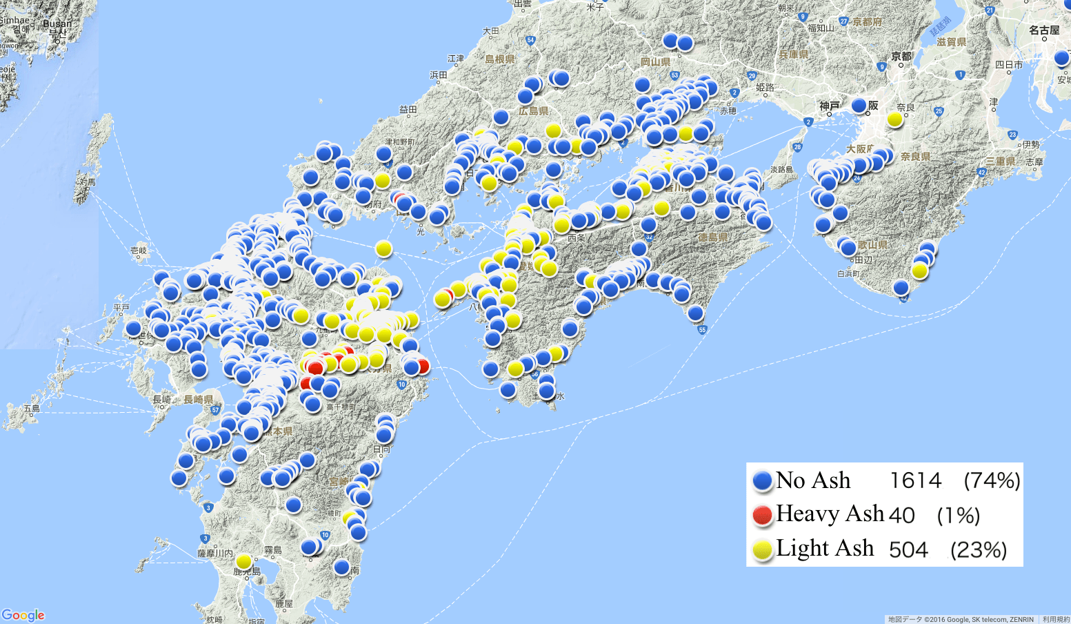
To investigate the spread of falling ash, Weathernews conducted a survey among millions of our Weather Reporters across Japan. Through our smartphone app, Weathernews Touch, we asked multiple choice questions about falling volcanic ash with possible answers: No Ash, Light Ash or Heavy Ash: and received 2,158 replies from people in Western Japan. People in the northeast of Mt. Aso reported Heavy Ash from the time of eruption to noon on the 8th, while people on Shikoku Island sent us reports of Light Ash through the morning.
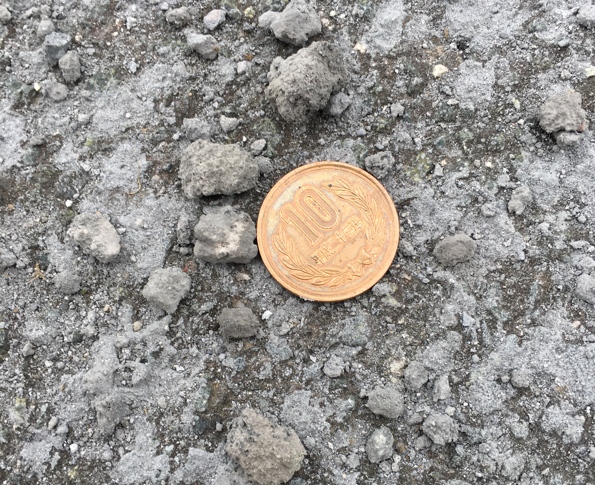
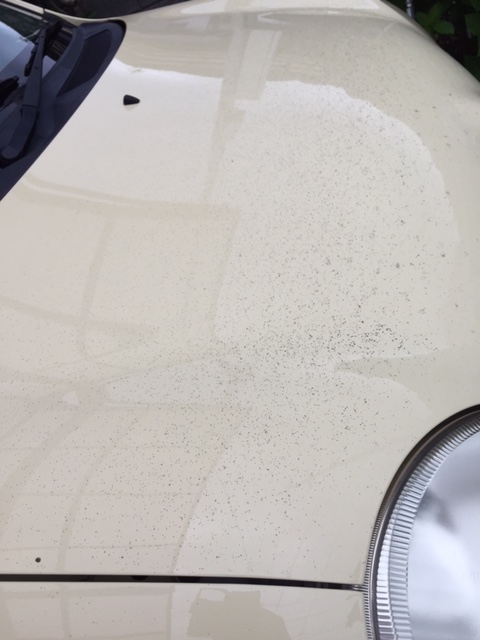
Weathernews also received ash reports with photos of black volcanic ash on the hood of their car, arm rails of verandas, and walls. According to a comment from a resident of Aso City:
“I was in Aso City, 10km northeast of Mt. Aso. I woke up to a sound like hail hitting the house, and when I looked outside, there was gravelly ash falling. There was a temporary power outage, but it’s been restored.”
There were also reports from Fukuoka and Ehime Prefecture of sulfur-like smell reaching them.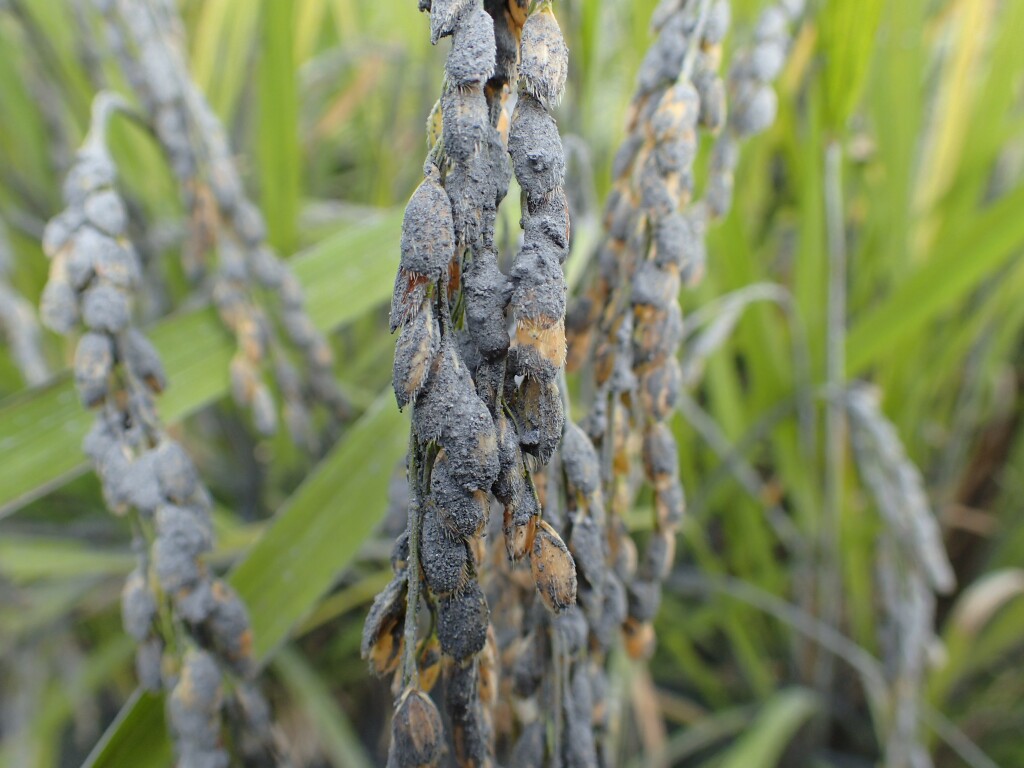

Weather reports on Oct 8th
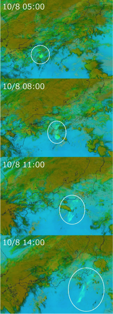
At 01:46 JST October 8th, the Terrestrial Phenomena Center at Weathernews issued a prediction that volcanic ash would be expected to pass through Shikoku Island and spreading over Kanto area and eastern sea of Japan into the afternoon (Fig. 1). As wind speeds and directions in the upper atmosphere vary with altitude, the accuracy of the volcanic ash diffusion forecast depends on how well the height of volcanic ash cloud could be estimated. Although this eruption happened at night, the Terrestrial Phenomena Center could correctly estimate the dispersal volcanic ash from WITH Radar observation. After that, we monitored volcanic ash cloud by image analysis from Himawari-8 Satellite’s three-band infrared sensors (Fig.2). From the comparison between this image analysis and our diffusion forecast, we confirmed that our diffusion forecast of volcanic ash at altitudes above 8,000 meters was appropriate.
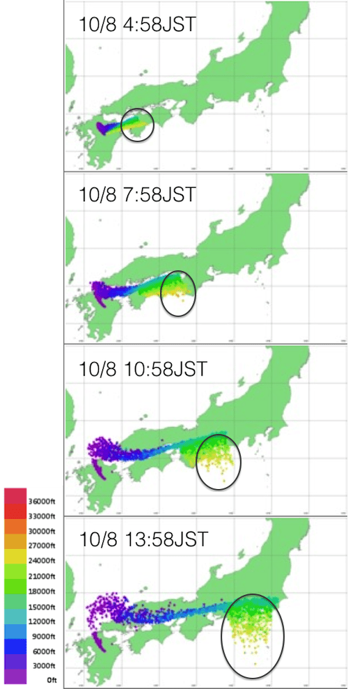
Yellow: The forecast of the altitude about 8,000m
According to JMA, the eruption of Mt. Aso on 8th was estimated to be phreatomagmatic eruption. Since there is the same chance of a similar explosive eruption occurring again, we are continuing to reinforce WITH Radar scans and monitoring in order to detect volcanic ash conditions in real-time.