News & Press Release
Weathernews Looks Back on Sea Ice in the Arctic Sea in 2017
Smallest Winter and Sixth Smallest Summer Arctic Ice Area on Record
WNISAT-1R Clearly Captured the Opening of the Northeast Passage
Shipping > The Global Ice Center of Weathernews Inc. (Chiba, Japan; Chihito Kusabiraki/CEO) announced its observation summaries of the Arctic Sea ice in 2017. Sea ice is usually at its peak surface area in February or March of each year, and at its smallest in September. This season’s largest area was in March and measured 13.9 million km2, which is the smallest on record since observations began in 1979, breaking the record set just last year. In addition, the September surface area was 4.47 million km2, which is the sixth smallest season on record.
Meanwhile, the Northern Sea Route’s (NSR’s) Northeast Passage (Russian side) was open (*) from September 3rd, about three weeks earlier than last year. On the other hand, the Northwest Passage (Canadian side) did not open this year due to sea ice remaining in the straits of the Canadian archipelagos.
Since 2011, Weathernews provided the Polar Routing Service to support safe passages for vessels in the Arctic Ocean. Weathernews has begun experimental observations of sea ice using the proprietary satellite WNISAT-1R, and was able to clearly confirm the opening of the Northeast Passage. Weathernews will continue to increase the frequency of sea ice observations to provide high quality service.
(*)Definition of open: A state in which the entire route can be traversed without entering any areas affected by sea ice according to the satellite data.
Smallest Area on Record in for Winter, Sixth Smallest Area for Summer, Only the Northeast Passage Opened
The surface of the sea ice in the Arctic Ocean is largest in February or March, and the smallest period is in September. This March, the peak surface area was 1.39 million km2 which is the smallest on record, breaking last year’s record. However the rate of melting was about the same as a normal year, and the September smallest area was 4.47 million km2 making it the sixth smallest season since observations began in 1979.
As regards the Northern Sea Route, melting along the Russian coast was faster than last year, allowing the Northeast Passage (Russian side) to become open by September 3rd, three weeks earlier than last year. On the other hand, the Northwest Passage (Canadian side) did not open due to ice remaining along the straits of the Canadian archipelagos.
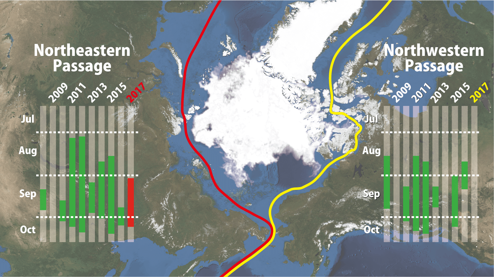
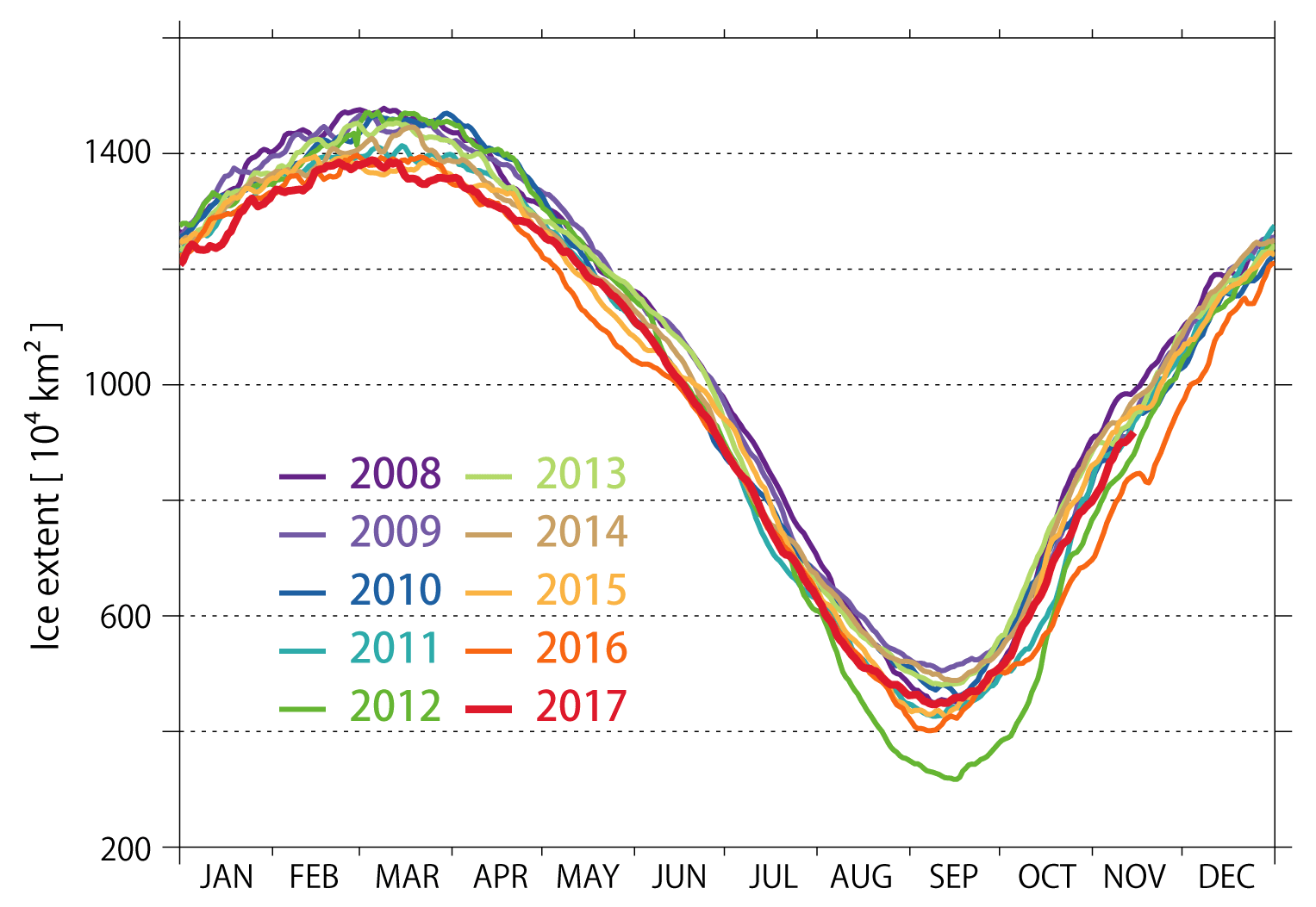
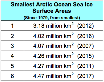
Table 1: Arctic Ocean Sea Ice Area Records
Proprietary Satellite WNISAT-1R Confirmed the Opening of the Northern Sea Route
In the middle of the Northern Sea Route is the Vilkitsky Strait (Russia), considered the greatest obstacle on the route. The melting of the sea ice in this area is key to sailing via the Northeast Passage.
Figure 3 is the first observation (the so-called first light) of WNISAT-1R, launched by Weathernews in July, and shows the Vilkitsky Strait on July 24th (Coordinated Universal Time). Sea ice can be seen in the strait, indicating that the Northeast Passage was not yet open. Figure 4 shows that by September 16th there was no sea ice in the Vilkitsky Strait, and can clearly be seen that the Northeast Passage was open.
 as seem from the WNISAT-1R. Time: Jul-24 19:45 UTC | 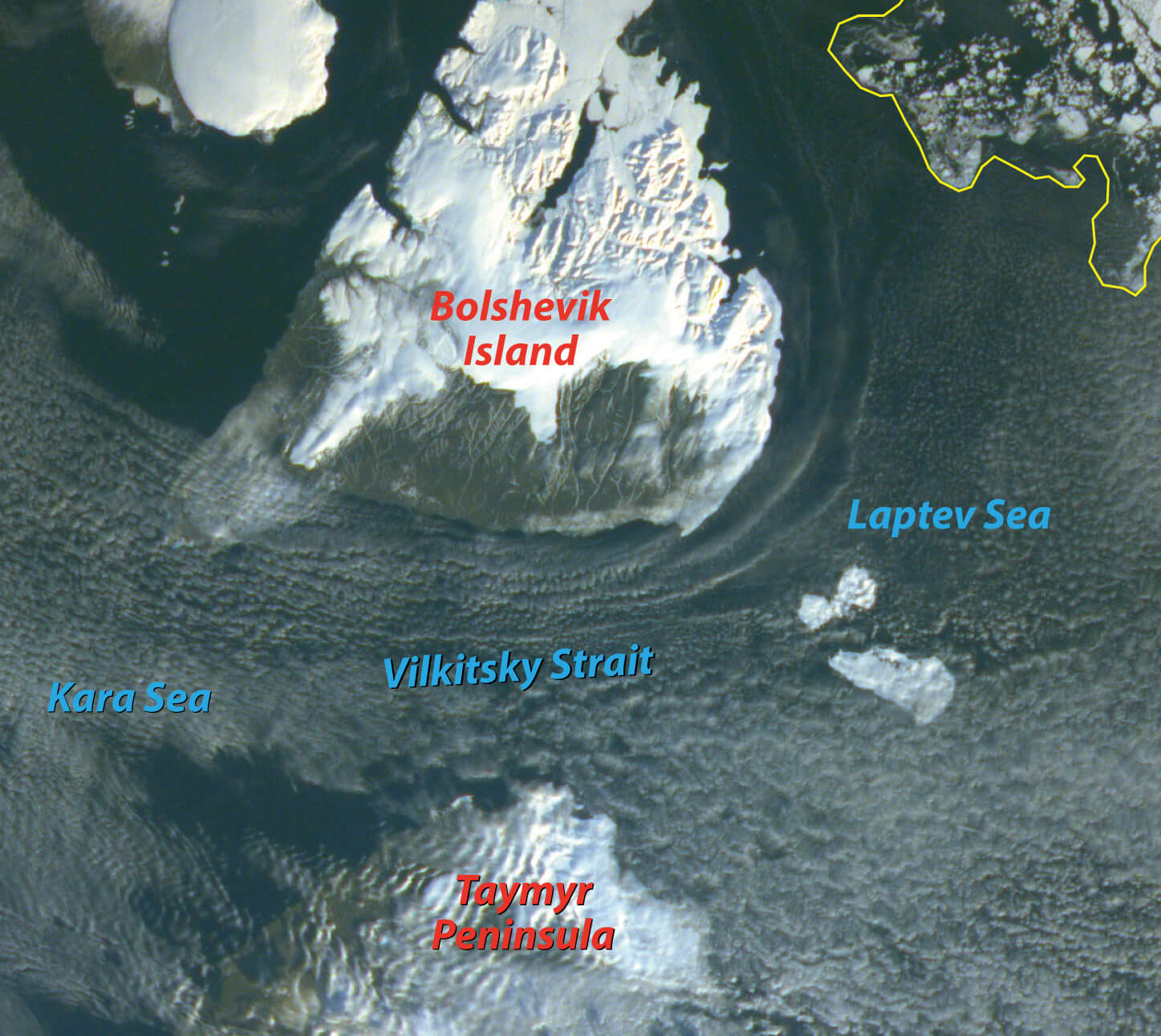 as seem from the WNISAT-1R. Time: Sep-16 01:04 UTC |
The Weathernews Global Ice Center obtains and analyzes observational data from satellites operated by domestic and foreign organizations in order to monitor and forecast sea ice over the Arctic Ocean. However, in order to support safe passages across the Northern Sea Route, more sea ice data is needed, and the present satellites by themselves are deemed insufficient. To that end, Weathernews has developed a micro-satellite whose mission is to observe sea ice, and in July of this year, the proprietary satellite WNISAT-1R was launched and tests of observations of sea ice have commenced.
Figure 5 shows an image taken by the multinational satellite Terra on the same day as Figure 3. In contrast to the timing that WNISAT-1R took the image in Figure 3, there was widespread cloud cover when Terra flew over the Arctic Ocean, making it difficult to observe sea ice.
Cloud cover makes or breaks successful remote observation of sea ice, so by increasing the number of satellites, the number of observations will also increase, giving a greater chance at obtaining clear image data of sea ice. By using data from multiple satellites, we can then obtain a more detailed understanding of the sea ice conditions.
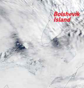
as seem from the Terra.
Time: Jul-24 12:10 UTC
Additional uses are expected to arise in the future for resource development in the Arctic Sea and utilizing the Arctic Sea routes. Based on Weathernews’ know-how in the Arctic Ocean, augmented by original observations from our proprietary satellite, we will continue to support safe and efficient voyages across the Northern Sea Route.