News & Press Release
Weathernews Looks Back on Sea Ice in the Arctic Sea in 2016
Smallest Winter and Second Smallest Summer Arctic Ice Area on Record
WNISAT-1R Microsatellite to be launched in 2017 towards Better Arctic Sea Ice Observation Network
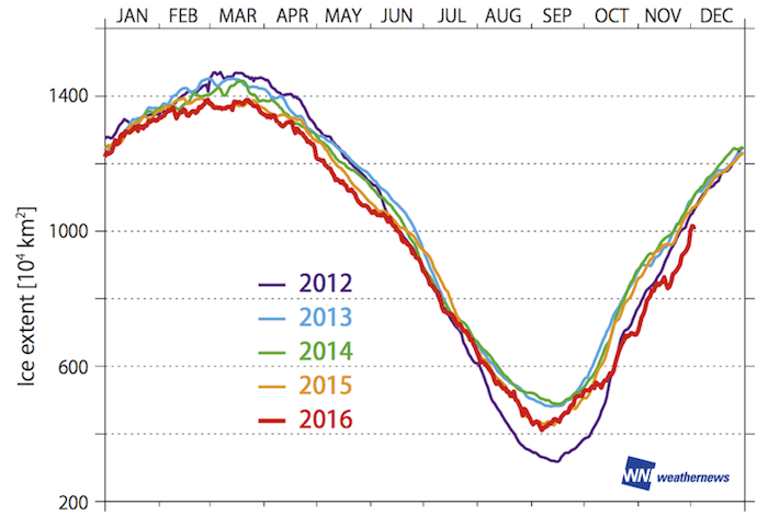
Shipping >The Global Ice Center of Weathernews Inc. (Chiba, Japan; Chihito Kusabiraki/CEO) announced its observation summaries of the Arctic Sea ice in 2016. This year, the sea ice continued to shrink due to warm Arctic pattern, leaving only 13.96 million km2 of ice in February, setting the record smallest area in winter. It also reached 4.14 million km2 in September, reaching the second lowest yearly minimum in the record. Meanwhile, the Northern Sea Route’s (NSR’s) Northeast Passage was open (*1) for approximately two weeks from September 24th through October 7th, which was shorter than most years, because the ice remained in the Laptev Sea.
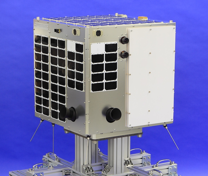
In recent times, the Arctic Sea has experienced a higher level of maritime activity because of budding resource development in addition to cargo transportation. Since 2011, Weathernews provided the Polar Routing Service to inform these ships of safer marine routes in the North Sea. As the importance of detailed sea ice information increases, Weathernews intends to launch the WNISAT-1R microsatellite for observing sea ice in the Arctic Sea, in 2017 to improve the precision of sea ice forecasts and quality of service.
Sea ice in the Arctic Sea has decreased due to Global Warming, with the Smallest Area on Record in for Winter and the Second Smallest Area for Summer
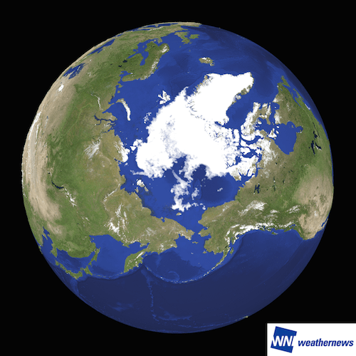
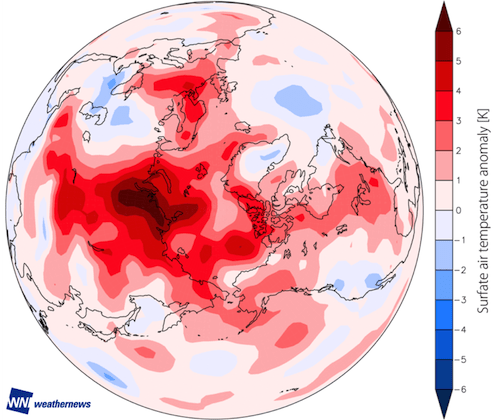
The trend of decreasing sea ice has continued in 2016. The annual maximum area 13.96 million km2, recorded on 29th February, was the smallest in recorded years. The year’s smallest area in September was 4.14 million km2, the second smallest area on record. One of the main causes is the recent warming of the Arctic. Figure 3 shows the monthly averaged air temperature anomaly in this September in the Arctic Circle, indicating the warmer climate throughout the entire area.
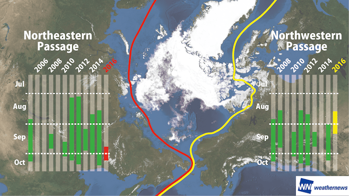
While the area of sea ice is in decline, the Northeast Passage on the Russian side was only open to traffic for around two weeks from September 24th to October 7th, the shortest traversable period in recent years. The reason for this is the sea ice remained in the Laptev Sea, a key area to open the sea route, shortening the period in which ships could traverse the passage without entering areas affected by sea ice (*1). Dotted with islands facilitating the formation of ice, the Northwest Passage on the Canadian side was open for three weeks from August 19th through September 10th.
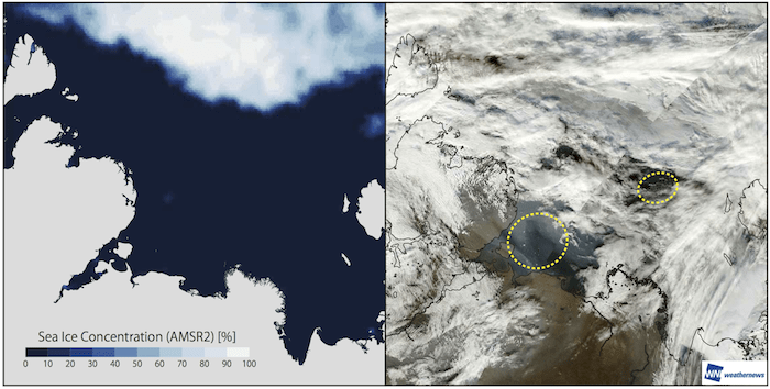
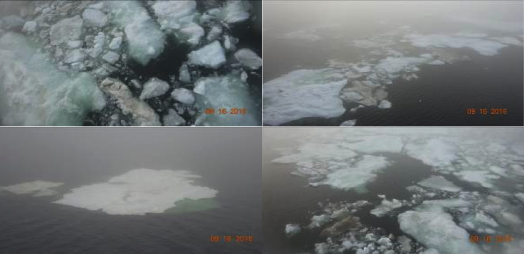
The sea ice in the vital Laptev Seaway that obstructed traffic through the Northeast Passage was difficult to detect with passive microwave satellites (*2) widely used in sea ice observation. Figure 5 compares the Laptev Sea as of September 16th in the image plotted by a passive microwave satellite and that in a visible satellite (*3) map. The visible satellite image shows sea ice in areas with no sea ice in the microwave analysis.
Photographs (Figure 6) taken from a Weathernews supported vessel that traveled through the area also show the presence of sea ice at the time.
The Northern Route has been used as cargo route in recent years, but it has become busier due to resource development. Having detailed information on Arctic sea ice has become more important now to facilitate material transportation for plant construction and regular transportation of energy.
At present, the Weathernews Global Ice Center obtains data from several satellites for observation and forecasting sea ice, but there is no visible-light satellite dedicated to observation of Arctic sea ice and there have been issues with the frequency of observation and precision of forecasting. In 2017, Weathernews intends to launch the WNISAT-1R, its own microsatellite, to increase the precision of forecasting sea ice and improve the service quality of the Polar Routing Service provided to predict safer seaways through the Arctic Sea. It has six visible-light and infrared cameras in total, which will enable the observation of smaller sea ice undetectable with passive microwave observation satellites, as was the above case with sea ice in the Laptev Sea. Furthermore, Weathernews will perform experimental observation using GNSS-R (Global Navigation Satellite System - Reflectometry) technology, which uses reflected waves from GPS and other satellites to determine the distribution of sea ice and the condition of the ocean surface in order to establish an observation method unaffected by sunlight or the weather.
Additional uses are expected to arise in the future for resource development in the Arctic Sea and utilizing the Arctic Sea routes. Weathernews will offer even more detailed and precise information to better support safer and more efficient operation of the Arctic sea routes, based on observation obtained with WNISAT-1R satellite added to its sensory infrastructure.
*1: Definition of open: A state in which the entire route can be traversed without entering any areas affected by sea ice according to the satellite data.
*2: A characteristics of observation by passive microwave satellites is an observation method measuring microwaves reflected from the objects being observed (varying depending on the type and state of the objects). It can provide observation data even at night or in poor weather when observation using visible-light satellites is difficult, but has low resolution.
*3: A characteristics of observation by visible-light satellites is an observation method measuring sunlight reflected from an object’s surface (including ultraviolet and infrared light not visible to the human eye). It cannot be used for observation at night or in poor weather, but has high resolution for detailed observation.