News & Press Release
Record Rainfall and Flooding in Southern Thailand
Tropical low pressure and northeast monsoon make caution necessary in Thailand and Vietnam for the rest of December through the New Year
Hanoi Office >Between December 1st and 7th, heavy rain in the southern part of Thailand caused flooding, disruption of transportation, and loss of human lives and property. Japan-based Weathernews Inc. (CEO: Chihito Kusabiraki) has issued the following analysis of the deluge in Thailand and an outlook for the next month.
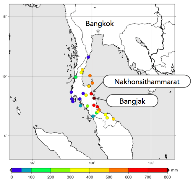
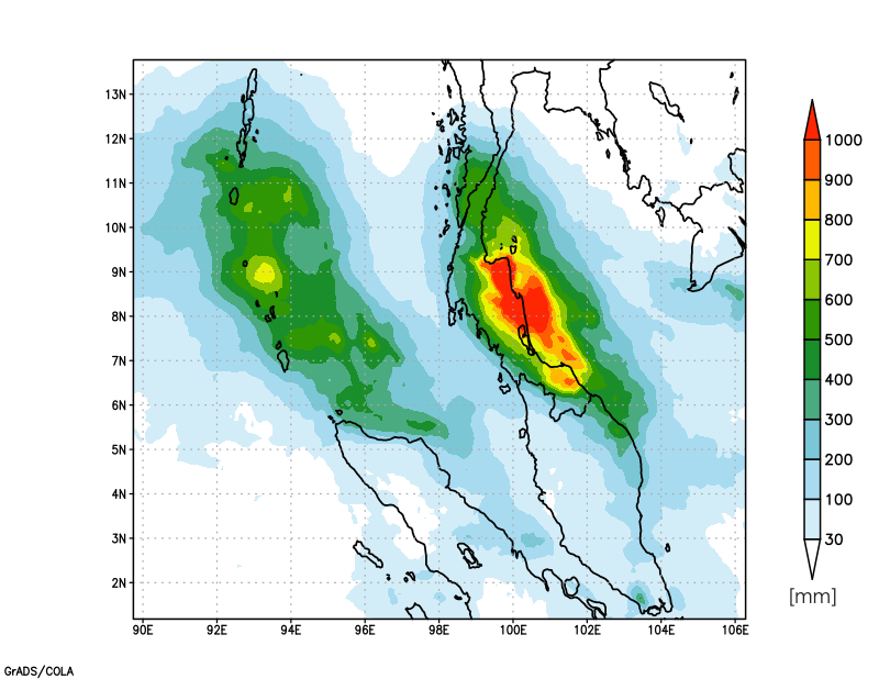
According to the Thai Meteorological Department’s Automatic Weather Stations (AWS), over 500 millimeters of rain fell over a seven-day period between December 1st and 7th over a wide area of coastal southern Thailand along the South China Sea. Bangjak in particular saw 857.6 millimeters of rainfall, and the Nakhon Si Thamarat Province got 756.2 millimeters of precipitation. (fig.1) Also in an analysis of satellite data from the Japan Aerospace Exploration Agency (JAXA), it is clear that over 1000 millimeters of rain fell over southern Thailand and neighboring bodies of water. (fig. 2)
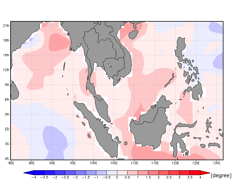
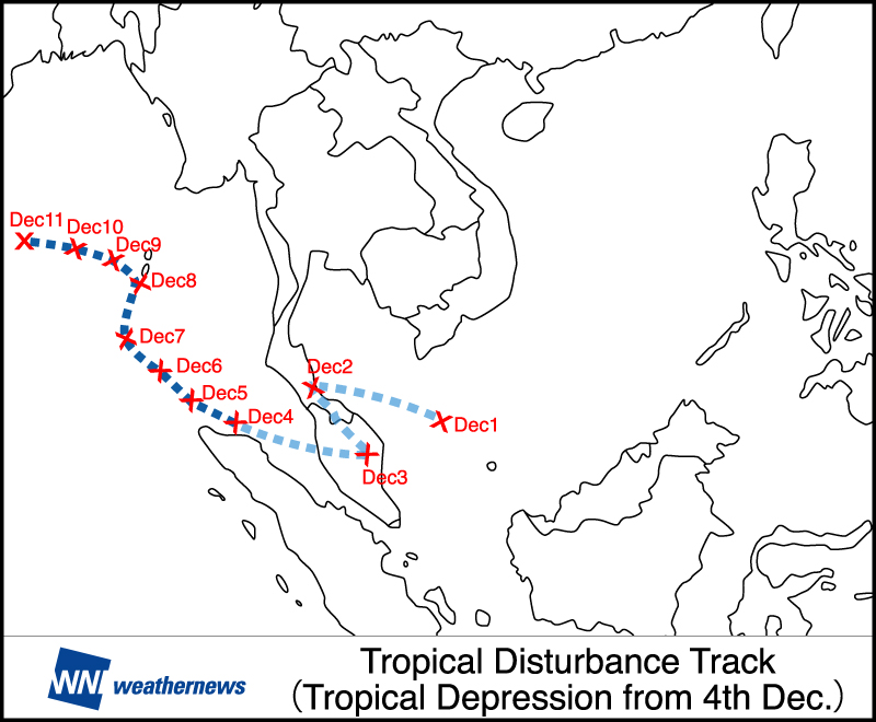
Usually the end of November is a period of intensifying convective activity over an area from the South China Sea to the Malay Peninsula. This year especially after the fall season, a La Niña event occurred resulting in high sea surface temperatures (fig.3) and conditions where cumulonimbus clouds can easily develop. On the first and second days of December, large cumulonimbus cloud formations developed in the Gulf of Thailand and passed over southern Thailand. After that, a tropical depression developed in waters west of the Malay Peninsula (fig.4), and very moist air from the approaching Northeast Monsoon continued to flow east into this tropical depression. The result of these factors became record heavy rains falling continuously over a week long period and severe rain on the southern coast of Thailand on the South China Sea.
Continued Caution Urged for the Next Month’s Outlook in Thailand and Vietnam
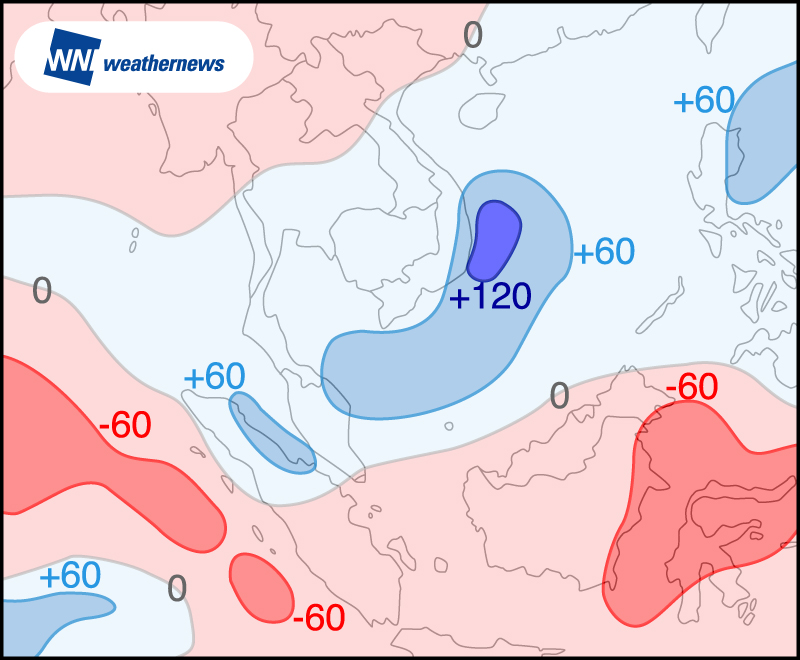
After this, the trend of high sea surface temperatures in the South China Sea is expected to continue, and conditions associated with intense convective activity are forecast. Furthermore, due to winds from the Northeast Monsoon, and since the clouds developing above that area will flow southeast, the next month after this is expected to bring a lot more rainfall to south Vietnam and Thailand than an average year. (fig.5) Already in the south of Vietnam, there are areas deluged by heavy rains, and spring tides and inundating Ho Chi Minh City are causing damage. People visiting these areas should take adequate caution of torrential rains and flooding.